| |
Willow Valley Loop - Coconino
National Forest
| Summary: |
A nice hike with climbing,
swimming, and bush whacking, through a nice
canyon at the head waters of West Clear Creek.
You'll want a warm day for this trip, since
you'll hit the swimming pools early in the day
when temperatures are cool. To do this hike I'd
suggest bringing: dry bags, floatation device
for your pack (a child's pool float toy works
good) and a walking stick (for balance on the
rocks).
Download a map of this route
here (481k). |
| Directions: |
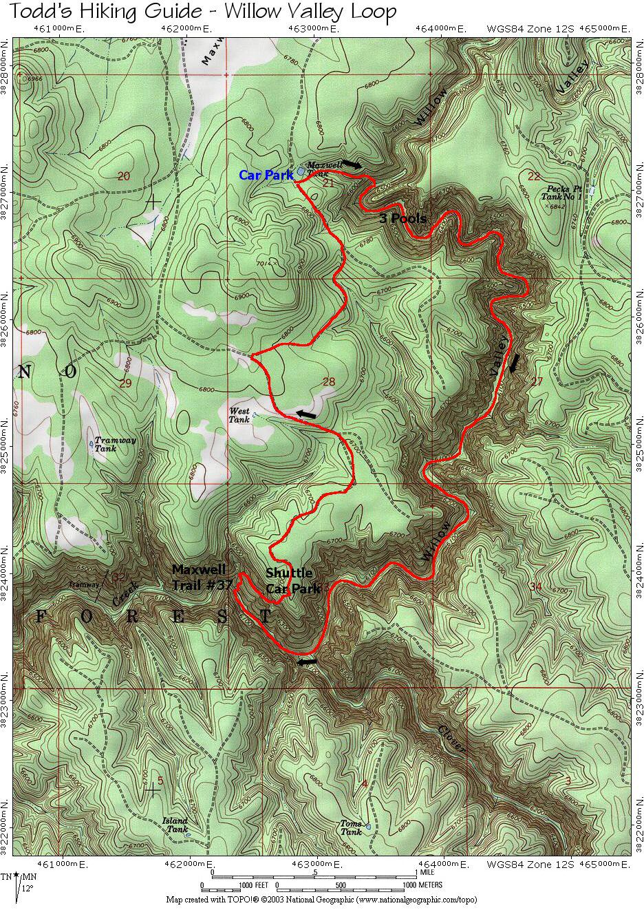
From Phoenix,
take I-17 north to Exit 306 for Stoneman Lake
Road (Forest Road #213). Head east following the
signs for Lake Mary Road (about 15 miles). At
the junction with Lake Mary Road turn right
(south) and drive to between mile markers 297 &
298. Turn right (west) at the sign for West
Clear Creek onto Forest Road (FR) #81. Follow FR
#81 for 3.1 miles then turn left onto FR #81E.
After driving 3.8 miles stay left (continuing on
81E) at the junction with FR #693. After another
0.5 miles you'll arrive at the junction with
Maxwell Trail Road. To spot a car, stay right at
this junction and follow it 1.5 miles (ignoring
any faint side roads) to the signed trailhead.
To reach the trailhead, turn left towards
Maxwell Tank. After 0.9 miles a road will come
in from the right (stay left), you will reach
Maxwell Tank after another 0.4 miles. |
| Road Conditions: |
High Clearance Vehicle |
| Navigation: |
Moderate |
| Length: |
~9.0 miles |
| Date Hiked: |
August
2003 |
| Weather Conditions: |
Hot and humid |
|
Required Skills: |


 |
| Hike Description: |
Walk east from the road past
Maxwell Tank. Hop the barbed wire fence and find
your way into the brushy drainage on the other
side. Once in the bottom of the drainage, turn
right and work your way down canyon through the
brush, avoiding the sharp thorns of the New
Mexico Locust where possible. A very faint trail
can be found in places, which makes the going
somewhat easier. Near the bottom of the drainage
you will encounter several drop offs. The author
and his wife were able to down climb each
obstacle without too much difficulty. Push your
way through the brush at the bottom to enter the
main canyon of Willow Valley (it took the author
and his wife 45 minutes to reach this point).
From this point, turn right (south) and begin
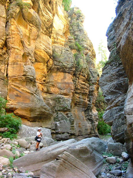
boulder hopping/climbing down canyon. The canyon
soon constricts and you will encounter three
pools in quick succession. According to Williams
(reference below), it is possible to climb
around the first two of these pools, but I swam
right through them. The third, and longest, pool
is unavoidable, and involves a tricky down climb
/ jump into a long, cool, water filled corridor
(the most scenic section of the hike). There are
no more deep wades, so if you've used a
flotation device to keep your pack dry, you can
put it away. When ready, continue down canyon.
This upper section is full of large boulders
that you'll be forced to climb around and over.
There are also a few sections that are thick
with willows, your best course of action to get
through these thickets is to stay in the main
stream channel. As you continue down canyon the
boulders eventually become smaller, and after
some hiking, the canyon begins to open up. When
running water appears in the stream bed, the
boulders give way to tall grasses which fill the
canyon bottom, and a faint trail sometimes
appears on one side of the canyon or the other
(or right through the grasses in the middle). As
you hike, you will have to wade the stream
multiple times, but if you do a little searching
you'll rarely have to go in more than knee deep.
The deep grass makes foot placement tricky
(since you often can't see the ground) and will
slow you down, so look for a path along the edge
of the canyon whenever possible. Further down
stream you will find some long sections of
decent trail through the pines that form a bench
along the canyons edge. Finally you'll reach the
confluence with Clover Creek, which enters from
the left. Stay right (continuing down stream),
you are now in West Clear Creek. After 0.5
miles, just before a prominent side canyon
enters from the right and the main canyon bends
left, look for a cairn and prominent use trail
which heads up the slope on the right (north).
This is Maxwell Trail #37, turn right and begin
climbing this steep path. The trail climbs up to
a cliff band near the top of the canyon, bends
right, then continues up past a West Clear Creek
Wilderness Boundary sign, trail register and
parking area. If you have spotted a car here,
your hike is over, otherwise, turn left and walk
1.5 miles down the road (ignoring the faint
right hand branch along the way) to the junction
with the road you drove in on earlier. Turn
right and walk the remaining 1.4 miles (stay
left at the one junction) back to Maxwell Tank
and your car.
|
| Rating (1-5 stars): |
 
The author and his wife camped near Maxwell
Tank (note: if you plan to pitch a tent you
might have a difficult time finding a spot that
is not covered with cow pies, we slept in the
back of our truck), then with an early start,
hiked the loop described above in just under 7.5
hours. |
| Maps: |
Coconino National Forest Map |
| Books: |
'Canyoneering Arizona',
Tyler Williams |
| Photos: |
Click picture for larger view, click your browser's 'Back' button to return to this page. |
 |
 |
|
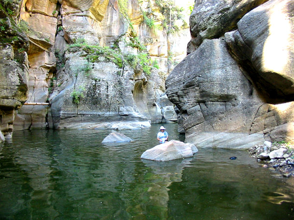
Wet section. |
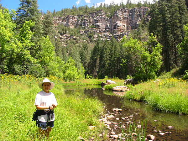
Typical scene in
the grassy
lower section. |
 |
 |
 |
|
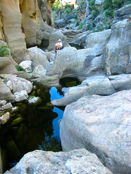
Boulders and pools. |
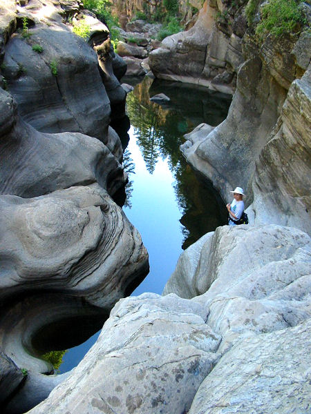
Swim #3 |
Boulder hopping. |
|
|
