| Summary: |
This hike may
be completed as a 2-3 day loop trip, a 1-2 day
through trip with a car shuttle or as an out and
back trip from the bottom. Either way, your path
will lead your through a Coconino sandstone canyon with swimming, wading, bush whacking, climbing and rock hopping.
For the loop trip, be aware that the route to Waldroup is hard to follow in some sections, so I have written very detailed instructions with this report. Be aware that you are not likely to find water until you reach Wet Beaver Creek, so it is recommended that you travel at least that far on your first day out.
The trip requires a considerable
amount of climbing, wading and swimming to
complete. In order to enjoy this hike, it helps
to be well prepared. To that end here are a few
tips:
1. Keep all your critical
gear in waterproof containers. This includes
food, dry clothes and sleeping bag. Most dry
bags leak, so it helps to double dry bag these
items or use a
dry keg. I do not suggest carrying an
inflatable boat or inner tube. These items are
heavy and easily punctured. Another advantage of
dry bags is that they will also add floatation
to your pack, which is essential for the many
long swims. With a buoyant pack, you can swim by
either laying on top of it and kicking, or
wearing it with the hip belt fastened and doing
the back stroke (my personal preference).
2. Water is very heavy, you do not want to be
lugging several gallons of Wet Beaver Creek
water out with you after every swim. Carry a
pack that drains well and that lacks open cell
foam padding that can absorb water. Grommets
should be placed in the bottom of the pack to
allow water to escape.
3. Do the hike when temperatures are very hot
(above 100 F). Swimming is unavoidable. You will
be soaked much of the time and can easily become
chilled. A wet suit may be desirable during
cooler weather or for skinny people.
4. Wear shoes that have good traction even when
they are wet. The rock in the canyon is covered
with algae and extremely slick. A walking stick
may be useful for balance.
6. Purify all water before drinking.
7. Plan your camping about an hour in advance.
Campsites are interspersed throughout the
canyon, but they may not be located exactly
where you'd like them to be. Be flexible as to
where you stop and be ready to settle for a site
that isn't ideal.
8. Be aware that heavy rains can turn this generally gurgling brook into a raging river. Check the weather
forecast, & if you get caught by a flash flood, sit it out on high ground until the water level subsides (usually within 24 hours).
Before and after photos of a flash flood in Wet
Beaver Creek may be seen
here. |
|
Hike Description: |
Out and
Back: From the Bell Trailhead, begin walking along the wide and flat path up the drainage of Wet Beaver Creek. As a sign indicates, the (historic) Bell Trail was constructed in 1932 by Charles Bell, and was used to move cattle up and down from the Mogollan
Rim (isn't that interesting?). After ~1.25 miles
you will pass the left branching White Mesa
Trail (#89), at the two mile point you will
reach a sign marking the mileage for the Bell
Trail and the junction with the left branching
Apache Maid Trail #15. The road you have
been following becomes more of a trail as it
continues to wind it's way up the drainage.
After 4 miles of hiking you will reach the
junction with Wet Beaver Creek (and a popular
swimming hole as evidenced by the large
quantities of trash everywhere). From this point
you can either head up the stream bed of Wet
Beaver Creek and hike as far as you'd like to go
or continue on the Bell Trail as it follows the
drainage of Long Canyon another 2 miles up to
the rim (see Long /
Bell Loop). When ready, return the way you came.
Loop Hike: From the Bell Trailhead,
follow the Bell Trail 2 miles to the junction
with the Apache Maid Trail #15 (note: there is
no sign identifying this trail, however, there
is a trail register). Turn left and begin hiking
up a series of nicely graded switchbacks up to the top of the mesa. At the top of the mesa there is a sign which reads "Notice: Trail difficult to find, use beyond here not recommended", if you have difficulty following faint paths, perhaps you may wish to listen to the sign
 , or you could continue straight ahead following the faint trail and cairns. , or you could continue straight ahead following the faint trail and cairns.
Note: the Apache Maid Trail heads northeast for the majority of it's length, there are some cairns and posts marking the way, but I would suggest carrying a compass to aid in navigation at questionable junctions or if you should lose the trail entirely.
From the warning sign, the trail heads northeast across the mesa, when the trail dumps you out on a road turn left and walk a short distance to a cairn on the right marking the continuation of the trail. The trail winds it's way through some junipers (and is intermittently marked with posts with the number 15 on them) around the head of an unnamed drainage, then joins up with a jeep road once again. Turn right and follow the main jeep track for quite a while. Eventually the road makes it's way so that it follows an escarpment which can be seen on the left, then around another drainage of Wet Beaver Creek which will be on your right. About 20 minutes later you will pass the Apache Maid Tanks, two cattle ponds off to the left, then cross a cattle guard.
Further along you'll come to a split in the road, the left branch heads due north, the right branch (marked with a '15' post) appears to double back to the southwest. Turn right (though it may not be intuitive) and the road soon bends back to the northeast once again. You will drop down and cross a wash, then a short distance later at the base of Hog Hill the road bends abruptly south. At this point scan the left side of the road for cairns and another '15' post. Note: two other published descriptions of this hike (including Williams' below) say to route find your way over the north side of Hog Hill to Waldroup Place, this is one way to do it, however, a better way would be to simply follow the Apache Maid Trail #15 which takes you directly there.
The Apache Maid Trail begins switchbacking it's way up the rocky north side of Hog Hill, then becomes more faint (follow the cairns and the unusually large water bars) as it continues up to the pass just to the north of the summit of the hill. Eventually the trail dumps you out at another jeep road intersection (left, right and straight), go straight between the juniper and pine tree. A short distance later you'll see a '15' post leading on a faint road to the left, here we depart from the Apache Maid Trail & stay straight on the main jeep road. The road brings you over the shoulder of Hog hill then down to another road junction (stay right) and into the grassy meadow of Waldroup Place. Follow the road down into the meadow, past another (larger) cow pond. After passing the pond your destination is the canyon on the right with the large ponderosa pine trees growing near it's head, this is Waldroup Canyon.
The remainder of the hike is contained within
the Through Trip description below.
Through Trip: From it's head, start
hiking down Waldroup Canyon. The canyon gets deep rather quickly, so the best point of entry is to walk right in from the top (rather than try to short cut into it and climb down the steep side. Waldroup Canyon cuts it's way through a layer of volcanic basalt. En route to Wet Beaver Creek you will have to negotiate 7 drop offs: 1) trail around on the left, 2) trail around on the left, 3) trail around on the right, 4) nasty bush
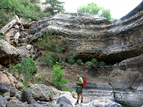
whacking trail around on the left which begins a little ways back from the drop off, 5) climb down on the left, 6) climb down on the right using a large fallen tree, 7) climb down next to a tree on the left, then another climb on the rock on the right. You may want to pass packs for the # 5, 6, 7 climbs. Shortly after the 7th climb you will hit the confluence with Wet Beaver Creek (there is a small tent site on the rocks above the creek).
Turn right and start walking down the dry rocky
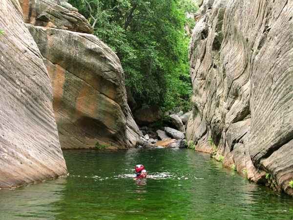
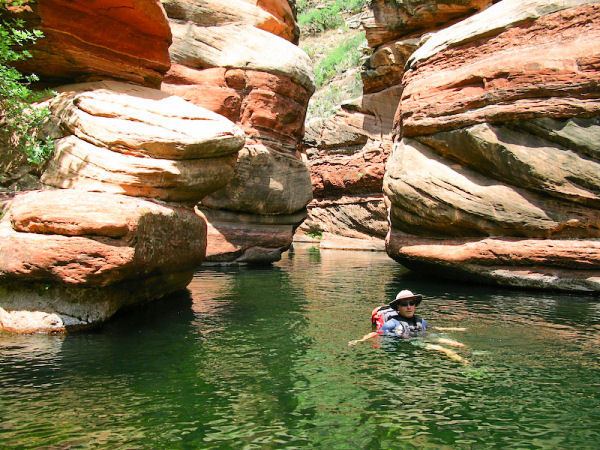
creek bed. After 15 minutes water will appear
and the first of many swims. The first two of
which occur in quick succession. This is
followed by a long dry section, before reaching
a series of swims.
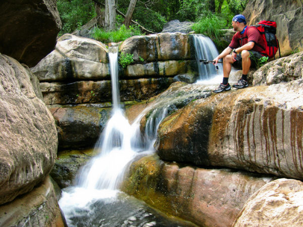
The 9 mile
hike between Waldroup Canyon and Bell Crossing consist of rock hopping and bush whacking.
When you come to a pool you simply wade in one end, maybe swim in the middle, then wade out the far end.
Rocks submerged in the water are coated with a
film of algae and are extremely slippery. This
will slow your progress to less than 1
mph in sections. When possible, forsake the
creek bed itself for look for dry boulder fields
on the side of the stream since they make for
easier traveling. Those completing the trip as a
backpack will find that while good campsites do
exist, they are few,
small and scattered.
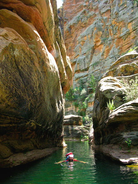
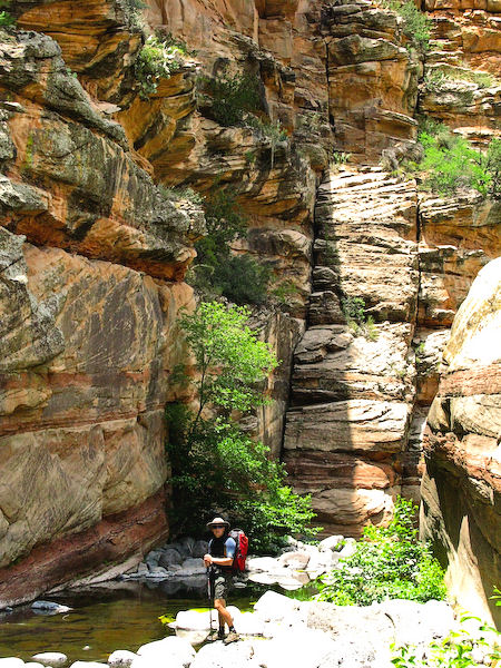
Yellow Coconino
Sandstone makes up the canyon walls for the
majority of this hike. You'll know you're
getting closer to Bell Crossing when you begin
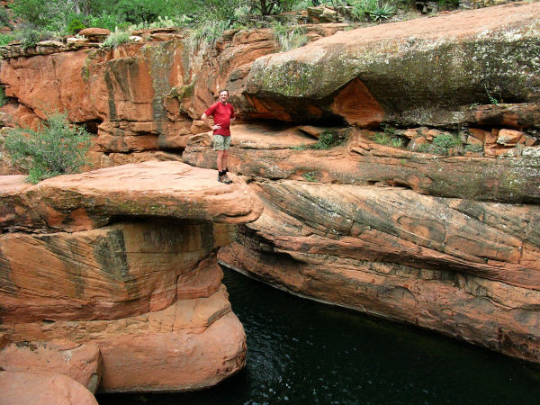
to see the red Supai Sandstone. The most scenic
section of canyon is in the Supai and there are
some nice photo ops (if you haven't managed to
drown your camera). The author counted 21 pools
which required swimming and many more requiring
wading. Eventually, at the bottom end of the canyon at
the noticeable confluence with Long Canyon (as
well as a large crowd of people) you'll reach Bell Crossing where you can pick up the well established Bell Trail back to your car. |