| |
Tanner/Beamer Trails - Grand Canyon National
Park
| Summary: |
A three day backpacking trip in the
eastern part of the South Rim of Grand Canyon National Park to the mouth
of the Little Colorado River. |
| Directions: |
From Flagstaff follow US 180 northwest
until you reach the cheesy Flintstone town of Bedrock. Turn north
(right) onto Highway 64 (which is also 180) to the south entrance of the
Grand Canyon. Turn right onto Highway 64 (East Rim Drive) where it
branches off. Drive east all the way to Lipan Point and park. |
| Road
Conditions: |
Passenger Car - paved all the way |
| Navigation: |
Easy |
| Length: |
~36 miles round trip (the best sources of
mileage I've found indicate it's 8 miles from Lipan Point to the Tanner
Delta then 10 more miles to the Little Colorado River, this seems about
right to me, but some sources I've found say it's longer) |
| Date
Hiked: |
March, 2002 |
| Weather
Conditions: |
Cool nights and mornings, warm afternoons |
|
Required Skills: |

 |
| Hike
Description: |
Day 1 - Tanner Trail to Palisades Creek: There is no water along Tanner
Trail until you reach the Colorado, so carry enough for the entire
descent. From the Lipan Point parking lot, walk back down the road a short
distance to the large sign which indicates the start of the Tanner Trail.
The trail heads east a short distance before reaching a series of fairly
steep switchbacks which descend into the canyon. Watch your footing in
this section as the rock is rather loose and slippery. After about an hour
the trail will level out somewhat at the Esplanade and you'll walk a short
ridge past the Stegosaurus Rocks to the base of Escalante Butte with views
to the left into Seventy Five Mile Creek. The trail bends to the right
(east) and begins winding it's way around the butte along a path that is
considerably more level (though there are a couple short climbs and
descents). Looking up to the right as you hike, you'll be able to see the
Watchtower (a Mary Colter design, built in 1932 as a view point and gift
shop, $0.25 per person to climb to the top of the tower), a landmark that
you'll be able to spot throughout the majority of this hike. Once around
Escalante Butte the trail crosses a tributary of Tanner Creek then
continues around Cardenas Butte eventually reaching a break in the Redwall
Limestone that will allow you to continue your descent. There are more
steep switchbacks along a loose rocky path as you make your way through
the Redwall, then a short descent through a drainage to a spot on the
Bright Angel Shale. The path bends left and levels out for a short
distance as it winds its way along a ledge then begins dropping once again
through the remainder of the BA Shale to the Dox Sandstone (a very dark
brownish red sandstone prevalent in this area). From this point you'll
have great views of the river and Tanner Delta below you. The trail winds
its way down along the side of a steep slope (watch your step, if you slip
it might be a ways before you stop sliding) before eventually leveling
out. From there it's easy walking down to the creekbed of Tanner Canyon.
Follow the cairns down the creek bed and shortly you'll come to a well
defined trail which leads off to the right. If you continue straight,
you'll wind up at the Tanner Delta which has some nice camping spots and a
composting toilet. We, however, will turn right and continue on the Tanner
Trail as it heads east (it took the author 4 1/2 hours to reach this
point). The trail climbs up to the top of the Dox sandstone and follows a
narrow path along a 200' cliff next to the river (those with a fear of
heights may find this section disconcerting, but there is nothing
treacherous about the path and the views are great). After about a half
mile the trail drops down to the beach again and continues up river (note:
there is one mildly confusing spot where you reach a little alcove, look
for steps that lead up to the base of the Dox at this point for the
continuation of the trail). The path passes through a few areas of deep
sand and across a few minor drainages then the larger drainage of Comanche
Creek to a fork. The split marks high and low water routes across the
next section. The low water route involves a little scrambling and
bushwacking and may not be possible to follow if the water level is high,
the high water route is more defined and climbs on top of the Dox
Sandstone again to follow the cliff edge along a somewhat exposed path.
Which ever way you choose the trails will bring you to the beach again and
a sandy slog to Lava Canyon Rapids and Palisades Creek. Along the way you
may see the remains of Seth Tanner's old cabin off to the right (which
isn't really that interesting if you decide to hike over to it). There is
a great camp site on the sand with a big fairly flat rock for spreading
out your stuff right on the beach next to the rapids. Total hike time for day 1 was 7 ½ hours. Be sure to hang all of your food at night, mice are active in this area.
Day 2 - Palisades Creek to the Little Colorado, then all the way back to
Tanner Canyon: From your camping site the night before, pack up a daypack with water and snacks and stash your tent, sleeping bag, etc. in a shady spot (do not leave food in your pack or the mice will eat a hole right through it). Continue on the trail up river across the wash of Palisades Creek (you are now on the Beamer Trail). The path soon begins a short, but steep climb up to the top of the Tapeats Sandstone then heads north along the cliff. The trail is mostly level all the way to the Little Colorado River. Along the first part of the trail you will wind in and out of a number of small drainages. Typically the trail drops down as it enters a drainage then climbs back out the other side. Occasionally there is a big debris pile in the drainage that you have to climb on the way in or out. Be aware that the bottoms of the drainages are quite rocky, making the path somewhat indistinct in places,
though there are many cairns marking the way. It's probably a good idea to make a mental note of the trail out as you enter each drainage so you know where to go. When you reach a point on the trail where the Colorado River splits around a small island, the drainages become fewer and the trail is easier walking for the rest of the trip. As you approach the mouth of the Little Colorado the trail descends and provides access to the Colorado River if you need water (the Park Service warns only to drink water from the Little Colorado as a last resort due to low water quality, though I am unsure whether this is due to the high mineral content or upstream pollution). The path descends to the beach and heads up the Little Colorado a short way to the Beamer
Cabin (note: the Park Service does not allow camping within 0.5 miles of
the confluence of the Colorado and the Little Colorado River). The cabin is over 100 years old and has a few signs nearby which urge hikers not to touch or enter the cabin due to its
fragility (I didn't find this cabin much more exciting than the Tanner
ruins, but the deep blue water of the Little Colorado makes for some cool
scenery - unless it has rained recently and the river is running brown).
Supposedly there are some old Hopi salt mines in this area as well, but
the Park Service says these are off limits. This is your turn around point. When ready, return the way you came (the author and his wife completed this route in 6 hours, 3 hours each way). Back at Lava Rapids, pack up your stuff and backpack your way back to Tanner Canyon. A good camp site can be found by turning right on a well defined path as you enter the Tanner Delta (if you head left you'll come to a sign for the toilet). After you turn right, look for a use trail on the right which leads up to a flat (if hard) campsite below a cliff. Total hike time for day 2 was 8 hours.
Once again, hang your food or you'll make some mooching mice very happy.
Day 3 - Tanner Canyon and out: Wake up and pack up your stuff then
retrace your steps of day one up and out of the Canyon (the author and his wife
completed this hike in 5 1/2 hours). |
| Rating
(1-5 stars): |
   
This is another great Canyon hike and one in which you are unlikely to see
many people. The author felt that 2 nights was perfect for this hike, but
some may wish to take an additional day or two to complete this hike at a
more leisurely pace. |
| Maps: |
Trails Illustrated -
Grand Canyon National Park |
| Books: |
Canyon
Hiking Guide to the Colorado Plateau -
Michael Kelsey |
| Photos: |
Click picture for larger
view, click your browser's 'Back' button to return to this page. |
 |
 |
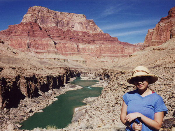
View along the
Beamer Trail. |
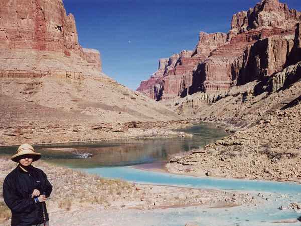
At the confluence with the
Little Colorado River. |
|
|

