| |
North Maricopa Mountain
Wilderness
| Summary: |
Easy hiking in some great
Sonoran desert scenery. The sign at the
trailhead reads: "The North Maricopa Mountains
are an example of pristine Sonoran desert.
Congress added the 66,200 acre North Maricopa
Mountains area to the national wilderness
preservation system in 1990, citing its rugged
character, outstanding opportunities for
solitude and unconfined recreation, abundant
desert flora and important wildlife habitat." In
January of 2001 the area was added to the
486,600 acre Sonoran Desert National Monument
which also includes the: South Maricopa Mountain
Wilderness, Table Top Mountain Wilderness and
the Sand Tank Mountains. There are two developed
hiking trails in the wilderness, the 9 mile long
Margies Cove Trail, and the 6 mile long Brittle
Bush Trail. Neither offer much in the way of
elevation change. Note: if you are doing a one
way hike with a car shuttle, be aware that the
Brittlebush Trail junction may be difficult to
spot from the Margies Cove Trail (I rebuilt the
cairns which mark this junction when I was here,
but who knows how long they will last). |
| Directions: |
Margies Cove West Trailhead: From
Phoenix drive west on I-10. Take exit 112 and
drive south on Highway 85 for 19.8 miles. The
pull off is not marked and is a bit tricky to
find. Drive to between mileposts 134 & 135. Just
before crossing a small concrete bridge which is
marked by a yellow and black striped sign, pull
over on the dirt shoulder on the left (east)
side of the highway (take care, cars drive very
fast on this road). If you miss this pull off, a
short distance later you will pass Woods Road on
the right (west). From the pull off, follow a
small dirt road which parallels highway 85 for a
short distance, passing a corral and large metal
tank, before bending left (east). There is a
gate at this bend that you will have to open in
order to continue. Close the gate behind you and
follow this well graded dirt road west (ignore
any branches or side roads). After 3.8 miles you
will see a prominent road which branches right
(south). About 50 feet down this side road is a
brown sign marking the North Maricopa Mountain
Wilderness. Follow this road (which is bumpy in
places) 1.3 miles to the end, where there is a
well developed parking area with restroom and
picnic table.
Brittle Bush Trailhead: From Phoenix drive west
on Maricopa Road #238 to between mileposts 10 &
11 (11 is to the east). Turn north on a good
dirt road marked with a wooden 'Trail' sign. You
will soon pass a large sign for the Sonoran
Desert National Monument. Drive 1.3 miles to an
old coral, follow the brown plastic 'Trail'
signs into the coral then to the left. Stay
straight at the junction where the Butterfield
Stage Route Trail branches to the right. After
another 1.8 miles turn right (following the
signs), and 2 miles later stay to the right once
again (straight will bring you to a
non-functional watering hole for game). In less
than a mile you will reach the trailhead parking
area next to some low rocky hills. |
| Road Conditions: |
High Clearance Vehicle |
| Navigation: |
Moderate - Difficult, you
will be following an unmarked wash for the
middle third of this hike, while it is not
terribly difficult to follow, lack of water
makes getting lost in this area potentially
dangerous |
| Length: |
Margies Cove Trail: 9 miles
one way, 18 miles round trip
Brittlebush Trail: 12 miles round trip |
| Date Hiked: |
December 2002 |
| Weather Conditions: |
Foggy in the morning, then sunny & nice |
|
Required Skills: |
 |
| Hike Description: |
Margies
Cove Trail: The Margies Cove trail runs from west to
east across the heart of the N. Maricopa
Mountain Wilderness. From the west parking area, pick up a map
at the register, then head through the brown
metal gate and stile and begin following an old
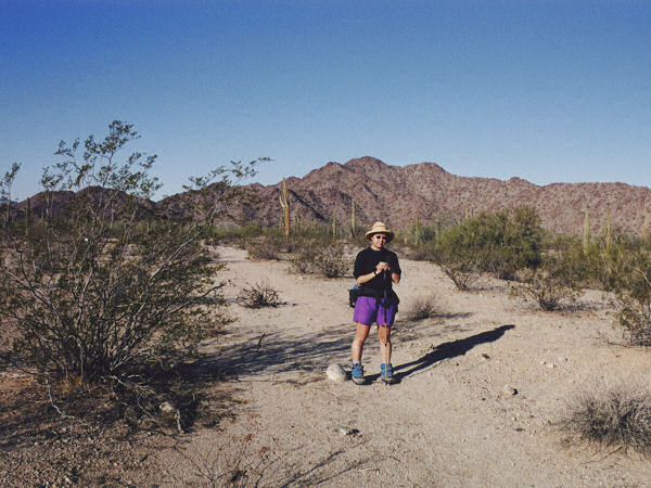
road to the southeast (0 miles). The path leads through
creosote flats with creosote bush, palo verde &
some very large specimens of saguaro (many) and
ocotillo (few). A short walk will bring you past
an old corral and metal tank, then, after
passing through another fence, the trail begins
bending more to the east. Since the desert is
wide open, you may find staying on the path
slightly challenging. Keep an eye out for brown
plastic 'trail' signs and large rock cairns in
this area. The trail is almost totally flat and
remains that way the entire distance. After an
hour or so of walking, the path dumps you into a
wide sandy wash (fortunately the sand is fairly
well packed and not difficult to walk on). At
this point the large rock cairns you have been
following cease, and it will be up to you to
remain on course. You basically want to continue
heading east, following a series of dry washes
that run between rocky hills. When the author
was here, there were several pairs of faint
footprints to follow, if hiking after recent
heavy rains this may not be the case. After
walking the dry streambeds for half an hour or
so, the wash becomes a shallow gully, continue
through the gully. On the other side, when the
hills fade back a bit, look for a small wash on
the right and some large cairns. The cairns lead
you up out of the wash on the right and follow
what might have been an old road. The cairns are
found at frequent intervals for the remainder of
the hike. The path soon leads you back into
another wash, which you will follow to a fence
line (there is a gate just to the right of the
main wash). Finished with the dry streambeds,
the trail heads through the creosote flats once
again and soon passes an enclosed, man-made
watering hole for game animals (completely dry
when I was here). Looks like a failed experiment
to use water to attract desert species to a
central location for hunters to kill them (Q: we
wouldn't want today's modern hunter to suffer
the inconvenience of actually having to go look
for stuff to shoot would we? A: not while
we're on the trails). Another ten minutes will
bring you to the east entrance register, and a
short stroll, to the east entrance parking area
(9 miles).
If you've left a second vehicle here, your hike
is over, otherwise, return the way you came (18
miles).
Brittlebush Trail: This trail runs from south to
north, intersecting the Margies Cove Trail at
about the 5.8 mile point. From the trailhead,
walk east past the large trail sign (0 miles). A short
distance later you will come to a register (maps
may be available here). The path then passes
between two low rocky hills, then bends left to
skirt another hill, before heading cross country
through the creosote flats towards the
mountains. The trail looks like an old road in
this section. After a bit of walking, the trail
reaches the mountains and enters a wide sandy
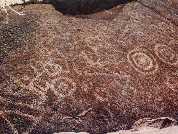
wash (note: you will skirt a prominent mountain
just to the right, if you look closely you may
see some circular faded petroglyphs on the burnished rock
of this hill, please do not disturb). Once in the wash, the cairns and
trail signs disappear, stay in the most
prominent drainage heading north (look for
footprints if they have not been washed away by
recent rains). After following the wash for a
while, you will come to a brown plastic 'Trail'
sign on the left. The path bends left at this
point and climbs up into the desert, becoming
easy to follow once again. The trail winds its
way through the desert for a while, then drops
down a short rocky hill into a wash (6 miles). This wash
is the Margies Cove Trail. If you have another
car spotted at the east or west entrances, turn
right or left respectively, otherwise, return
the way you came (12 miles). |
| Rating (1-5 stars): |
  
Nice desert scenery and easy walking, perfect
for a winter stroll. I hiked the Margies Cove
Trail first, and was unable to locate the
Brittlebush junction. The author and his wife hiked the Margies Cove
Trail from west to east and back again in about 6 hours.
I returned a few days later and hiked the
Brittlebush Trail & rebuilt the cairn at the
trail junction. Round trip time was 3
½ hours. |
| Maps: |
Pick one up at the trailhead. |
| Books: |
Exploring Arizona Wild
Areas -
Scott S. Warren |
| Photos: |
Click picture for larger view, click your browser's 'Back' button to return to this page. |
 |
 |
|
Typical view
along the
Margies Cove Trail. |
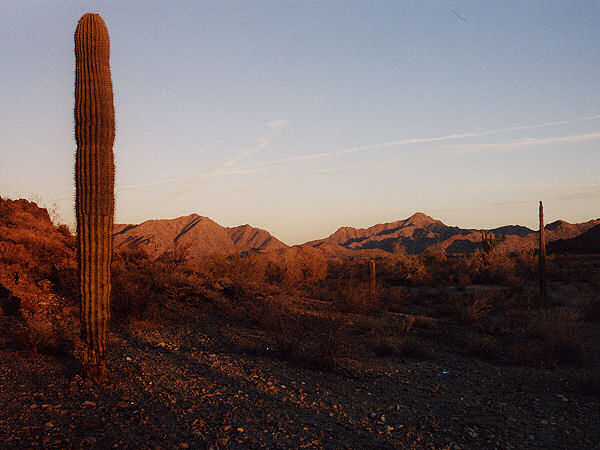
Dawn along the
Brittlebush Trail. |
 |
|
|
Faded
petroglyphs near
the Brittlebush Trail. |
|
|
|

