| |
| Summary: |
Nice hiking in some great
Sonoran desert scenery. The sign at the
trailhead reads: "Table Top is an example of pristine Sonoran desert.
Congress added the 34,400 acre North Maricopa
Mountains area to the national wilderness
preservation system in 1990, citing its outstanding opportunities for
solitude and unconfined recreation, abundant
flora and fauna, magnificent panoramic views and important
archeological features." In
January of 2001 the area was added to the
486,600 acre Sonoran Desert National Monument
which also includes the: North & South Maricopa
Mountain Wilderness and
the Sand Tank Mountains. There are two developed
hiking trails in the wilderness, the 3½ mile long Table Top Trail, and the
7¼ mile long Lava Flow
Trail. |
| Directions: |
From Phoenix drive west on
Highway 8. Take exit 144 and drive south on
Vekol Road (zero your odometer here). In 2.1
miles the pavement ends at a split; left will
take you to the Vekol Ranch, follow the sign to
the right which reads 'Vekol Valley Road, Table
Top Trailhead 13.2 miles, high clearance
vehicles only, 4-wheel drive recommended, road
not maintained, impassable when wet, do not cross
flooded washes, cell phone service is poor.' At
the 7.9 mile point at a decrepit building, stay
right where the road splits (following the
'Trail' sign). At the 11 mile mark, turn left at
a coral and go over (or around) the yellow
cattle guard. At 11.9 the road splits once again
and becomes bumpier, stay to the right (ignore
any faint secondary roads in this section). At
the 14.7 mile mark you will reach the Lava Flow
South
Trailhead which has a pull out on the right. You
reach the Table Top Mountain Trailhead at the
15.5 mile point. There are several places to
park as well as picnic tables and an outhouse. |
| Road Conditions: |
High Clearance Vehicle |
| Navigation: |
Easy |
| Length: |
Table Top Mountain: 7 miles
round trip (3.5 each way)
Lava Flow Trail: 7.25 miles one way (14.5 round
trip) |
| Date Hiked: |
December 2002 |
| Weather Conditions: |
Sunny & nice |
|
Required Skills: |
None |
| Hike Description: |
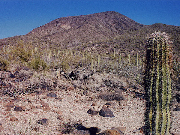
Table Top
Trail: Be aware that this trail climbs
approximately 2000 feet in
2
½ miles. From the Table
Top Trailhead walk past the wooden posts and
head through the desert on a flat path (0
miles). After 10 minutes or so, you will reach a
trail register (no maps available when I was
here). Continue onward as the trail parallels a
shallow wash through desert consisting of
creosote bush, prickly pear, saguaro, paloverde,
buckhorn cholla, ocotillo, ironwood, chain
fruit cholla and bursage. The path crosses the
wash, then soon begins climbing at an easy grade
up a low shoulder towards Table Top Mountain. As
you near the mountain, the path becomes steeper
and passes through a few very rocky sections of
basalt. After climbing a while, the trail drops
down a short distance and crosses a wash. The
path then begins a series of steep switch backs
up the west facing slope of the mountain towards
a prominent jutting rock formation, eventually
passing this formation on the right. As you near
the top of Table Mountain you will pass some low
rock walls constructed of basalt boulders (off
you your right). A short climb from the walls
will bring you to the summit, which is marked by
a wooden post and dotted with yucca, prickly
pear and ocotillo (3.5 miles). Enjoy the view &
when ready, return the way you came (7 miles).
Lava Flow Trail: The Lava Flow Trail runs
south to north through the creosote flats
connecting three trailheads (Lava Flow South,
West and North). The distance from the south
trailhead to the west trailhead is 4.5 miles,
the north trailhead is another 2.75 miles
further. The trail is flat, easy walking the
entire way. From the south trailhead, walk past
the signboard across a wash and in 5 minutes you
will reach a register (which had trail maps when
I was here). Continuing on, it's flat hiking on
an old road through wide open desert consisting
of: creosote bush, saguaro, ocotillo, buckhorn
cholla, teddybear cholla, chain fruit cholla,
barrel cactus, prickly pear cactus, palo verde & bursage. The path
heads northwest then bends more west and begins
to skirt Black Mountain (which is covered with
dark basalt boulders) to the west, crossing an
occasional wash. After following the side of the
mountain for a while, the trail bends a little
more to the west and becomes more road-like.
Soon you will see a well defined, but unsigned trail that
branches to the right (4.5 miles). If you
continue straight you will come to the Lava Flow
West Trailhead; we will turn right however, and
continue north. This section of the trail is
more of a path than a road, though it looks as
if someone graded it with a little bulldozer at
some point. The path continues north towards a
prominent dome shaped peak in the distance.
After about 1.5 miles the path bends to the
right and winds its way between some low hills
before finally arriving at a register, then 5
minutes later, the north trailhead (7.25 miles).
Return the way you came (14.5 miles). |
| Rating (1-5 stars): |

Nice desert scenery to a mountain with good
views, perfect
for a winter stroll. The author hiked the
Table Top Trail solo at a fast pace in 2
½ hours. He returned at a
later date with his wife and hiked the Lava Flow
Trail from south to north and back again in 5
hours. |
| Maps: |
Pick one up at the trail register if they have been
stocked by the ranger. |
| Books: |
Exploring Arizona Wild
Areas -
Scott S. Warren |
| Photos: |
Click picture for larger view, click your browser's 'Back' button to return to this page. |
 |
|
Table Top
Mountain. |
|
|
