| Home | Warning | Gear | Books | Photography | Hikes | Links | Flora & Fauna | Etiquette | About Me | What's New |


Paria River - Paria Canyon/Vermilion Cliffs Wilderness

Summary: This hike begins at the White House Trailhead and follows the Paria River to its end at the Colorado River and Lee's Ferry. A car shuttle is required to complete this hike. Please be aware that the difficulty of the hike can vary with the time of year  due to varying water levels and that the conditions in the canyon can change with each rainstorm. Wading is throughout the Paria, and quick sand is occasionally encountered. The depth of the water will depend upon recent weather conditions. Flash floods are a very real danger at all times of the year. Obtain an accurate weather forecast prior to entering the canyon. A permit is required to hike or camp in the area; they are available for $5 per person per day, from the BLM at: https://www.blm.gov/az/paria/index.cfm?usearea=PC
or, if the web site is down, by calling: (435) 644-4600
I've marked the major campsites and springs on the maps below. There are also many other possible places to set up a tent. Water is always available from the Paria River in a pinch, but keep in mind that there's a lot of agriculture and ranching upstream. Purify Paria River water before drinking, or better yet stick with the springs.
The Paria is usually no more than knee deep, but it would be wise to wrap critical gear (like your sleeping bag) in a trash bag in case you fall - a walking stick will also help with balance for the many river crossings and neoprene socks will be desirable during the colder months.
A car shuttle may be arranged through the following individuals / businesses:
  • Crystal Phillips - (928) 522-6514

  • Back Country Adventures - (928) 608-0860

  • Catalina Martinez: (928) 355-2295

  • Paria Outpost - Susan and Stephen Dodson, PO Box 410075, Big Water, UT 84741, (928) 691-1047

Rules, Rules and more Rules:

  • Advance permits are required for overnight use. There is a limit on overnight use in the canyon to 20 persons per day.

  • Day use permits are available via self-serve envelopes at each trailhead. There are no visitor use limits for day use.

  • Day users must display the permit on their vehicle windshield. Overnight users must display the permit on the outside of their backpack, and on the dashboard of their vehicle.

  • Campfires are prohibited.

  • Dogs are allowed. They must be kept under control at all times.

  • Human waste bags will be provided free of charge at the Paria Ranger Station, Kanab Field Office and Arizona Strip District Office. Their use is not mandatory, but helps to preserve the pristine canyon environment.

  • Use existing campsites at least 200 feet from a water source.

  • No camping on or adjacent to any archaeological site.

  • Wrather Canyon is closed to camping.

  • Group size cannot exceed ten.

  • All trash must be packed out, including toilet paper and human waste bags.

  • Use of public land for business or financial gain requires a special permit.

  • Wilderness is closed to motorized and mechanized vehicles and equipment.

Directions: Lee's Ferry (Car Spot): From Flagstaff drive north on Highway 89. Turn left on Highway 89A, drive over the Navajo Bridge.  Turn right at the sign for Lees Ferry and follow the signs for the boat ramp. Drive past the boat ramp a short distance to park in the Long Term Parking Lot near the old ferry structures.
White House Trailhead (Start of the Hike): From Highway 89 between Kanab and Page (30 miles west of Page), head south at the Paria Ranger station located between mile markers 20-21. Follow the dirt road for 2 miles to the car park and camping area at the end (camping is $5 per campsite per night).
Road Conditions: Passenger Car
Navigation: Easy
Length: 39 miles
Date Hiked: November 2007
Weather Conditions: Sunny and Cool
Required Skills:
Hike Description:

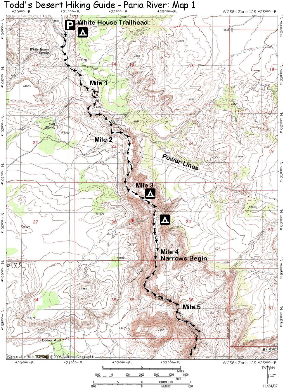
From the White House Trailhead parking lot, follow the sandy track west into the Paria River drainage and simply head downstream. Don't bother trying to keep your feet dry, you'll be hiking in the river much of the time. The Paria starts out wide and shallow with areas of 
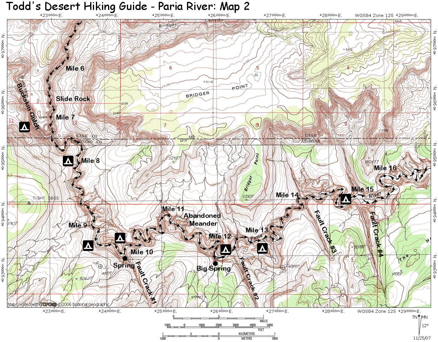
deep sand which slow your progress. After about 2.5 miles of hiking, you will pass under a set of power lines and at the 4 mile point the 
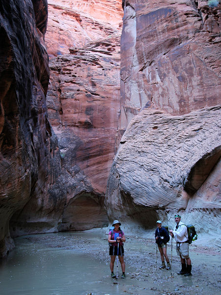
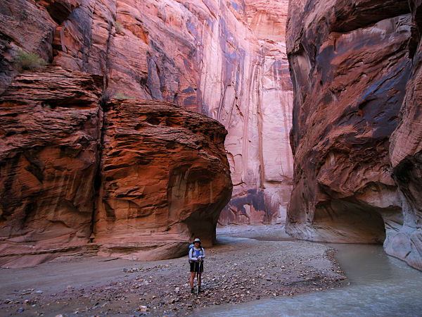
narrows begin. Though not a narrow slot like Buckskin Gulch, the river cuts deeply into the Navajo Sandstone and soon begins to travel between towering walls. Near the 7 mile point 
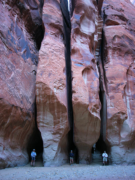
you'll pass Slide Rock Arch, which is not a true arch, but a large piece of the left canyon wall which has fallen into the canyon forming a short tunnel. A short distance later is the confluence with Buckskin Gulch which comes in from the right.

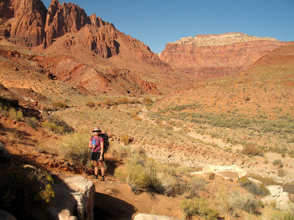
Continue down canyon through an extremely scenic canyon to a fairly reliable spring which may be found on the right at the 9.3 mile point. Just beyond is the first of four fault-line cracks which comes in from the right. At the second fault-line crack at the 10 mile point is a more reliable spring which lies at the mouth of the crack on the right. Just past the 12 mile point is Big Spring (also on the right) the largest spring in the canyon. A popular campsite sits just opposite the spring on a prominent bench.

It's more of the same below Big Spring as you pass by the second and third fault-line cracks. Just past the fourth crack is the Adams Trail and route to the rim, which is on the right (the trail is most easily seen by walking past it then turning around to look up canyon). The trail was constructed in the late 1930's to install a pipe and water pump to get 
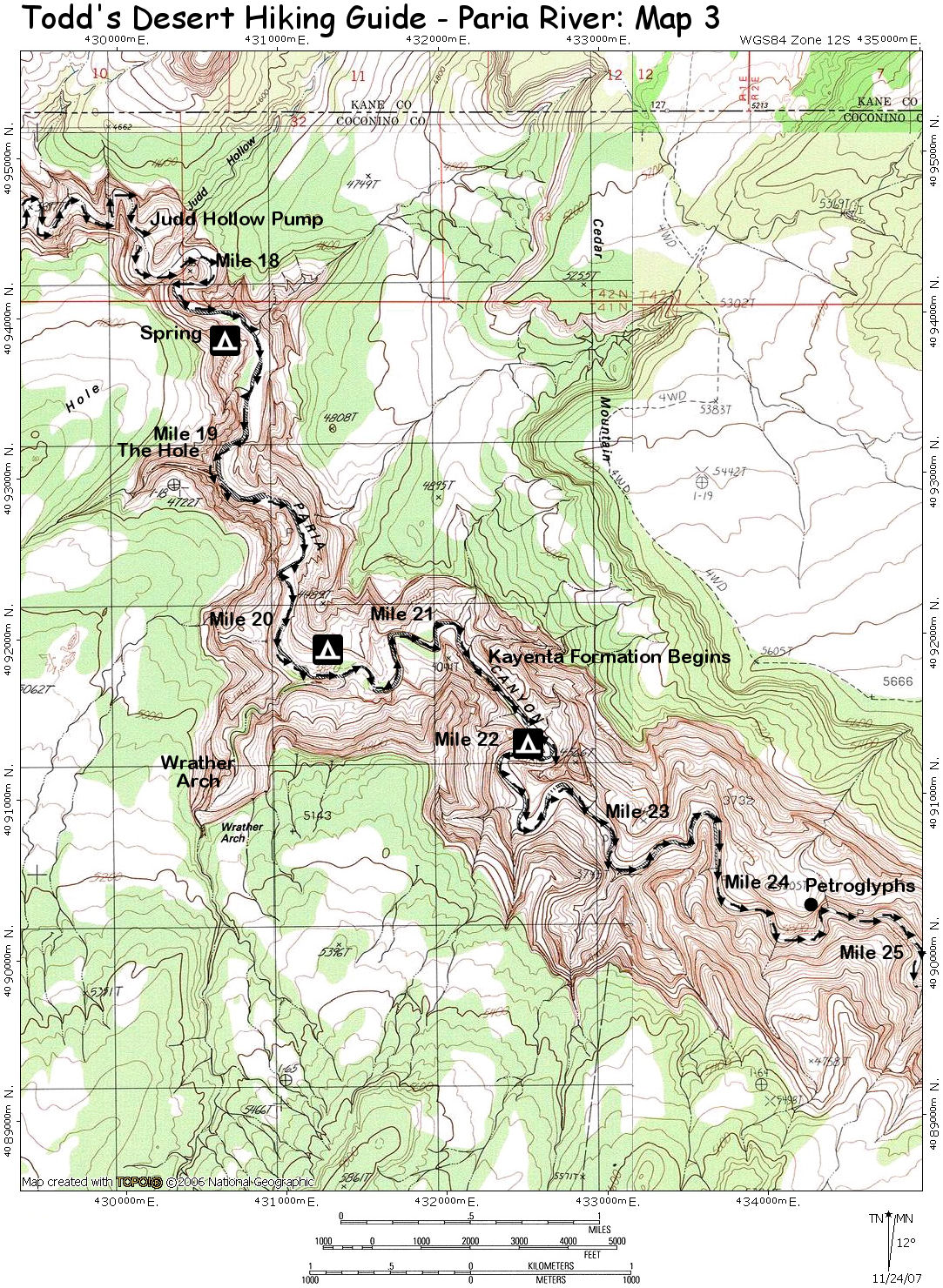
water up to the rim. The pump may be seen a few miles downstream at the 17.5 mile point in Judd Hollow on the left. Continuing downstream to just past the 19 mile point to where a minor side canyon enters from the right. This small box canyon is named 'The Hole' and features a seep from which it may be possible to get water. Another mile and a half below The Hole, Wrather Canyon enters the Paria on the right. This canyon 
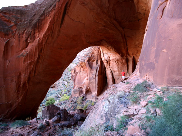
features a trail that leads 0.75 miles to Wrather Arch, the 5th largest natural arch (by span size at 246 feet) in the world. The hike to the arch is well worth a detour. In addition to a spectacular arch, the canyon itself is quite pretty and features an intermittent spring. Due to the fragile nature of Wrather Canyon, no camping is allowed.

Below Wrather Arch the canyon begins to widen and soon the Kayenta then Moenave Sandstone layers may be seen. At the 
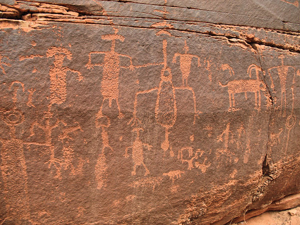
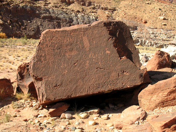
24.3 mile point, just before passing a large sand slide which may be seen on the hillside on the right, look for a large set of petroglyphs on the left just before the river makes a tight lefthand turn. About a mile downstream just past 
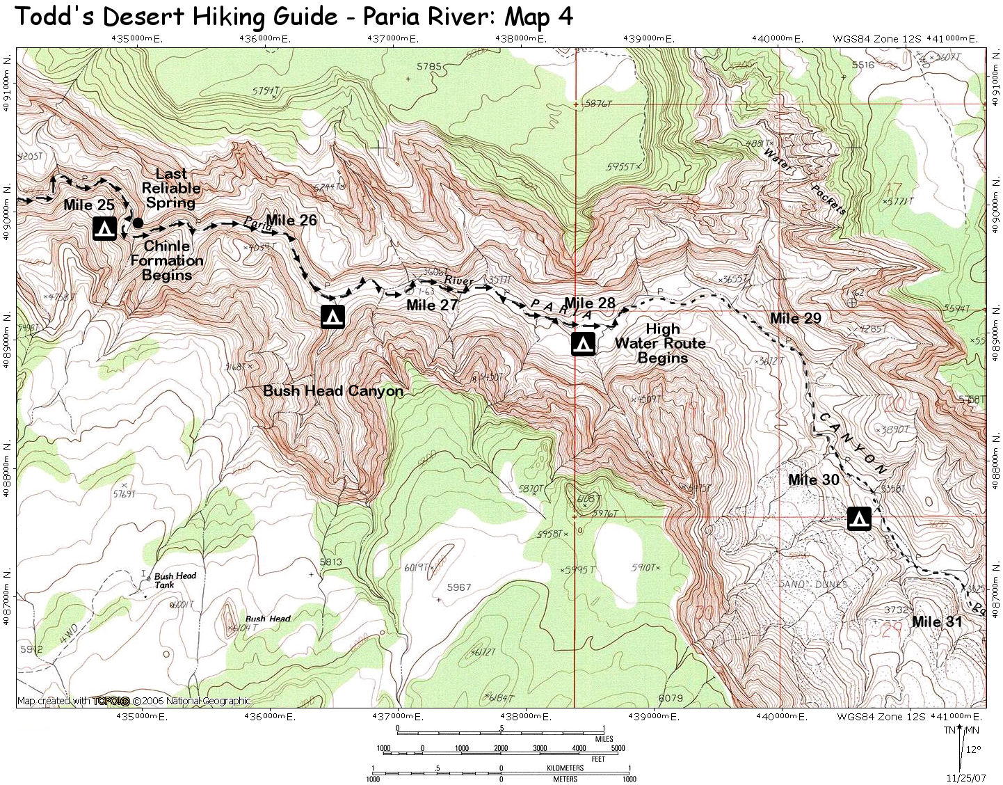
the 25 mile point you'll reach the last reliable spring which drips from a small fern covered layer in the sandstone on the left.

About a mile below the last reliable spring, Bush Head Canyon enters from the right with some nice campsites at its mouth. Below this drainage you'll have to route find through some large boulders which have fallen into the Paria, making for slow going. Keep an eye out for a trail which appears on the right which provides easier traveling. Soon the trail becomes a well established path as the walls of 
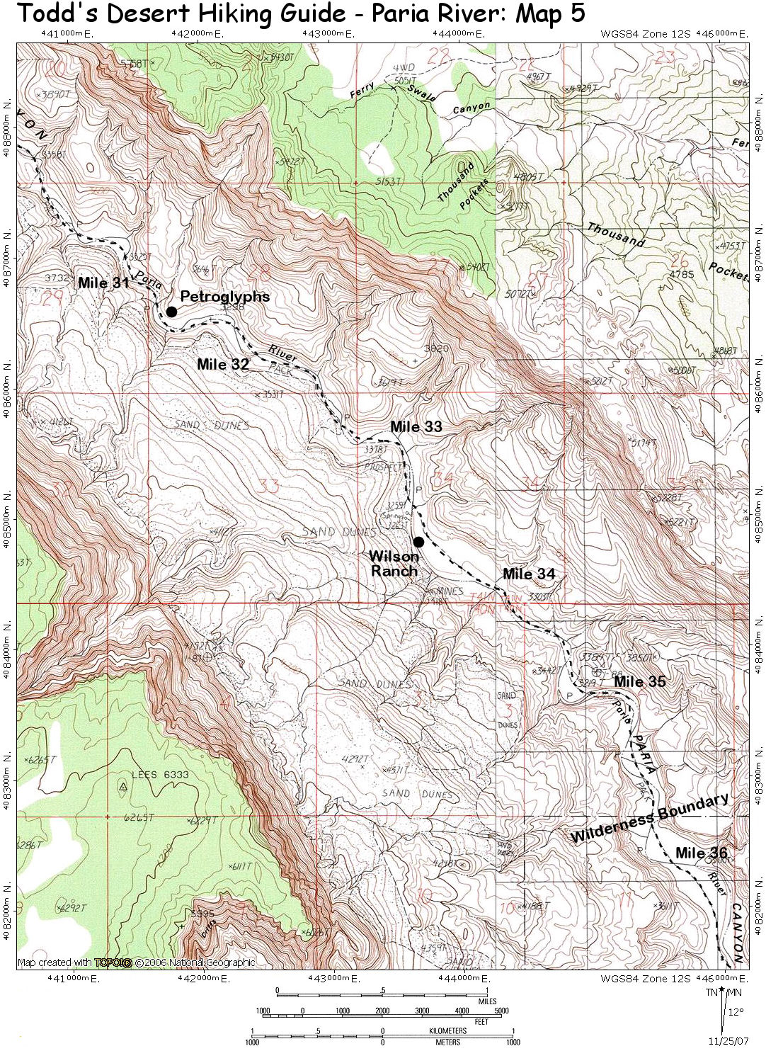
the Paria fade into the distance. At the 31.5 mile point, the path passes by a series of petroglyph panels which are found near a mushroom shaped hoodoo. Additional panels may be found on the hillside on the left a short distance down canyon.

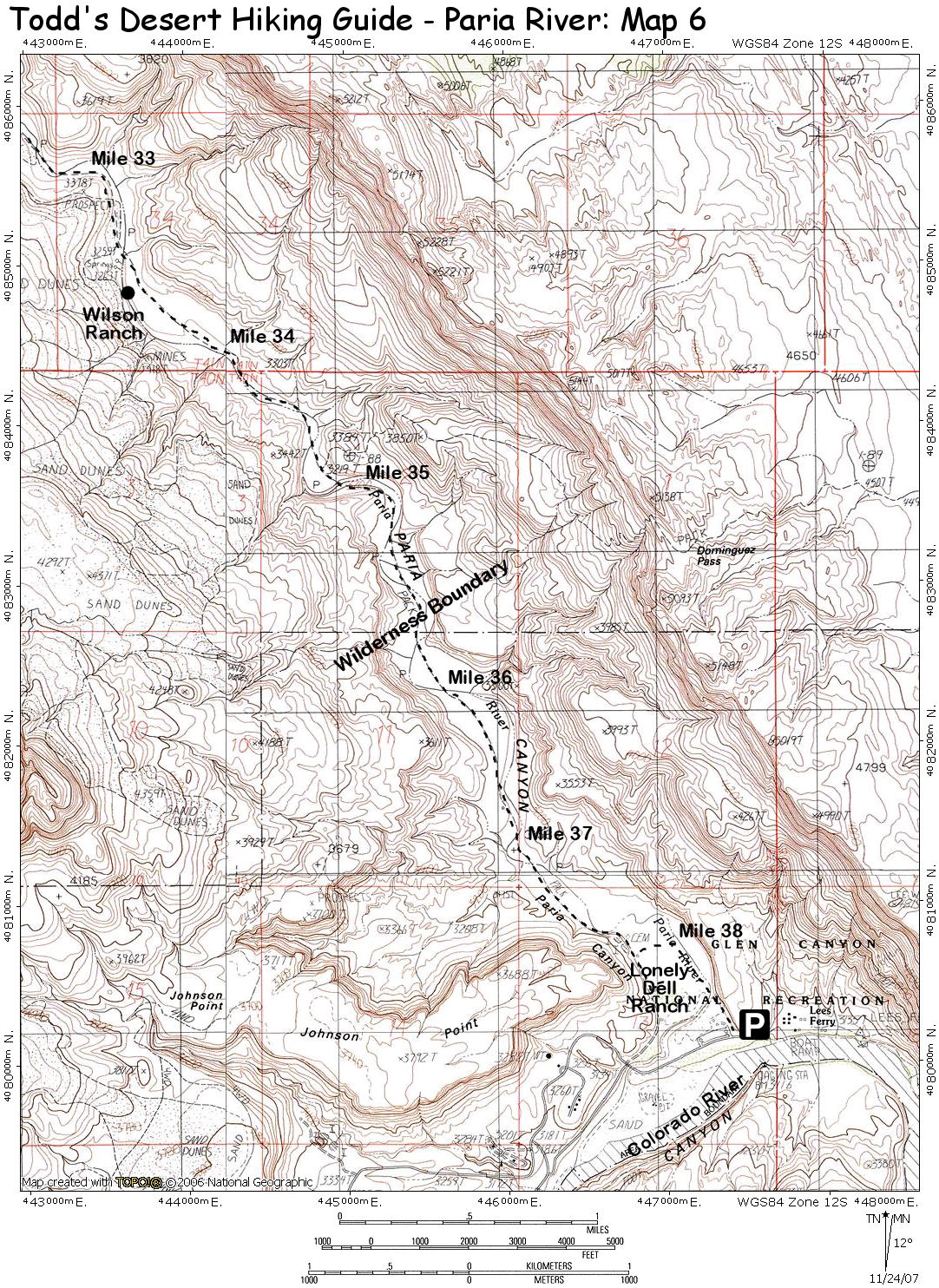
The walking is easy as you head down canyon to mile 33.5 and the remains of the Wilson Ranch. The Moenkopi Formation begins just prior to the 35 mile point and you'll reach a marked boundary separating the Paria River / Vermillion Cliffs Wilderness from the Glen Canyon National Recreation area. Passing mile point 37 you'll arrive at a trail register and soon thereafter at the Lonely Dell Ranch at mile point 38. Signs mark the left branching trail which leads to the long term parking lot and your vehicle.

Rating (1-5 stars):
The author his wife and two friends completed the hike as a fairly casual three day backpacking trip. We broke the trip into three 13 mile days camping at Big Spring the first night and the last reliable spring on the second night. Along the way we hiked up Buckskin Gulch a short distance, to Wrather Arch and spent time checking out the rock art in the lower portion of the canyon. Total hike times were 7.5 hours day 1,  7.5 hours day 2, and 6.5 hours on day 3.
Maps: Hiker's Guide to Paria Canyon - U.S. BLM
Click the following for maps for the hike: Map 1, Map 2, Map 3, Map 4, Map 5, Map 6
Books: Hiking and Exploring the Paria River - Michael Kelsey
Photos: Click picture for larger view, click your browser's 'Back' button to return to this page.
Paria Canyon Narrows
Cracks and Hikers Petroglyphs
Wrather Arch The Canyon Widens
Lower Paria Upsidedown Rock