| |
Secret Canyon - Sedona
| Summary: |
The hike travels through a nice red rock
canyon in the Sedona Secret Mountain Wilderness and can be done as either an out and back hike
from the bottom or as a through hike using a long car shuttle. For either
hike you'll need a Red Rock Pass to park, which costs $5 and is available at
one of the many kiosks in the area (look for signs). |
| Directions: |
Lower Trailhead: From Phoenix take I-17
north, to exit 278 onto Highway 179. Turn left off the exit ramp and drive west into Sedona.
At the 'T' intersection, turn left onto Highway 89A. After a few miles, turn right at the light
onto Dry Creek Rd and drive 2 miles to a right turn onto the unpaved Forest Road #152
at the sign for Vultee Arch
(quite bumpy). Drive another 3.4 miles to the signed Secret Canyon parking area on
the left hand side.
Upper Trailhead (from Flagstaff): From Phoenix, take I-17 north to
Flagstaff. Head west on I-40 to the first exit (Flagstaff Ranch Road, exit
192). Turn left at the bottom of the exit ramp, drive a short distance to a
'T' intersection and turn left. After a couple miles you'll come to a stop
sign, turn right onto Woody Mountain Road (Forest Road #231) which becomes a
well graded dirt road shortly thereafter. Drive for 13 miles then turn right
on FR #538. Another 5.5 miles will bring you to an intersection and sign
pointing right for Dorsey Spring Trail (1 mile), Kelsey Spring Trail (2
miles). Turn left and remain on FR #538 until it ends at the Secret Mountain
Trailhead.
Upper Trailhead (from Lower Trailhead): If you are already in Sedona
spotting a car at the lower trailhead, these directions will cut off some of
the driving distance in spotting a vehicle at the upper trailhead. From
Sedona drive north through Oak Creek Canyon on Highway 89A. After climbing
the switchbacks out of Oak Creek, keep an eye out for FR #535 on the left
and zero your odometer (if you hit the bridge over Fry Canyon, you've gone
too far). At an intersection at the 5 mile point, stay right on FR #535 (do
not go towards Harding Point). At the 5.7 mile point, stay straight (do not
go left into the big field), the road becomes rougher at this point and soon
enters a big farm field criss-crossed with multiple dirt tracks. Stay
straight as you travel through the field and drive past an old corral. At
the 8 mile mark, you'll pass FR #535C which enters from the right and after
10.3 miles you'll reach a 'T' junction with FR #231. Turn left on FR #231.
Drive for a few miles and turn right onto FR #538. Another 5.5 miles will
bring you to an intersection and sign pointing right for Dorsey Spring Trail
(1 mile), Kelsey Spring Trail (2 miles). Turn left and remain on FR #538
until it ends at the Secret Mountain Trailhead. |
| Road
Conditions: |
High Clearance Vehicle |
| Navigation: |
Easy |
| Length: |
For an out and back hike you can turn around any time
you feel like it. The through hike is
about 11 miles in length. |
| Date
Hiked: |
January 2000 and May 2004 |
| Weather
Conditions: |
January: cold and snowy in the canyon.
May: nice in the canyon, hot in the sun |
|
Required Skills: |
None |
| Hike
Description: |
Out and back hike from the lower
trialhead: A trail exists for the
first 5.5 miles of this hike, then you simply follow the canyon up stream. From the
trailhead, follow the trail through a manzanita covered area for 0.6 miles to a junction
with the HS Canyon Trail, continue straight on the Secret Canyon Trail. Eventually
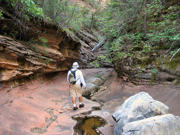
you will enter the canyon where the trail follows the stream bed on one side or the other.
After 5.5 miles the trail fades away and you are left to hike up the stream bed.
There is some scrambling and climbing required to get around a few dry falls, there
are also some nice narrows the further up you go. Return the way you came.
Through hike with a car shuttle: From the Secret
Mountain Trailhead, walk east off the ridge down the steep and loose dirt
slope down to the bottom of Secret Canyon. Take care on the descent, the
leaves and dirt make for unstable footing. Once in the canyon bottom, turn
right (south) and begin rock hopping down the dry, rocky streambed. In a few
minutes you will come to a few small drop offs in the Coconino sandstone.
The author did not find them difficult to descend. After a few short
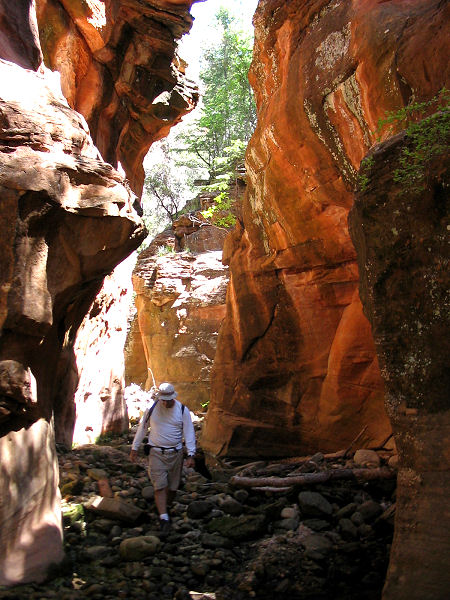
sections of unexceptional narrows, the canyon widens with the only real
obstacle being the many downed, dead trees that have fallen across the
watercourse. When you reach the red Supai sandstone, some short narrows and
pools appear. You can probably keep your feet dry by climbing or jumping
from rock to rock. Lower in the Supai a longer section of narrows appears.
There is a faint use trail on canyon left (the left side of the canyon when
facing down stream) that bypasses this section. Though you may wish to climb
down into the narrows since there are some good photo opportunities. Below
the narrows vegetation becomes more prominent and you'll be forced to do
some bushwhacking. After some thrashing through the brush, look for cairns
and use trails which will allow you to bypass the canyon bottom. As you
continue down stream the trail becomes more prominent as it travels along a
bench on one side of the canyon or the other, allowing you to make good
time. Eventually the path winds it's way through the open and sunny oak and
juniper bench and all that remains between you and the Secret Canyon
Trailhead is a hot and dusty slog. |
| Rating
(1-5 stars): |

There was quite a bit of snow and ice in the canyon when the author and his
wife first performed this hike in January. The cold weather everybody
but the helicopters away (you can count on a low fly by approximately once
every 20 minutes), otherwise we had the place to
ourselves. As you hike further upstream there are some nice (if short) narrows. The
author hiked upstream for 3 3/4 hours & back for a total hike time of 7 1/2 hours.
The author returned at a later date and hiked the length of the canyon from
the Secret Mountain trailhead at a quick pace in just over 6 hours. |
| Maps: |
Bear Tooth Maps: Sedona |
| Books: |
'Canyoneering Arizona',
Tyler Williams |
| Photos: |
Click picture for larger
view, click your browser's 'Back' button to return to this page. |
 |
 |
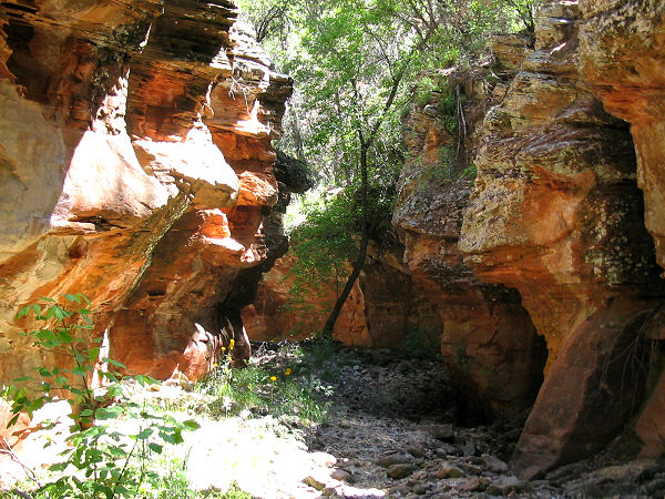
Typical
view in
the canyon. |
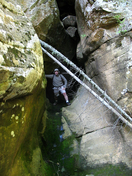
View in
one of the short
sections of narrows. |
|
|