| |
Saguaro National Park West
| Summary: |
Saguaro NP West is considerably smaller, and less remote
than its eastern counterpart, but still offers a variety of hiking
opportunities in a Sonoran Desert setting.
Hot tip: a good trail map is available for free at the Red Hills Visitor
Center (stop here first & pick one up).
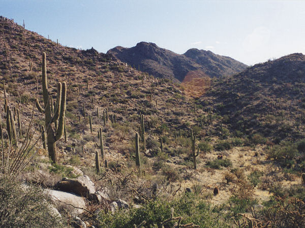
Typical plants that can be seen along the trails are: saguaro cactus
(surprised?), teddy bear and stag horn cholla, triangle bursage, creosote
bush, prickly pear, barrel cactus, palo verde, mesquite, ironwood, acacia,
and ocotillo. Be aware that the park lies within the flight line of Tucson
International Airport & Davis-Monthan AFB, you are likely to see and hear a
variety of personal, commercial and military aircraft overhead. |
| Directions: |
There are a variety of ways to get to the
park, I will describe the route I took. From Phoenix drive south on I-10. Take exit 242 for
Avra Valley Road and turn right (west) at the end of the exit ramp. Follow this road
west. Just opposite of the Avra Valley Airport follow
the sign for Saguaro National Park and turn left (south) onto Sandario Road
which eventually travels right into the park.
To get to the Cam-Boh Picnic Area and trailhead, turn left (east) onto
Picture Rocks Road. The picnic area is on the right immediately after the
sign marking the entrance to Saguaro NP.
To get to the Signal Hill Picnic Area and trail, continue south, past
Picture Rocks Rd. After entering the park turn left (east) onto the well
graded, dirt Golden Gate Road. The Signal Hill area lies a few miles ahead
on a short spur road on the left.
To get to the Hugh Norris Trailhead, continue further south and turn left
(east) onto Kinney Road. Drive a short distance, then turn left onto the
well graded, dirt Hohokam Road. Drive a short distance to the parking area
on either side of the road with room for about a dozen cars.
To get to the Desert Discovery Nature Trail or the Red Hills Visitor Center,
follow the directions above, but continue southeast on Kinney. |
| Road Conditions: |
Passenger Car |
| Navigation: |
Easy - good trail with sign posts at all trail intersections |
| Length: |
Various (see description of hikes below) |
| Date Hiked: |
November, 2002 |
| Weather Conditions: |
Nice, breezy & sunny |
|
Required Skills: |
None |
| Hike Description: |
Hugh Norris Loop Hike: This loop hike travels
around the mountains in the center of the park, with a short side trip to
the highest peak. This loop can also be performed using one of several other
entry trails (see the free map). From the Hugh Norris Trailhead, walk past
the signs and begin climbing the stone stairs. You will soon pass a
register, then it's a moderate climb up the switchbacks for a while (using
the step mill at the gym will have prepared you for this). Eventually the
path tops out at a rise, then descends briefly to a saddle (trail
construction work in progress when the author was here). The path then
begins climbing once again skirting a few peaks to the north. Shortly after
passing the fenced in remains of an old mine shaft to the left you will
arrive at the signed junction with the Sendero Esperanza Trail (which leads
left and right). Continue straight on the Hugh Norris Trail (2.7 miles). The
trail begins climbing once again towards the ridge of rocks to the east.
Eventually skirting the rocky Amole Peak on the right before descending a
short distance to a saddle and the signed junction with the Wasson Peak
Trail (4.6 miles). Wasson Peak, which has nice 360 views (since it's the
highest point in the park), lies 0.3 miles up this side trail and is worth
the trip. After returning from your detour to the peak (5.2 miles) continue
your progress on the Hugh Norris Trail as it begins descending past more
fenced in abandoned mine shafts 0.9 miles to the junction with the King
Canyon Trail (6.1 miles). Turn right onto the King Canyon Trail towards the
Mam-A-Gah Picnic Area (left will take you 3.4 miles to the El Camino del
Cerro Trailhead) and continue your moderate descent. The rocky path descends
beside a few dry washes (I guess one of which is Kings Canyon) before
leveling out at a junction with the right branching Sendero Esperanza Trail
(7.5 miles). Turn right on this level path past the left branching trail for
the Mam-A-Gah Picnic Area, then past the remains of an old stone foundation
and another fenced in mine shaft to the junction with the left branching
Gould Trail (7.9 miles). Continue straight on the Sendero Esperanza Trail
which begins climbing moderately, arriving back at the junction with the
Hugh Norris Trail 1 mile later (8.9 miles). Turn left on Hugh Norris and
follow it the remaining 2.7 miles back to the trailhead and your car (11.6
miles).
Cam-Boh Loop Hikes: In case you were wondering Cam-Boh is the
Tohono O'odham word for 'Camp'. All trails around the Cam-Boh Picnic Area
are dual use, allowing both hikers and equestrians (warning bells should be
going off right about now). These paths are all essentially flat, have been
pounded into deep sand by horse hooves, and never move far enough from the
Picture Rocks Road to escape traffic noises. If that sounds like a good time
to you, here's the poop (coincidentally, you'll be dodging poop the entire
hike). I won't go into much detail, since there is little to report, and you
can look at the map as well as I can. Here are three loop possibilities:
1) Do a 4.2 mile loop using the Cam-Boh, Panther Peak Wash and Roadrunner
Trails.
2) Hike a longer 7.3 mile semi-loop by hiking the Cam-Boh out, forming a
little loop using the Ringtail, Picture Rocks Wash and Ironwood Forest
Trails, then hiking Cam-Boh back.
3) Combine the above two hikes by performing hike #2 out and around the
loop, then on the way back detour north around the Panther Peak loop (10
miles). This is the one I did. Can't say it was a total loss as I saw many
small flocks of Gambel Quail and startled a group of javalinas.
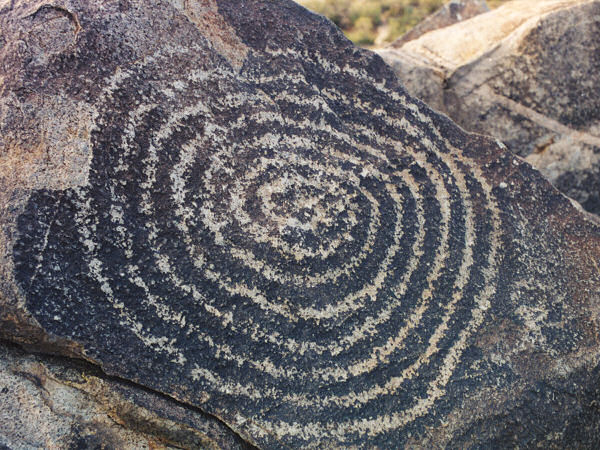
Signal Hill Petroglyphs Trail: This is an easy 0.25 hike to a low
hill which contains dozens of ancient Indian art works. Along the way you
will pass interpretive signs which detail the history of men in the region
from ancient Indians, to early pioneers, to the CCC.
Desert Discovery Trail: A 0.5 mile wheelchair accessible paved trail
with many interpretive signs detailing the natural history of the Sonoran
Desert. |
| Rating (1-5 stars): |
   For
the Hugh Norris Loop For
the Hugh Norris Loop
 For the Cam-Boh hikes For the Cam-Boh hikes
The author completed all the hikes on this page in one day with an early
start and a brisk pace. |
| Maps: |
Free trail map available at the Red Hills
Visitor Center (best)
National Geographic Trails Illustrated -
Saguaro National Park |
| Books: |
None |
| Photos: |
Click picture for larger
view, click your browser's 'Back' button to return to this page. |
 |
 |
Wasson Peak
from
the Hugh Norris Trail. |
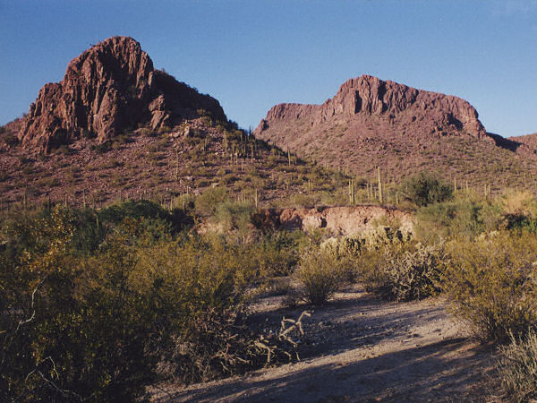
Panther Peak (left) and
Safford
Peak (right) as seen from the
wash that is the Panther Peak Trail. |
 |
|
| Petroglyphs on Signal Hill. |
|
|
|

