| Hike Description: |
A small metal sign marks at the start of a steep dirt
road marks the Turkey Creek Trailhead (0 miles, elevation 4250 ft), it
reads: Saguaro NP 3 miles, Dear Head Spring Trail 6.2 miles, Manning Camp
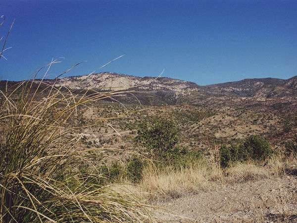
8.7 miles. Begin hiking on the dirt road as it travels north through the
rolling, grassy hills of Happy Valley. After 1.6 miles (1.6 miles) the road
ends in a small loop and trail. Begin hiking on this path as it winds at a
moderate grade in a westerly direction through an area consisting of:
manzanita, prickly pear, bear grass, oak, yucca and juniper. Looking up at
the mountain above, you will see the prominent feature of Reef Rock. After
another 1.4 miles (3 miles) you will reach a sign and gate marking the
boundary of Saguaro NP (camping permit is required, no motor vehicles,
bicycles or weapons). Another 10 minute walk and you will pass a trail
register, after which the path begins climbing considerably more steeply (in
fact many sections are like climbing stairs, since the park service has
installed many stone blocks to prevent erosion). After climbing for a while,
the trail will abruptly enter a forested area and you'll arrive at a sign
marking Mud Hole Spring (which lies a short distance up hill from the sign
and had a small trickle of water when I was here). Another sign points right
for Deer Head Spring, 1 mile (though other sources I've seen agree that it
is further than this). Head right and continue climbing very steeply on a
semi-shaded trail. Pines will become more prevalent as you gain in
elevation. Eventually, the grade flattens out as you reach a shoulder (Reef
Rock will be off to your right), then you'll drop down into a shallow
ravine. Shortly after you begin climbing again, you'll reach Deer Head
Spring (6.2 miles, 7160 ft) which was not flowing when I was here (as a
point of reference, the author reached this point 2.5 hours into the hike).
The trail continues steeply up, passes the spring & reaches a signed
junction 5 minutes later. Turn right at this junction heading towards Spud
Rock Spring Campground. You are now on the Deerhead Spring Trail heading
north on a mostly level path towards Reef Rock. The trail soon reaches a
clearing with a nice stand of Aspen trees and another signed junction (6.8
miles, 7420 ft). The campground is a short distance down the trail on the
right, we, however will turn left towards the Switchback Trail. You are now
on the East Slope Trail which we follow 0.2 miles uphill to another signed
junction. Turn right at this junction onto the Switchback Trail towards
Manning Camp (7.0 miles, 7560 ft). True to its name, the Switchback Trail
performs a series of switchbacks as it continues to climb through the pine
forest. Along the way, you will have some nice views back down into the
valley where you started the hike. After 0.3 miles, you'll arrive at another
junction (7.3 miles, 7800 ft); turn right, heading towards the Fire Loop
Trail. You are now on the Heartbreak Ridge Trail (odd how many of the signs
provide distances to other trails, yet omit the name of the trail you are
actually on). The path continues uphill, though at a now gentle grade, and
is pleasant walking. Soon you will reach a junction with the Fire Loop Trail
(8.0 miles, 8240 ft); continue straight, following the sign towards Manning
Camp. You are now on the Fire Loop Trail, which climbs a short distance,
then actually begins descending (what a concept). It drops down fairly
steeply until it enters an open area and junction with the Mica Mountain
Trail which branches back to the right (8.6 miles); continue straight and
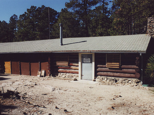
it's a short stroll into Manning Camp (8.7 miles, 8100 ft), which has water
available year round (I reached this spot in just under 4 hours).
Here's the story on Manning Camp if you're interested:
"The Manning cabin was built in 1905 by Levi Manning Surveyor General of
the Arizona Territory and Mayor of Tucson. Levi and his family spent
several summers here raising vegetables and cattle, and escaping the heat
of Tucson. He abandoned the cabin in 1907 when the Rincon Mountains were
added to the Coronado National Forest. In 1933 this area was made part of
Saguaro National Monument which was renamed Saguaro National Park in 1994.
The National Park Service uses the cabin for fire and trail crews,
researchers and rangers. The cabin provides an important base for
prescribed burn operations. Pack mules deliver supplies to this remote
cabin which is on the national register of historic places."
Looks more like a nice little resort for government employees, but what do
I know.
There are several trails out of Manning Camp; we will take
the Cow Head Saddle Trail which is on the right. The path is basically flat
as it winds its way through the pines, you may catch a glimpse of Mt.
Wrightson in the distance off to the left. The path begins descending
gradually and after 0.4 miles, then again 0.2 miles later, you'll pass signed junctions
with right branching trails, stay straight (left) on the Cow Head Saddle
Trail in each case (9.3 miles, 7860ft). As you continue to descend, the path drops down
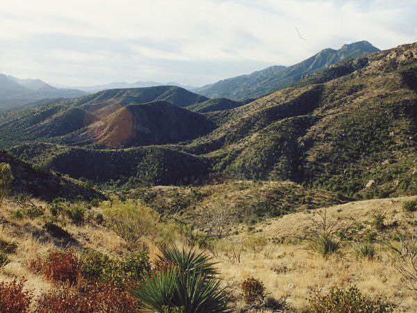
to the left of a deep ravine where you will leave the forest and enter the
chaparral before descending more steeply. After rounding a rock outcropping
(shown as a hill with elevation 7244 ft on the map referenced below) you'll
have views down into Tucson, as well as across the valley to Mt. Lemmon and
the Santa Catalina range. As you approach Cow Head Saddle, you will have to
walk down a number of long stone staircases with the steps spaced at awkward
intervals which breaks up your stride. There is a signed 4-way intersection
at the saddle (12.6 miles, 6100 ft); turn right, continuing on the Cow Head
Saddle trail heading north towards Douglas Spring Camp. More descending,
this time following a drainage which had flowing water when I was here. The
trail exits the wash and begins traveling less steeply through an area of
rolling hills and grass. Prominent plants in the area are oak, manzanita,
bear grass, sotol, and yuccas. Just after crossing a stream bed, you will
reach Douglas Spring Camp (15.0 miles, 4700 ft) which has several camp sites
and a toilet. The path bends east as it winds through the rolling hills of
the grassland. Eventually, when you catch another glimpse of Tucson, it
begins descending again. As you lose elevation, you will begin to see more
sotol, stag horn cholla and prickly pear. Soon after you see some prominent
drainages off to the left and pass the first saguaro cactus of the hike, you
will reach a junction with the Bridal Wreath Falls Trail (0.3 miles to the
falls, which flows only occasionally) and a short distance later, a junction
with the left branching Three Tanks Trail (18.6 miles, 3700 ft). Continue
straight on the Douglas Spring Trail which continues its descent, this time
beside a shallow ravine. In addition to saguaro, you will now pass ocotillo,
brittlebush and palo verde. The path crosses a wash, climbs a low hill, then
descends some more to a junction with the left branching Carrillo Trail
(19.9 miles, 3150ft). Continue straight (right) at all junctions as you
enter the desert flats below for an easy walk to arrive at the Douglas
Springs Trailhead (20.9 miles, 2750 feet). |