| |
Butterfly Trail #16, Santa
Catalina Mountains
| Summary: |
An out and back hike in the Santa Catalina Mountains
through an area heavily damaged by forest fire. Along the way you'll pass
several springs and a nice waterfall. |
| Directions: |
From Phoenix drive south on I-10 to
Tucson. Take the Grant Rd exit and drive east (left) on Grant for 8.7
miles. Turn left onto Tanque Verde and drive 3.4 miles to the Catalina
Highway. Turn left onto the Catalina Highway. Follow the highway 4.2 miles
to the forest boundary, then another 19 miles to the Bigelow Trailhead on
the right (note: based on a law suit filed against the Forest Service, fees
are no longer required at some trailheads, check the
Coronado Forest web page for current info). The Palisade Ranger Station
is 0.1 miles past the trailhead and makes for a good turn around point in
case you drive by it. |
| Road Conditions: |
Passenger Car |
| Navigation: |
Moderate |
| Length: |
5.7 miles if you spot a car at the end, otherwise 11.4
miles for an out and back hike |
| Date Hiked: |
April 2007 |
| Weather Conditions: |
Sunny & warm |
|
Required Skills: |
 |
| Hike Description: |
From Bigelow Trailhead follow the path 0.5 miles up to a
saddle and signed junction with the Butterfly Trail #16. Stay straight at
the junction heading towards the Davis Spring Trail #31. The path descends
steeply on broad switchbacks, then more gently as it contours along the side
of the steep hill in a northerly direction through an area heavily damaged
by fires that swept through the forest in 2003. Soon it drops down to a
prominent arm which protrudes from the mountain. The trail follows the arm
out to the end, then continues descending and contouring. Two miles of
hiking along the Butterfly Trail will bring you to a signed junction with
the right branching Davis Spring Trail #31 (2.5 miles). Note: The Davis
Spring Trail is in poor condition and consists of little more than a few
cairns and pieces of flagging tape. Continue straight, along the Butterfly
Trail as it drops down a few switchbacks to reach a creek which is fed by
Novio Spring. The path makes a sharp right hand turn just prior to reaching
the stream (looking for flagging tape), but those wishing to visit the
wreckage of an old airplane can leave the trail at this point and follow the
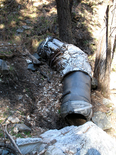
stream up canyon a short distance. The crash site has the remains of an F-86
which fell from the sky after a mid-air collision with another F-86 on July
8, 1957 as the planes were flying back to Davis Monthan Air Force Base from
New Mexico. Both pilots safely ejected and were rescued the next day. The
other F-86 involved in the crash actually stabilized after the pilot bailed
out and flew unmanned all the way to New Mexico. After checking out the
wreckage, return to the trail and follow it as it heads down stream next to
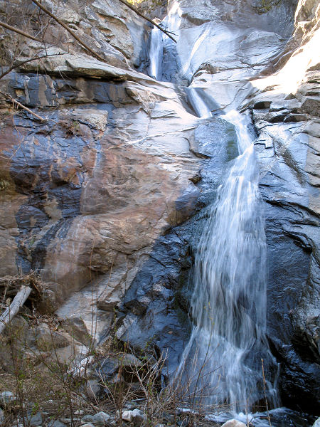
the creek. Soon you'll see Novio Falls below the trail to the right. You can
get to the base of the falls by following a minor drainage down from the
trail. After passing the falls, the trail continues traveling to the north,
and soon begins climbing steeply to eventually level out as it contours in
and out of a large drainage below Butterfly Peak. After a bit of hiking,
you'll reach the signed junction with the right branching Crystal Spring
Trail #17 (4.3 miles). Continue straight on the Butterfly Trail as it climbs
steadily for the next 1.4 miles (the evidence of fire damage decreases as
you ascend) to eventually top out at a wide path, which leads a short
distance to the Butterfly Trailhead (5.7 miles). This is the turnaround
point. Follow the trail back the way you came (11.4 miles). |
| Rating (1-5 stars): |
 
The author completed this hike in 6 hours. |
| Maps: |
None |
| Books: |
None |
| Photos: |
Click picture for larger
view, click your browser's 'Back' button to return to this page. |
 |
 |
| Typical view along the trail. |
F-86 wreckage. |
 |
 |
| Heavily burned area. |
Novio Falls. |
|
|

