| |
Divide Loop w/ Variations - Tonto National Forest
| Summary: |
Nice loop hike which
includes a very pretty waterfall, all within access from the easy to get to Bernard
Trailhead. A good alternative to the typical Barnhardt - Y Bar Basin loop.
Note: This hike was completed prior to
the Willow fire which burned through the Mazatzal Wilderness in
June and July of 2004. Actual trail conditions
may differ from those described below. |
| Directions: |
From Phoenix drive
northeast on State Highway 87 (Beeline Highway) for about 65 miles to the brown Forest
Service sign for Barnhardt Rd (FS 419). Turn left on this dirt road (a little bumpy,
but ok for passenger cars if dry) and follow 4.7 miles to the parking area at the end. |
| Road
Conditions: |
Passenger Car when dry,
road becomes quite muddy and may be impassible after heavy rain. |
| Navigation: |
Moderate - one or two
faded sections of trail |
| Length: |
~17.2 miles - based on
David Mazel's book and Forest Service signs |
| Date
Hiked: |
March, 2000 |
| Weather
Conditions: |
Nice |
|
Required Skills: |

 |
| Hike
Description: |
From the Barnhardt
Trailhead car park follow the sign for Trail #42 (Half Moon & Rock Creek Trails)
located off to the right of the parking area. The first section of trail is mostly
level and follows the base of the Mazatzal range north along the valley floor. The
trail winds in and out of a few forested canyons and through areas of juniper, prickly
pear, utah serviceberry, emory oak, yucca, hackberry and acacia the latter forming dense
thickets in places, probably a result of past overgrazing. After a short walk you
will come to an intersection with a dirt road, follow the signs to stay on the trail.
Another walk brings you through a scrubby acacia thicket, once on the other side
the trail enters a forested canyon then climbs a short ways up onto a shoulder on the
right side of the stream. The trail levels out once again and shortly brings you to
a dirt road and camp with a sign pointing back the way you came for the Half Moon Trail,
and ahead for the Rock Creek and Divide Trails, continue ahead. The trail follows a
stream bed for a ways, then bends left towards the mountain range and begins climbing.
After a short jog the trail passes a sign for the Mazatzal Wilderness, Tonto
National Forest (5 miles), then begins a steep switchbacked ascent of the scrubby slope.
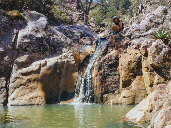
A good climb eventually brings you to a nice area with a cascading stream passing
through a granite canyon with a few nice waterfalls (an ideal lunch spot). {An
alternative, & shorter, hike may be to turn around at this point (~12 miles round
trip) or walk up the creek bed a ways to what appears to be a short stretch of granite
narrows as seen from the trail above, before returning} After your break, continue
climbing the slope, which eventually becomes less steep as it bends left and heads up
canyon to a ridge. After passing the ridge he trail drops down steeply through an
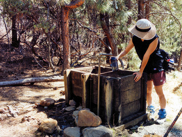
oak & alligator juniper forest until arriving at Hopi Spring, a piped spring and
trough (water was available each time the author has been here, though David Mazel's book
suggests it only flows during rainy periods). Another 75 yards brings you to the
signed junction with the Divide Trail (#23) which is also the Arizona Trail (8 miles),
turn left onto the Divide Trail. A short walk brings you to the intersection with a
sign for Horse Camp Seep (75 yards off to the right, water only during rainy periods).
Continuing on, a level walk brings you to a signed junction with the Sandy Saddle
Trail (#231), turn left onto this trail (10 miles). {Another alternative would be to
continue on the Divide Trail at this point, then turn left at the next intersection which
is with the Barnhardt Trail (#43), this will add a mile or so to the hike, but the trail
is flatter and nicer than the Sandy Saddle Trail - the author has also hiked the loop this
way} The Sandy Saddle Trail first heads up an overgrown rocky stream bed along a
very faint path (cairnes mark the way) before reaching a (what else?) sandy saddle.
After a short walk through the manzanita, the trail drops down a steep and rocky slope
before climbing once again to reach the signed junction with the Barnhardt Trail (13
miles). Turn left onto the Barnhardt Trail along a level footpath through the
manzanita. The trail then begins a steep decent along the south wall of Barnhardt
Canyon then less steeply until you arrive at the trailhead once again (17.2 miles). |
| Rating
(1-5 stars): |
 
Nice hike, fairly remote & untraveled with a nice waterfall in season.
The author and his wife completed this hike in 9 1/2 hours. |
| Maps: |
Mazatzal Wilderness Tonto
National Forest, USFS |
| Photos: |
Click picture for larger
view, click your browser's 'Back' button to return to this page. |
 |
 |
Nice waterfall through
a granite wash. |
Getting water at Hopi
Spring. |
|
|
