| |
Mazatzal Peak - Tonto National Forest
| Summary: |
A semi-loop hike, on and off
trail, to the highest peak in the Mazatzal
Wilderness.
Note: Much of the area described in this hike
shows considerable evidence of fire damage from
the Willow fire which burned through the area in
June-July of 2004. |
| Directions: |
From Phoenix drive northeast on State
Highway 87 (Beeline Highway) for about 65 miles to the brown Forest Service
sign for Barnhardt Rd (FS 419). Turn left on this dirt road (a little
bumpy, but ok for passenger cars if dry) and follow it 4.7 miles to the parking
area at the end. |
| Road Conditions: |
Passenger Car |
| Navigation: |
Difficult |
| Length: |
16 miles |
| Date Hiked: |
January 2006 |
| Weather Conditions: |
Sunny and cold |
|
Required Skills: |


|
| Hike Description: |
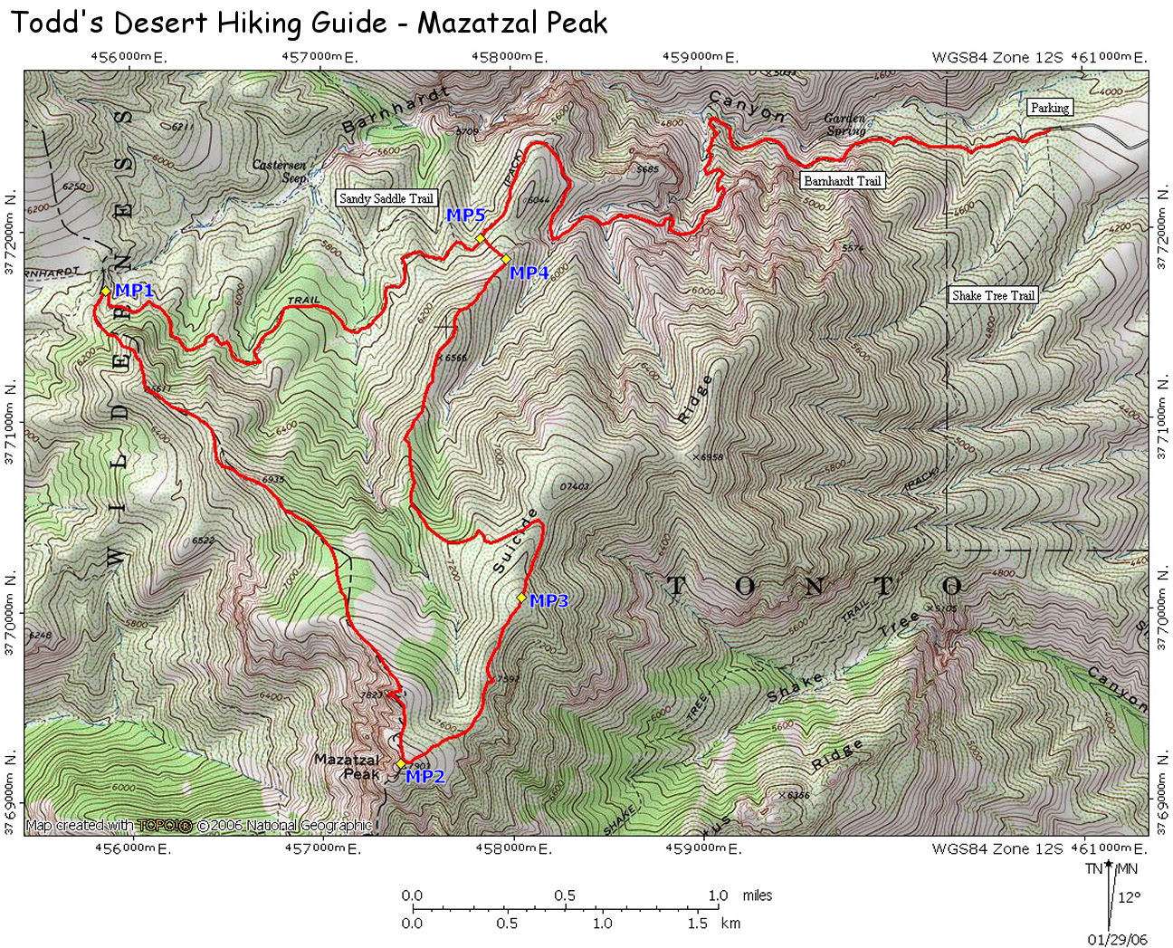
Begin walking
on the trail (0 miles, 4220 ft) just past the
large brown sign for the Barnhardt Trailhead
(this sign is supposed to show some of the main
trails in the area, though it doesn't make any
sense to me). A couple feet past the sign is a
junction (sign missing 1/06): Barnhardt Trail
(#43) heads straight & the Shake Tree Trail
(#44) heads left, continue straight ahead on the
Barnhardt Trail. The path is wide and rocky at
first as it heads through a stile then begins
following the south side of the drainage of
Barnhardt Creek through a scrub forest of emory
oak, alligator juniper, scrub oak, one seed
juniper & prickly pear. About 15 minutes later
you will pass a sign marking the Mazatzal
Wilderness Boundary. The trail continues to
ascend moderately for the next several miles.
Near the top of the climb, look for a narrow
break in the rock on the left hand side - about
100 feet up this short drainage is a nice
waterfall (when it's flowing, which it probably
isn't). In the upper end of the canyon manzanita
becomes more common, and eventually becomes the
dominant plant species. The trail bends to the
right around the head of Barnhardt Creek &
shortly thereafter reaches a junction (marked
with a cairn, though the sign seems to have
burned in the '04 fire) with the right branching
Sandy Saddle Trail (4.2 miles, 5960 ft), stay
straight on Barnhardt. The trail for the next
few miles is quite flat as it travels through
manzanita corridors & in and out of shallow
ponderosa pine filled drainages (all of which
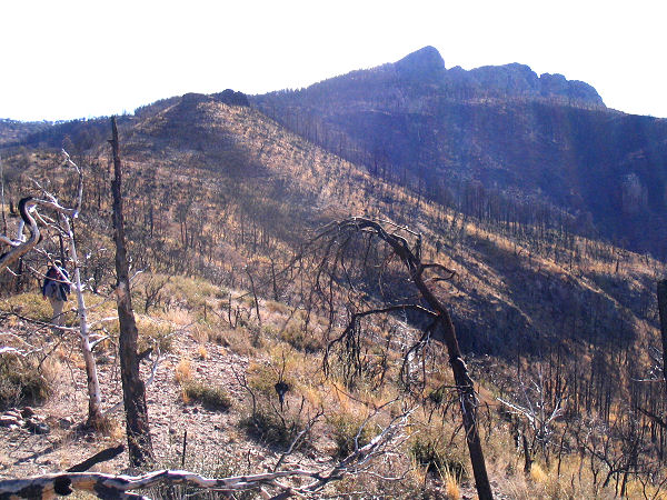
shows signs of fire damage) below the rounded
humps of Mazatzal Peak. Hike approximately 1.8
miles from the Sandy Saddle junction to a saddle
(GPS point, MP1, 6 miles, 6030 ft) where the
trail bends out and around a prominent ridge
(note: if you reach the intersection with the
right branching Davenport Trail you've gone too
far). This is the ridge you will follow to
Mazatzal Peak. Leave the trail to the left at
this point and begin following the ridge
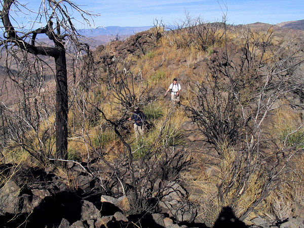
upwards. In the lower sections, the ridge is
steep and occasionally brushy (with a few
thickets of sharp thorns). As you gain elevation
the terrain becomes rockier and the ridge
narrows (the easiest route is to remain on top
of the ridge as much as possible). The walking
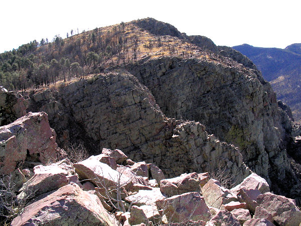
becomes easier as you enter an open pine forest,
then gain a rocky escarpment that drops steeply
away to your right with great views into the
Wilderness beyond. Continuing upwards, you will
reach the base of a prominent peak (a false
summit). You can skirt this peak on the left,
though a short, 5 minute side trip to the top is
well worth the effort (and actually has better
views than the actual summit in my opinion). The
actual peak is visible beyond, and takes another
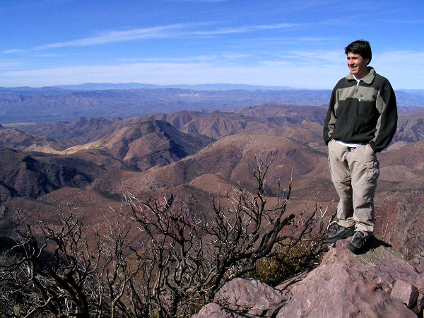
10 minutes of climbing to reach. Mazatzal Peak
features decent views in all directions and a
small register located inside of a jar and
painted soup cans (GPS point MP2, 9 miles, 7903
ft). To get back down, you can either retrace
your steps or make a loop that descends Suicide
Ridge (be aware that the latter requires some
route finding). To descend Suicide Ridge, the
first order of business is to visually identify
the route. While standing on the summit,
identify the ridgeline you just walked up on the
ascent. Looking to the right of this ridgeline,
Suicide Ridge can be seen descending to the
northeast. Note that the ridge
features a few minor humps, then
further down some steep cliff bands. Mentally
trace your route down the ridge and note that
you'll want to leave the ridge to the left
before reaching those cliffs. OK - let's do it.
Drop off the peak to the north, then skirt right
(east) to avoid some thick stands of trees. Soon
you'll be walking down a ridge with the large
cliff of the Mazatzal front range on your right
(with some good views of the valley and the
Beeline Highway below). Continue to descend
along the ridge over the minor hump of peak
7592, then down to a flat unnamed hump at GPS
point MP3. Continue down to a saddle between
point MP3 and peak 7403 (the next bump on the
ridge). Leave the ridge to the left at this
point and begin descending down a wide arm
(Note: you are basically aiming towards the
Sandy Saddle/Barnhardt Trail junction far
below). Now the tricky part - do not walk
straight down this arm, instead, work your way
to the left until you can see down into a deep
gully to the left of the arm you are on. Walk
down the arm until it begins to form an
identifiable ridge (Note: there are no steep
drop offs or cliffs along the ridge, if you find
yourself faced with a steep down climb or cliff,
you are not on the right route). The ridge
features more nasty thorn thickets as it begins
to bend to the right. Eventually the brush
abates as you descend through the burned pines
into the burned manzanita. Stay on top of the
ridge as you wind your away around the various
obstacles in your path to a point where you can
easily see the Barnhardt Trail about 200' below.
Leave the ridge to the left (GPS point MP4) and
route find down the hill through the burned
manzanita back to the trail (GPS point MP5, 12
miles, 5917 ft). Turn right on the Barnhardt
Trail and follow it the remaining 4 miles back
to the trailhead and your car (16 miles, 4220
ft). GPS Coordinates
(UTM):
MP1 = 455871mE 3771686mN
MP2 = 457405mE 3769200mN
MP3 = 458047mE 3770066mN
MP4 = 457970mE 3771848mN
MP5 = 457836mE 3771954mN |
| Rating (1-5 stars): |
 
The author completed this
loop with a group of 3 at a quick pace in 8
hours. On the descent we spent a bit of time
looking around for the correct ridge to safely
follow back to the trail. |
|
Books: |
A
slightly different route is described in:
Hiking Arizona's Superstition and Mazatzal
Country
- Grubbs,
Bruce |
|
Maps: |
Click
here for a map of this route.
Mazatzal Wilderness Tonto National Forest, USFS |
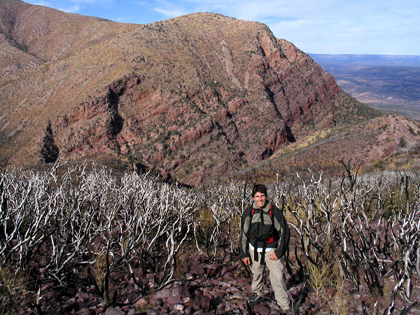
| Photos: |
Click picture for larger view, click your browser's 'Back' button to return to this page. |
|
|
