| |
Dutchman's Trail Loop - Tonto National Forest
| Summary: |
A decent loop hike
through the western part of the Superstitions. |
| Directions: |
From Phoenix, drive east
on the Superstition Freeway (U.S. 60) past Apache Junction. About
4.5mi beyond the end of the freeway at milepost 204, turn left following the
signs for the Peralta Trailhead. The road is initially paved as it heads
through a housing development, then becomes well graded dirt. At the
signed fork 5.4 miles from the highway, bear left following the sign, and continue another 2 miles to the parking area at the road's
end (complete
with an automated fee station & restroom facilities). |
| Road
Conditions: |
Passenger Car |
| Navigation: |
Moderate -
a few sections of
faint trail |
| Length: |
16.2 miles |
| Date
Hiked: |
October 2000 |
| Weather
Conditions: |
Nice - highs in the
lower
70's |
|
Required Skills: |

 |
| Hike
Description: |
Every time
I come to this trailhead it has been developed further to the point where
a Dairy Queen wouldn't really seem out of place anymore. In addition
to the housing development going up near the Rt 60 Peralta turn off, there
is now a dirt highway to the trailhead, restroom facilities and an
automated money collection machine to take that $4 entry fee off your
hands (credit cards accepted). I guess the Forest Service could
put that money to use restoring overgrazed habitat or removing cows from
heavily impacted areas or enhancing your wilderness experience but it
would be a tragedy
to put some snow bird's Lincoln Town Car at risk with a bumpy road (and
they do tend to complain more loudly than an ecosystem in decline). From the parking lot
(0 miles) head right on the Bluff Spring Trail which begins by climbing a
shoulder on the east side of Peralta Canyon. The trail then bends to
the right, and begins a series of rolling ascents/descents through one of
the prettiest sections in the Superstitions in my book (look for cairns to
the right where the trail intersects a stream bed). After 2.1 miles
(2.1 miles) you will arrive at a signed junction with the Terrapin
Trail. Those wishing to do a shorter hike may turn right and
continue on the Bluff Springs Trail which meets up with the Dutchman's
Trail a mile later (total loop distance for this shortened hike is 8.5
miles). We, however, will turn left onto the Terrapin Trail which
winds it's way beside a streambed in the shadow of Weavers Needle to the
west. The trail then climbs a short ways before descending towards
the base of Black Top Mesa. After 2.8 miles you will reach a signed
'T' junction with the Dutchman's Trail (which you will follow for the
remainder of this hike) (4.9 miles). Turn right onto the Dutchman's
Trail (a little faint in places, look for cairns where the trail passes
through horse camps) and continue 0.8 miles
along the western flank of Black Top Mesa to the junction with the left
branching Bull Pass Trail (5.7 miles). Turn right and continue on
the Dutchman Trail along a flat sandy horse trampled section past the left
branching Cavalry Trail (6.1 miles), then 1.4 miles further to the
intersection with the left branching Peters Trail (7.5 miles), along the
way you will pass a use trail leading to the left into Charlebois (locally
pronounced Charlie Boy!?) Canyon and a horse camp. Continue on the
Dutchman Trail, which continues it's path along the same wash for another
mile (look for cairns where the trail crosses the stream bed). Stay
right at the signed junction with the Red Tanks Trail (8.5 miles), the
trail then brings you into some rolling hills where you will climb a
gentle grade for a while before dropping down along a stream bed once
again. After 2.3 miles you will come to the signed junction with the
Bluff Springs Trail where you would come out if you had taken the short
cut described earlier (10.8 miles). Continue on the Dutchman as you
climb a low hill 1.2 miles to the signed junction with the left branching
Whiskey Spring Trail (12.0 miles). Continue straight as the trail
descends 1.6 miles past Miners Needle then an unnamed rock formation to
the east to a signed junction with the Coffee Flat Trail (13.6
miles). Remain on the Dutchman's Trail as you turn right and follow
the flat trail through cow trampled desert the remaining 2.6 miles to the
trail head (16.2 miles). |
| Rating
(1-5 stars): |
 
The author and his wife completed this hike in 8 hours,
stopping along the way for lunch at the Charlebois camp. This was done
on a day after two weekends of significant rain. Streams that are
normally dry were all seen to be flowing. |
| Maps: |
Beartooth Maps -
Superstition Wilderness Topographic Map |
| Photos: |
Click picture for larger
view, click your browser's 'Back' button to return to this page. |
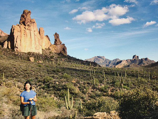 |
Rock
formation to the east
of Miners Needle. |
|
|
