| Summary: |
A cool hike
through part of the Maze with a nice pictograph panel along the way. |
| Directions: |
From
Highway 95 in Utah the entrance to the Maze is located just north of the
Hite Marina between the Colorado and Dirty Devil Rivers. Between
mile posts 46-47 turn east on a dirt road. After a short distance
you will come to a information board. Drive down this well graded
dirt road for 30 miles (stay right at the split along the way).
Note: at the 27 mile point you will pass a sign for the "Orange Cliff
Ranger District". After 30 miles you will come to a signed
4-way intersection, turn right following the arrow to Standing Rocks/Doll
House 20 miles. A short distance past this area the road begins to
roughen until you reach a "4-wheel drive only" sign near Teapot
Rock at which point it becomes down right terrible - take it slow.
After what seems like an eternity you will pass a small parking area
outlined by rocks on the left hand side. This is the parking area
for The Golden Stairs Trail. Continue on until you see a small sign
on the left for The Wall Campsite. Continue past The Wall, then
around Lizard Rock, past The Plug and Standing Rock until you reach the
finger shaped formation called Chimney Rock. Turn left following the
sign for the camp site and park near the rock. It took the author
~5.5 hours to reach this point from Highway 95. |
| Road
Conditions: |
4-Wheel Drive only! |
| Navigation: |
Moderate -
it's mostly easy, but one important turn is a little confusing. |
| Length: |
~8 miles
(some guessing here) |
| Date
Hiked: |
November,
2000 |
| Weather
Conditions: |
Cool |
|
Required Skills: |
 |
|
Hike Description: |
From the
parking area at Chimney Rock there are three cairned trails. Take
the left most trail which first heads left over some slick rock then drops
steeply down into Pictograph Fork. Follow the cairns and footprints
as you head down canyon on this flat and easy section. After ~1.5
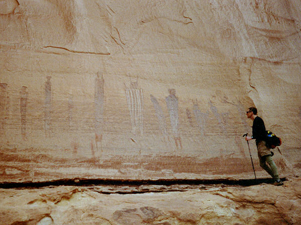
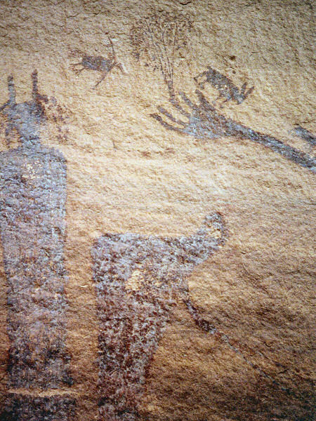
hours you will see the large pictograph panel called "The Harvest
Scene" up on the rock wall ahead of you (look and take photos, but
please do not touch). Continuing on down canyon keep an eye out for
a large drainage coming in on the right hand side. There are some
cairns which continue down canyon as well as up this side drainage.
Turn right up this side canyon (note: this turn is not terribly well
marked, if you miss it you'll continue deeper into the Maze). The
path up this canyon is somewhat faint at first with a few cairns, but
becomes easier to follow as you continue. After a while the trail
begins to climb steeply up on the right side of the drainage. When
you reach the top you will be able to spy Chimney Rock in the
distance. Follow the cairned route over the sandstone as it winds
it's way back to the trail head. |
| Rating
(1-5 stars): |

The author and his wife completed this hike in just over 3.5
hours with a stop at "The Harvest Scene" for photos. |
| Maps: |
Trails Illustrated -
Canyonlands Maze District NE Glen Canyon |
| Photos: |
Click picture for larger
view, click your browser's 'Back' button to return to this page. |