| |
Cheesebox Canyon - Cedar Mesa,
Utah
| Summary: |
A cool technical canyoneering
trip with great narrows, swimming and some
moderately challenging climbing.
To complete this canyon you will need: 150 ft of
rope (the author carried 100' of rope and a 100'
of 5mm pull cord, it is possible to complete
this canyon by performing only one 25' rappel,
but you'll have to locate all the right routes,
something I was unable to do), webbing, dry bag, harness
& descending gear. A wet suit will be required
for all but the hottest weather (the author and
his wife carried shorty wet suits, but never
wore them, day time temps were above 100 F).
Leave the bolt kit at home, this canyon does not
require bolts. All rappels may easily be done
from natural anchors.
Do not attempt this canyon if heavy rains
threaten!
Another description which does not require a car
shuttle may be found at:
Canyoneering USA |
| Directions: |
Cheesebox
Canyon is a tributary of White Canyon and is
located on Highway 95 between Natural Bridges
National Monument and Hite Marina. The canyon
drains into White at a point just below a side
road and promontory at mile marker 75 off of
Highway 95. If doing this canyon all the way
through you'll want to leave your second vehicle
here. To get to the entry point, drive on
Highway 95 to between mileposts 66 & 67, onto a
dirt road marked a short distance in by two
soldiers graves (the soldiers were allegedly
killed by indians over a dispute about stolen
horses). This road is listed as Found Mesa Road
or County Road 2271 on my Utah atlas. Veer right
just before the grave site and drive down and
across White Canyon. Drive 10.7 miles along this
fairly well graded dirt road (ok for passenger
cars if you take it very slow) and stop at a
completely non-descript spot in the juniper
dotted desert (GPS coordinates: UTM 12S 0582171
mE 4173679 mN). |
| Road Conditions: |
Passenger Car
- though it's a bumpy drive, so take it slow |
| Navigation: |
Moderate |
| Length: |
~8 miles |
| Date Hiked: |
April, 2002 |
| Weather Conditions: |
Nice in the canyon, cool in
the water, hot in the sun |
|
Required Skills: |


 |
| Hike Description: |
From the
starting point described above head due east
through the junipers towards GPS waypoint UTM
12S 0582467 mE 4173770 mN . Shortly you will see a
prominent side drainage leading into Cheesebox
proper. Route find your way down into the upper
part of this side drainage. To avoid a large
drop off into the next section of this canyon,
work your way around to the left to a point
where you can climb down. The author then hiked
directly down this side drainage and was stopped
a short ways later by a chute and 45' dry fall.
According to the web site referenced above, it
is possible to work your way down into the main
drainage without rappelling (to do this, I
believe you want to continue further to the
left, instead of going directly down the side
canyon). It was hot, the author was lazy & was
carrying plenty of rope anyway, so he rigged a
75' rappel off of a large boulder on a ledge on
the right hand side above the dry fall to land
next to a shallow pool. Continue down the
drainage and work your way out to the promontory
which separates the side drainage from Cheesebox,
you can climb down into the main canyon at this
point. You are now in a shallow section of
narrows (upstream the main canyon looks nice
also). Head down into the narrows. There is a
bit of climbing in the narrow parts of this
section and at least one chest deep wade as the
canyon opens up and closes in a few times. Soon
you will reach the first (and only required)
rappel of 25'. There is a small, but thick,
natural arch conveniently located at the top of
this drop off which makes for an ideal anchor
(you could also rig off of a large chokestone
located 15' back from the drop). It's more of
the same below the rappel (narrows, down climbs
etc.) until you come to a series of two
obstacles where large boulders have fallen into
the canyon creating drop offs. At the first one,
you can rig a 45' rappel, or better yet, have
the strongest climber in your party (preferably
someone tall) act as a human anchor for the rest
to rap off of. This last person can then climb
down to a chokestone wedged a quarter of the way
down the drop off, then chimney their way the
rest of the way down (it gets rather wide at the
bottom and you will be faced with about 25' of
exposure, so only attempt this if you feel
confident in your climbing ability (the author
completed this climb twice to show off
 ,
actually I climbed back up to help my wife down
- going up again was the hardest part). Shortly
afterwards you will be faced with a similar
boulder obstacle, with a longer ~60' drop
beneath. This time skirt the boulder pile to the
right and climb/slide down a somewhat steep
slickrock ledge to the tallest boulder wedged in
the canyon (this is a little exposed, a belay
may be desired). Climb down on the up canyon
side of the debris pile (even though it looks
like the canyon is completely blocked on this
side) and at the bottom you will find a little
hole that allows easy access to the canyon
below. The canyon slots up nicely once again and
you will have to perform a short swim followed
by a hand line assisted down climb into a water
filled narrow hallway which also requires
swimming. There is a very nice chamber and a bit
more narrows before the canyon opens up to a
long sandy, sunny slog. After slogging a while,
the canyon actually slots up at a down climb
followed by a long malodorous water filled hall
(to add to the unpleasant ambiance of the place,
the start of this pool featured the bloated
corpse of an unfortunate squirrel). If you can
stomach the swim, go for it. Otherwise, if
you're squeamish like me, climb back out of the
slot (or better yet, recognize this spot from my
description and don't climb down to begin with)
and walk around the slot on a somewhat steep
slick rock ledge on the left (there is one
tricky, steeply slanting spot on this ledge,
take care, and use the little foot and finger
crevices to your advantage). It's more wide
canyon below. If you are performing this hike as
a loop as per the web site above, look for the
Anasazi ruins and cairned route out. Otherwise
continue slogging along. After a while you will
come to another narrow section and a rather long
water filled slot that you must swim (much nicer
water than the last - watch your footing to
avoid stepping on the tadpoles!), followed by
another shorter swim. Then you're back in a wide
canyon in the sun until you are nearly at the
confluence with White Canyon. Just before the
confluence you'll hit a short stretch of narrows
and two drop offs in quick succession.
Supposedly it is possible to bypass these drops
by climbing the sandstone around on one side of
the canyon or the other; otherwise you can
rappel them like I did. The first is a 20'
rappel using a small chokestone at the top for
an anchor, the second is a 35' rappel from a
single bolt and hanger on the right. About a
minute below this drop you'll arrive at the
confluence with White Canyon. Walk directly out
of the mouth of Cheesebox across White and up a
sandy slope to some prominent cairns and a well
worn hiker trail. The path climbs up to a
sandstone layer, heads down White Canyon a ways
on that layer, then switchbacks up the other
way. You'll have to use your hands in a few
places to climb one layer or another. Soon
you'll reach the top of the mesa and you can
follow the well established use trail back to
the dirt road at the milepost 75 turn off from
Highway 95 and your second car. ,
actually I climbed back up to help my wife down
- going up again was the hardest part). Shortly
afterwards you will be faced with a similar
boulder obstacle, with a longer ~60' drop
beneath. This time skirt the boulder pile to the
right and climb/slide down a somewhat steep
slickrock ledge to the tallest boulder wedged in
the canyon (this is a little exposed, a belay
may be desired). Climb down on the up canyon
side of the debris pile (even though it looks
like the canyon is completely blocked on this
side) and at the bottom you will find a little
hole that allows easy access to the canyon
below. The canyon slots up nicely once again and
you will have to perform a short swim followed
by a hand line assisted down climb into a water
filled narrow hallway which also requires
swimming. There is a very nice chamber and a bit
more narrows before the canyon opens up to a
long sandy, sunny slog. After slogging a while,
the canyon actually slots up at a down climb
followed by a long malodorous water filled hall
(to add to the unpleasant ambiance of the place,
the start of this pool featured the bloated
corpse of an unfortunate squirrel). If you can
stomach the swim, go for it. Otherwise, if
you're squeamish like me, climb back out of the
slot (or better yet, recognize this spot from my
description and don't climb down to begin with)
and walk around the slot on a somewhat steep
slick rock ledge on the left (there is one
tricky, steeply slanting spot on this ledge,
take care, and use the little foot and finger
crevices to your advantage). It's more wide
canyon below. If you are performing this hike as
a loop as per the web site above, look for the
Anasazi ruins and cairned route out. Otherwise
continue slogging along. After a while you will
come to another narrow section and a rather long
water filled slot that you must swim (much nicer
water than the last - watch your footing to
avoid stepping on the tadpoles!), followed by
another shorter swim. Then you're back in a wide
canyon in the sun until you are nearly at the
confluence with White Canyon. Just before the
confluence you'll hit a short stretch of narrows
and two drop offs in quick succession.
Supposedly it is possible to bypass these drops
by climbing the sandstone around on one side of
the canyon or the other; otherwise you can
rappel them like I did. The first is a 20'
rappel using a small chokestone at the top for
an anchor, the second is a 35' rappel from a
single bolt and hanger on the right. About a
minute below this drop you'll arrive at the
confluence with White Canyon. Walk directly out
of the mouth of Cheesebox across White and up a
sandy slope to some prominent cairns and a well
worn hiker trail. The path climbs up to a
sandstone layer, heads down White Canyon a ways
on that layer, then switchbacks up the other
way. You'll have to use your hands in a few
places to climb one layer or another. Soon
you'll reach the top of the mesa and you can
follow the well established use trail back to
the dirt road at the milepost 75 turn off from
Highway 95 and your second car. |
| Rating (1-5 stars): |
 
Many thanks to Dave Black for volunteering to
provide a car shuttle to the trailhead!
Completing the canyon as a through trip is
greatly preferable to the road walk
(particularly on a hot day), but either way the
canyon is well worth the effort. The author and
his wife completed the hike in 8 hours after an
extended period of dry weather. Water levels may
be quite different at other times of the year. |
| Maps: |
None used |
| Photos: |
Click picture for larger view, click your browser's 'Back' button to return to this page. |
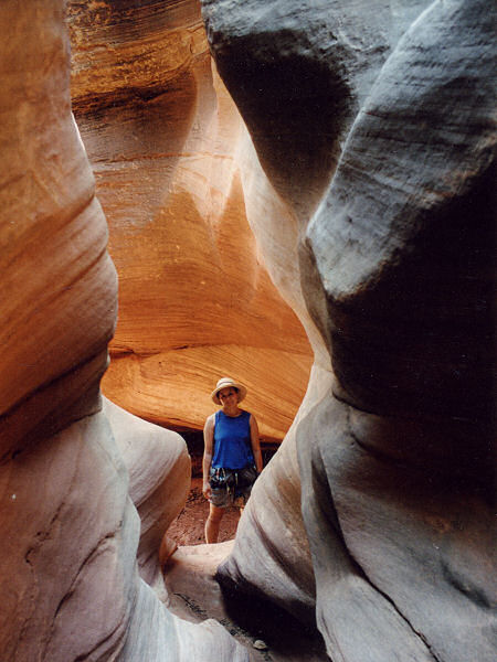 |
 |
Beginning of the
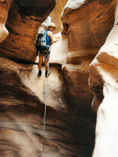
Cheesebox narrows. |
The one required rappel. |
 |
 |
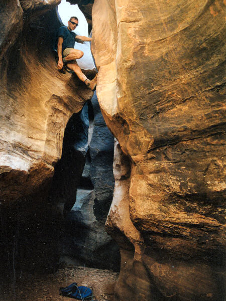
|
Boulder problem #1. |
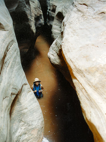
Coming out of a swim. |
|
|
