| |
Cobra Arch & the Middle Route
of Buckskin Gulch - Grand Staircase Escalante
| Summary: |
A
half day hike to an unusual and
scenic arch and the middle route of Buckskin
Gulch. |
| Directions: |
From Highway
89 between Page, AZ and Kanab, UT turn south
between mileposts 21-22 at the Paria Outpost on
the well graded, dirt Forest Road #750 (zero
your odometer here). Drive straight past the
Outpost through a few gates (leave them open or
closed, as the case may be) and soon the road
begins climbing beside Long Canyon (which looks
like it has some ok narrows). Stay left at the
road junctions at miles 4.0, 4.3, and 4.4. At
the 5.0 mile point stay straight on FR #750, the
road becomes extremely sandy beyond this point.
At the 7.7 mile point you will pass through a
fence line. Park immediately after the fence on
the right under a juniper tree near the trail
register for the Middle Route. A sign at the
trailhead reads: "Middle Route - hazardous route
ahead. This route to Buckskin Gulch includes a
steep, slippery descent from the rim into the
canyon. A permit fee is required for hiking and
overnight use in Buckskin Gulch. Please pay for
your permit at either the Whitehouse Trailhead
or the Paria contact station before or after
your hike." The gps point for
the car park is: UTM 418250mE, 4100147mN |
| Road Conditions: |
4-WD
recommended to
handle the deep sand |
| Navigation: |
Moderate |
| Length: |
~4
hours for either hike |
| Date Hiked: |
March, 2005 |
| Weather Conditions: |
Partly cloudy and cool |
|
Required Skills: |
 |
| Hike Description: |
From the car
park and trail register, begin walking south
along a sandy track beside a fence line until
you soon reach a cliff band with views south of
Buckskin Gulch and Steamboat Rock to the south
of Buckskin. Hop the fence to the right and look
for a break in the cliff band which will allow you
get down (UTM 418183mE, 4099759mN).
Cobra Arch: Route find your way to the
southeast, working your way down to the fairly
level bench between Buckskin and the cliff band
through which you just passed. Once on the bench
you may be able to pick up a moderately traveled
footpath amongst the many cow prints. As you
walk in a southeasterly direction, the cliff
band on your left will fade back into a drainage
then extend back out again. Where it extends out
you'll see an upper cliff band and a lower one.
The arch is in the lower set which means you'll
want to continue along a route that roughly
parallels Buckskin Gulch (head towards: UTM
419920mE, 4097361mN). After the route
begins to bend to the northeast and you have a
full view of a large mounded plateau off in the
distance to the east, look for the arch to the
north among a group of red rocks (UTM 420334mE,
4097568mN). Return the way you came.
Middle Route of Buckskin Gulch: Route
find your way down to the right into the most
prominent drainage heading south towards
Buckskin. Simply follow this wash down to the
edge of the canyon then work your way left
(east) across the slick rock until you find the
only route that looks even remotely possible
down into the canyon (UTM 418019mE, 4098716mN).
You'll likely find a few cairns in the area. Be
very careful on the descent (going down is much
more difficult than coming up), the route is
steep and covered with sand making footing
sketchy. Best to pass packs and provide a spot
for others in your group. Once in the canyon you
can explore up or down stream in Buckskin Gulch.
When ready, return the way you came. |
| Rating (1-5 stars): |

While the hike itself is nothing special,
the destinations are really nice. The author and his wife completed the hike
to the arch then down the middle route of
Buckskin Gulch and back in 5.5 hours. Buckskin
was flowing quickly with muddy water, so we did
not proceed down the canyon. Note: I've hiked
Buckskin and the Paria River on several
occasions, all prior to starting this web site,
so I don't have a description. I guess this will
give me an excuse to go back at some point. |
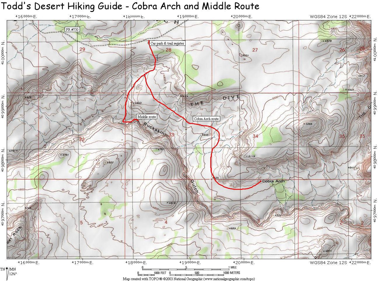
| Maps: |
Click
here for a
map of this route |
| Books: |
Hiking and Exploring the Paria River -
Michael Kelsey |
| Photos: |
Click picture for larger view, click your browser's 'Back' button to return to this page. |
 |
 |
|
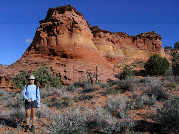
View along the way to the arch. |
Cobra Arch. |
 |
 |
|
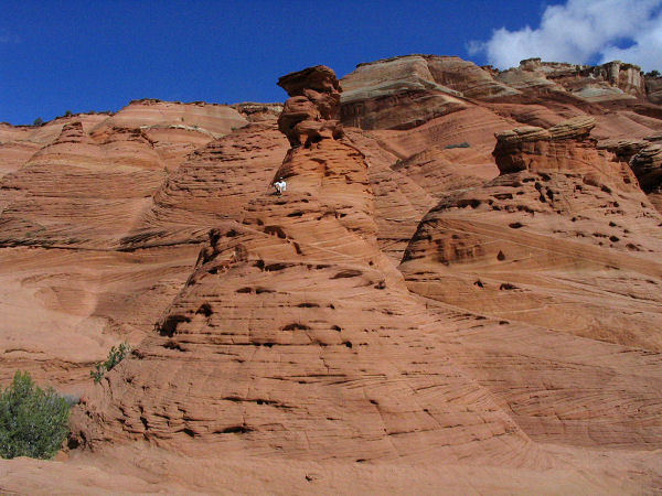
Nearby hoodoo. |
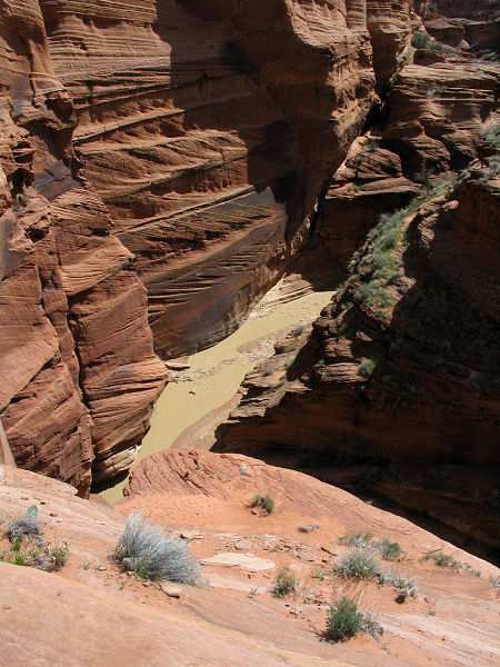
Middle route entry into
Buckskin Gulch. |
|
|
