|
Summary: |
A
two day backpacking trip to a narrow, deep and
dark technical slot canyon. Gear required:
helmet, webbing (60 ft), harness, descender,
headlamp and 2x200' ropes (or a 200' rope and
200' pull cord). A wet suit is required in
cooler wetter weather (though the canyon was dry
when I was here). This trip is suitable for
intermediate canyoneers familiar with evaluating
and using natural anchors. |
|
Directions: |
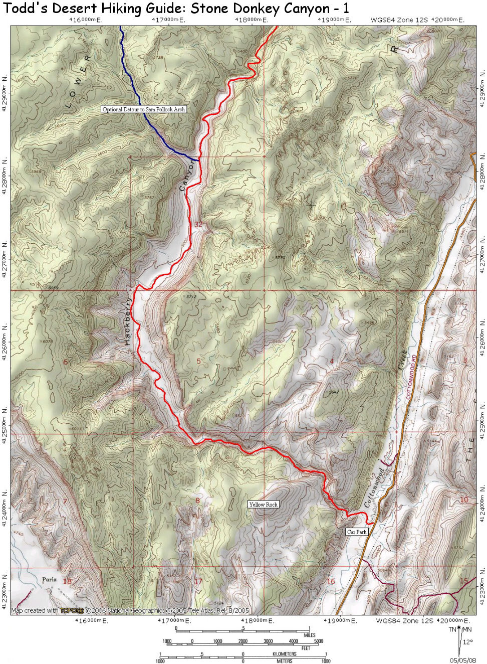
From Highway
89 between Page, AZ and Kanab, UT drive to
between mileposts 17-18 and turn north on the
well graded, dirt Cottonwood Road. Drive 14.4
miles to just past a cattle guard and right
branching Brigham Plains Road to a short pull
off on the left (west) that is the trailhead
for Hackberry Canyon. The gps point for the car
park is: UTM 419359mE, 4123741mN |
|
Hike Description: |
From
the parking area, pick up the trail that leads
down, then across Cottonwood Wash (don't bother
trying to keep your feet dry, you'll be walking
in water much of the day). Enter the mouth of
Hackberry Canyon which is found on the other
side of the wash and head upstream. The canyon
soon passes through a very pretty stretch of
narrows where the stream cuts through the
Cockscomb. Then, a short distance later, the
canyon widens as it heads
through the Chile and Moenave formations
- look for a hikers trail on one side of the
bank or the other that makes for easier walking.
About 4.5 miles up Hackberry
you'll see a prominent side canyon that enters
from the left (UTM
417342mE,
4128172mN). Those with a
little time on their hands might consider
completing a 3 mile (total out-and-back
distance) detour to Sam Pollock arch. Walk up
this side canyon until you encounter a pour off
at the top of the Kayenta formation. Look for a
trail on the right (facing up canyon) that leads
up and around this obstacle. Continue up canyon
to locate Sam Pollock arch looming above the
streambed on the right. When ready return the
way you came.
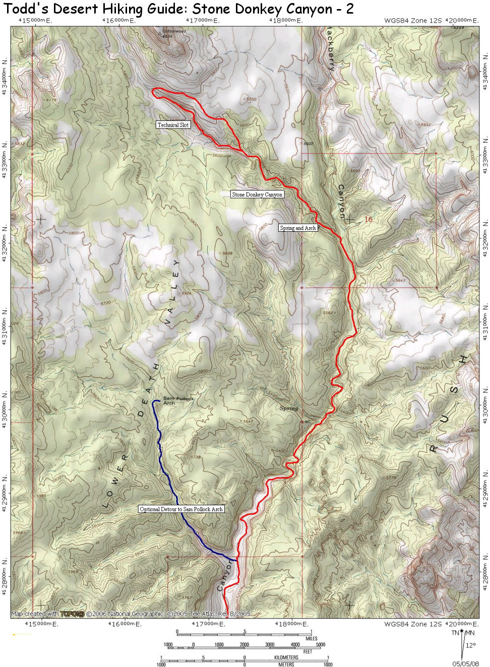
Continue up Hackberry another 3.5 miles to
arrive at the drainage of Stone Donkey Canyon,
which enters from the left (UTM
418626mE,
4131999mN). Push through the brush at the mouth
of the canyon and soon you'll reach a pleasant
spring, pool and small natural arch. Continue up
canyon another 1.5 miles to identify the canyon
narrows. Those without technical gear can
explore the narrows from the bottom. Those
wishing to see the entire canyon should
backtrack a short distance until you can
identify a break in the cliffs on canyon left
(right facing up canyon). Before heading up the
steep slope, drop your non-essential gear and
camping equipment. The canyon is very narrow and
it's advisable to travel as lightly as possible.
When ready, climb up through the break, then
begin working your way left (to the northwest)
to the slickrock bench above the canyon. If
you've made ti to the right place, Cottonwood
Butte will be above you ahead and to the right. Walk to
the head of the canyon then around to the
opposite side (right down canyon) and locate a
stout cedar tree a short distance from the head
of the canyon (and a short distance back from
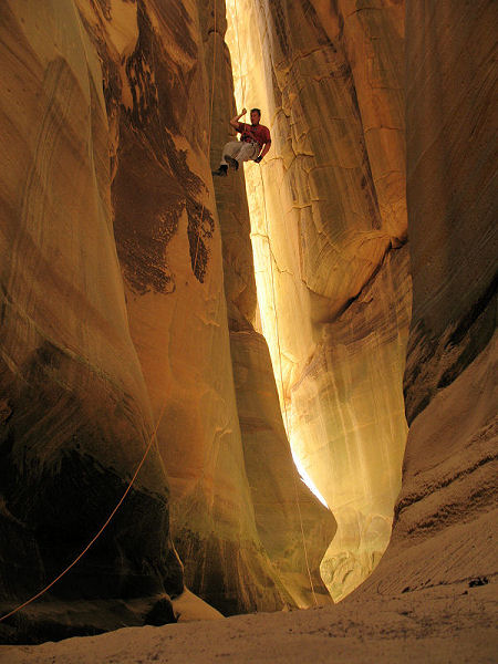
the edge). The tree is your anchor for the one
and only rappel (UTM 416407mE, 4133799mN). In order for your 200' rope to
reach the bottom, you'll need to extend your
anchor with a long piece of webbing. Rappel over
the edge and into the canyon. The last 80 feet
or so of this rap is free hanging as you drop
into a beautiful natural cathedral. Once down,
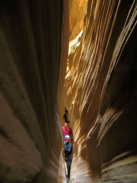
pull your rope, remove your harness and head
down canyon. The slot constricts to a narrow
crack and you'll have to turn sideways in a few
sections as you scrape between the walls. Some
wading may be required, and depending on the
time of day, you may find yourself in near
darkness (thus the headlamps). Unfortunately,
the canyon soon opens up into the wide wash and
the gear you stashed earlier.
Pick a place to camp and after a good nights
sleep retrace your steps back to your car at the
mouth of Hackberry. |

