| |
Fortymile Gulch & Willow Creek
- Grand Staircase Escalante
| Summary: |
A scenic,
non-technical slot canyon loop hike with lots of
wading (maybe swimming), great narrows and a
huge natural arch. This trip is located off of
Hole in the Rock Rd in Grand Staircase
Escalante. |
| Directions: |
From the
small town of Escalante, UT. Drive east on Utah
State Highway 12. Turn right on
Hole-in-the-Rock Road and follow to just past
kilometer post 65 to the signed Sooner Wash (UTM
494536mE, 4131438mN). There is good parking on
the west side of the road. Since you'll be
coming out via Willow Creek, you can shorten
your trip by spotting another car at one of the
Willow Creek drainages located (north to south
on Hole in the Rock Rd) at: UTM Willow 1:
496564mE, 4129565mN; Willow 2: 496398mE,
4128897mN or Willow 3 (has a small place to park
near a metal culvert): 497367mE, 4128468mN.
Note: it's a bit tricky to know which one you'll
come out on. |
| Road Conditions: |
Passenger Car
if you take it slow (except after heavy rains,
in which case you may need a 4-WD) |
| Navigation: |
Moderate |
| Length: |
11.5 miles
roundtrip |
| Date Hiked: |
May, 2003 |
| Weather Conditions: |
Nice |
|
Required Skills: |


 |
| Hike Description: |
From the car
park at Sooner Wash, walk across the road and
begin walking down the wide rocky creek bed
with a bit of brush. After 5 minutes, you'll
pass a plastic 'No Vehicles' sign and 10 minutes
later, you'll encounter a dry fall of about 50
feet. Follow the use trail on the left side of
the canyon until you can locate a place where
you can climb down (the author went in at the
first side drainage, but it requires a little
climbing; there is an easier way in further down
canyon). Once in the canyon, continue down
canyon and in another 1/2 hour or so, you'll
reach the junction with the main fork of
Fortymile Gulch (which enters from the left).
Continue down canyon and soon you'll encounter
surface water, you'll be able to keep your feet
dry for quite a while but in the end you'll be
wading, so don't expend a lot of effort. About 2
hours into the hike, you'll reach another drop
off, that can easily be bypassed by following a
trail around on the right. At the bottom of the
drop is a nice little water fall. Shortly below
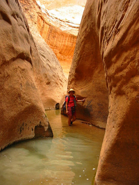
the falls, the wading begins. The canyon begins
to constrict and wall to wall pools appear. The
canyon has a number of seeps and small springs
which support ferns and plant life along the
walls and fish in the pools. Nice grottos await
around each corner, and provide quite a contrast
to the stark surrounding slick rock hills. There
are several spots where deep pools have formed.
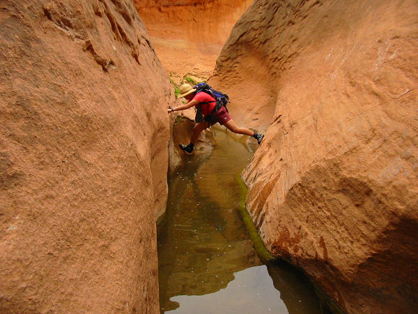
Good climbers should be able to stem across the
deepest parts (avoiding a full swim). After some
nice walking in narrows you'll reach the
junction with Willow Creek which enters from the
right. If you have some extra time to kill, like
I did, you can continue to do some exploring
down Fortymile, but the canyon is not that great
and the walking becomes a bit mushy as you near
Retention Pond Powell (let's call it what it is)
. The author walked down as far as the North
Fork of Willow Creek which enters from the left,
but this was only possible due to very low water
levels in the Retention Pond. When ready, head
up Willow Creek. It's nice enough at first, and
after about 30 minutes, you'll arrive at Broken
Bow Arch which is on the right (facing up
canyon). There are use trails on either side of
the stream bed which allow for good views and
photos. Continuing up canyon, the views become
less interesting, the water recedes underground
and the canyon walls shrink. In the upper end of
the canyon you will be faced with several
choices as the canyon splits. All roads lead
pretty much the same direction, as long as you
keep heading towards the Straight Cliffs you'll
eventually reach the road. I went right at the
first split and left at the second and came out
on Hole in the Rock at Willow 3 above. Turn
right, and follow the road back to your car. |
| Rating (1-5 stars): |
   
The author and his wife completed this hike
in a leisurely 7 hours exploring down Fortymile
Gulch as far as the North Fork of Willow Creek.
It took another hour for the road walk back to
our car. By climbing over the deepest pools, we
never went in more than knee deep. |
| Maps: |
Trails Illustrated - Canyons of the Escalante |
| Books: |
Canyon
Hiking Guide to the Colorado Plateau -
Michael Kelsey |
| Photos: |
Click picture for larger view, click your browser's 'Back' button to return to this page. |
 |
 |
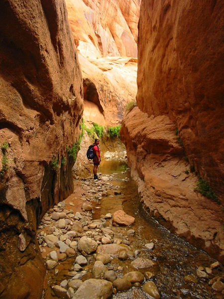
Nice, fern covered
narrows. |
Some stemming may be required
if you don't want to swim. |
 |
 |
|
Wading in Fortymile. |
Broken Bow Arch. |
|
|

