| |
Mystery Canyon - Zion National
Park
| Summary: |
Mystery Canyon is one of the
most popular technical canyons in Zion NP. You
will need a permit from the backcountry office
and there is a use restriction of 12 people per
day (which will make getting a weekend permit
difficult). Except for the unpleasant approach,
your efforts to obtain a permit will be rewarded
with some great scenery, fun rappels and the
opportunity to impress the folks hiking in the
Virgin narrows. To complete this hike you will
need:
enough rope to perform a 120 ft rappel, harness
w/ descending gear, webbing, and helmet. There
are two short & chilly swims, so a wet suit is
nice in all but the hottest weather. |
| Directions: |
Mystery Canyon lies off of
the East Mesa Trail. You can do this trip as a
loop hike from Weeping Rock or with a long car
shuttle as a through trip.
Loop hike: Take the Zion Shuttle to the Weeping
Rock trailhead. Using a map, hike up the East
Rim, then East Mesa Trails past the Observation
Point turn off to the head of Mystery Canyon.
Through Trip: From the east entrance to Zion
National Park, drive east 2.4 miles on highway
9. Turn left at onto North Fork Road and drive
5.2 miles to the Zion Ponderosa Resort. Turn
left and enter the Zion Ponderosa (stay right at
the immediate fork in the road). Many junctions
are signed and you will be heading towards
Observation Point. Drive 0.7 miles to signed
Cable Mountain, Observation Point road fork.
Turn right and drive 0.7 miles to a tee in the
road. Turn right, and drive 1.1 miles until road
forks around a large pine tree. Stay right and
drive 0.2 miles to a rough road on the left.
Turn left and drive 0.1 miles to the end of the
road and park at a fence with brown gate and
signs for 'No Hunting', 'No Biking', 'Closed to
All Vehicles' and 'Wilderness Boundary'. |
| Road Conditions: |
Passenger Car - if hiking up
from Weeping Rock
High Clearance Vehicle - if driving to the upper
trail head |
| Navigation: |
Moderate |
| Length: |
~7-9 hours |
| Date Hiked: |
September,
2003 |
| Weather Conditions: |
Warm & sunny |
|
Required Skills: |


 |
| Hike Description: |
I have not performed this
hike from Weeping Rock, so I will describe the
hike from the upper East Mesa Trailhead.
From the parking area described above, walk left
through the fence and begin hiking on the flat,
well maintained trail on the other side. After
about 10 minutes, the trail will near the edge
of a canyon which will be off to the right.
Beware -
this first canyon is NOT Mystery and has gotten
several groups in trouble! Continue hiking until
you have walked 40 minutes from your car park to
a prominent and well worn trail which extends
right from a patch of sand that is lighter in
color than the ground you have been walking on.
Walk to the canyon rim (UTM:
12 N 328943mE, 4128635mN)
and if you are in the right place you will see a
distinct trail which drops steeply down the
slope to the right into the trees below. Begin a
careful descent on this steep and loose trail
using branches, trees, roots and the few secure
rocks available to prevent and uncontrollable
slide. As you descend you will encounter several
choke stone drop offs (the first has a single
bolt and hanger for use as a belay) that you can
either down climb or bypass (on the right).
Finally the path levels out where it meets a
steep sandstone wall which will be on your
right. Continuing down canyon, there are two
more choke stone bypasses (also on the right),
one of which will cliff out if you follow the
bypass too far (you can either rappel back down
into the canyon or backtrack to find the hiking
route down). Finally, you will reach rappel #1
and the start of the fun.
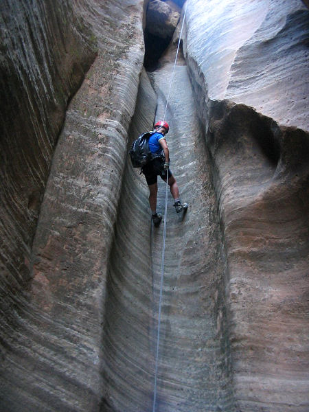
Rap #1: 50 ft from 2 bolts and hangers (B&H) on
the left, walk 60 ft to
Rap #2: 40 ft from 2 B&H on the right
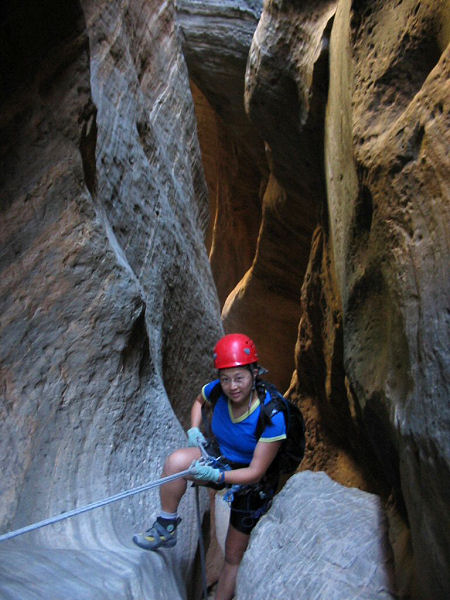
Rap #3: 40 ft from 2 B&H on the left
Rap #4: down climb a log or rap 15 ft from 2 B&H
on the right
Rap #5: down climb or rappel 50 ft from 2 B&H on
the left
The canyon then begins to open up and you will
likely be in the sun as you reach
Rap #6: 20 ft from 2 B&H on the right or bypass
with a little exposure by climbing around on the
right and down at a tree.
Rap #7: 50 ft from 2 B&H on the right
Rap #8: 20 ft from 2 B&H on the right or down
climb
This will bring you out into the sun as the
canyon widens. A 10 minute slog through the sand
will bring you to a large breakdown pile
composed of red sandstone blocks (reportedly a
small lake can form behind this rock pile during
a very wet season). Follow the footprints up and
over this hill & drop down the sandy slope on
the other side where you will encounter
Rap #9: a 50 ft sloping rappel from 2 B&H at the
top, or a sketchy down climb (I did it, but not
really recommended)
You will enter the trees after this rappel and
have to negotiate a few easy down climbs before
the canyon enters a short slot and an easy down
climb to rappel #10.
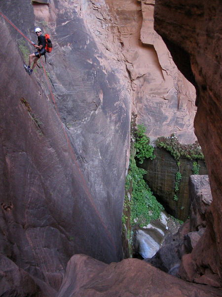
Rap #10a (recommended): is rather unique. It
involves a short traverse (a hand line will
likely be fixed here for you) followed by a 120
rap into a spring fed pool. There is a big
staging area at a choke stone on the right that
provides the perfect place to take pictures. The
rap takes you down to the top of a large choke
stone, then down into a short pool (if you're
good on rope, you might be able to get around
this pool with a short wade, otherwise it's a
full swim).
Rap #10b (the boring way): alternatively you
could rappel directly down the water course
using the large choke stone at the top as an
anchor. The rappel will take you underneath the
choke stone those performing Rap #10a land on
top of, where you will find a B&H to rappel the
rest of the way into the pool.
After pulling your ropes and gathering your
gear, continue down canyon. You will soon
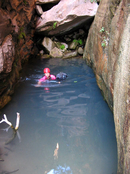
encounter the one mandatory swim in the canyon
(the second swim for those of us not clever
enough to swing around that first pool). You can
climb down into the pool on the right or simply
jump off the choke stone into the deepest part
of the pool. Beyond this, a short stroll will
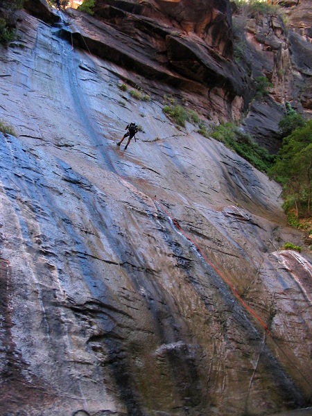
bring you to your final rappel from 2 B&H on the
left into the narrows where you will likely have
an audience of narrows hikers to marvel at your
descent (be aware that the slope you will be
rappelling is covered with algae and is quite
slick - this is your big moment, don't blow it
by falling on your butt
 ).
Ok, you're in the narrows and you've retrieved
your ropes, taken off your harness & wet suit
and stored your gear. Simply walk downstream 10
minutes to the paved path which you can follow
for another 1/2 hour to the Zion road end and
the shuttle bus stop. ).
Ok, you're in the narrows and you've retrieved
your ropes, taken off your harness & wet suit
and stored your gear. Simply walk downstream 10
minutes to the paved path which you can follow
for another 1/2 hour to the Zion road end and
the shuttle bus stop. |
| Rating (1-5 stars): |
   
The author and his wife completed this
canyon on two occasions, both times we parked at
the upper East Mesa trailhead. On the second
trip our group of 7 took 7.5 hours to complete
the hike. |
| Maps: |
Trails Illustrated - Zion National Park, Zion N.P. Park Map |
| Books: |
None |
| Photos: |
Click picture for larger view, click your browser's 'Back' button to return to this page. |
 |
 |
 |
|
Rappel #1 |
Rappel #3 |
Rappel #10 |
 |
 |
 |
|
The mandatory swim. |
The final rappel into
the Virgin narrows. |
The final rappel as
seen from below. |
|
|

