| |
Orderville Canyon - Zion National Park
| Summary: |
A nice hike through
beautiful narrows. Do not attempt this hike if heavy rains threaten. |
| Directions: |
Orderville Canyon can be
accessed from either the top or the bottom. The Park Service requires a permit to
hike this canyon, mainly to ensure no flash flood conditions exist. Permits are
available at the Visitors Center.
To access the bottom of the canyon, take the shuttle bus to the Zion
Canyon Road end.
To access the top of the canyon, drive east out of the park on route 9 for 2
miles. At mile post 46 turn left onto a paved road marked "North
Fork" towards Zion Ponderosa Ranch Resort.
After a few miles the road becomes well graded dirt. Follow the road about
11.7 miles
from route 9 to an unsigned side road on the left (there will be another road coming in
from the right with a 'V' shaped split for entrance from the east and west). Turn
left on the unsigned rough dirt road. After a couple hundred yards you will come to
a coral, a high clearance 4-WD vehicle could continue further to the end of the road and
the canyon entrance, otherwise park at the coral and walk or use a mountain bike to get to
the road end. |
| Road
Conditions: |
Bottom: Passenger Car -
paved all the way
Top: 4-Wheel Drive only |
| Navigation: |
Easy, follow the stream |
| Length: |
10 miles from the coral
to the bottom of the canyon |
| Date
Hiked: |
May, 1999 |
| Weather
Conditions: |
Cool |
|
Required Skills: |


 |
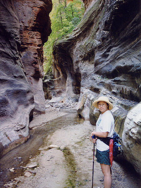
| Hike
Description: |
From the road end at the
top of the canyon, enter the canyon to the left as you work your way down into it.
Simply follow the stream bed.
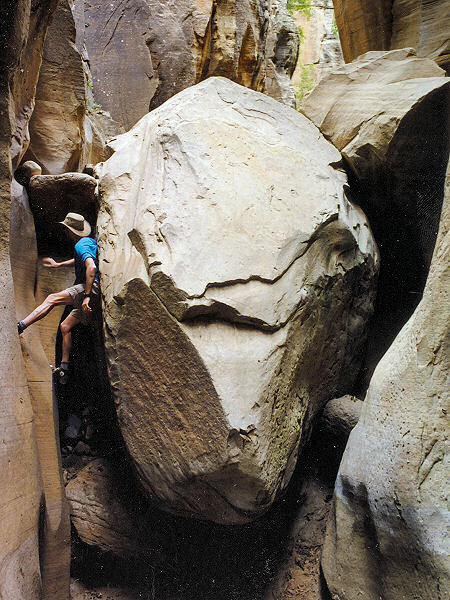
There are several drop-offs as you proceeded through the canyon, the first
is a large chokestone with a 15 foot drop-off on the other side. Good climbers can
chimney down the right side (looking downstream) between the rock and the canyon wall, but
a rope would be prudent and there is a bolt just to the left and upstream of the stone.
Never climb down something you are not sure you can get back up unless you have
a partner at the top with a rope. Climbing the chokestone on the way out is
complicated by the mud at it's base. There are several other short climbs required as you
continue through the canyon, bring 2-3 short lengths of rope just in case.
As you proceed, the canyon will deepen and eventually the streambed will
have running water in it. Towards the bottom of the canyon before it enters the Zion
Narrows there will be several deep pools which will require swimming/wading.
You can either turn around when you want or, if you have arranged a shuttle,
hike through Orderville into the Zion Narrows and down to the Zion Canyon road end. |
| Rating
(1-5 stars): |
 
A very enjoyable and photogenic hike. The author and his wife carried
one 45 ft length of rope through the canyon and didn't need it on the way down. Near
the bottom of the canyon the cold water in combination with the coolness of the day
stopped us from completing the canyon (we hiked up from the bottom the following day to
finish). The author was able to chimney the large chokestone on the way out, however
an etrier was rigged to help his wife up the drop-off. |
| Maps: |
Trails Illustrated - Zion
National Park |
| Photos: |
Click picture for larger
view, click your browser's 'Back' button to return to this page. |
|
|