| |
Tanner to Grandview - Grand Canyon National
Park
| Summary: |
A nice backpacking trip in a somewhat less visited area
of the Canyon. I describe the hike as a three day trip, some may wish to
take longer. |
| Directions: |
From Flagstaff follow US 180 northwest
until you reach the cheesy Flintstone town of Bedrock. Turn north
(right) onto Highway 64 (which is also 180) to the south entrance of the
Grand Canyon. Turn right onto Highway 64 (East Rim Drive) where it
branches off. You'll want to leave a car at the Grandview trailhead, so drive east,
following the signs to Grandview Point and park. Now you'll need to get to
Lipan Point which is about 11 miles east along the East Rim Drive. The
shuttle doesn't run in this part of the park, so your options are to: 1)
have another car and drive, 2) use a bicycle as a shuttle, 3) use the canyon
taxi service which is a total rip off at $36 for one person, or $49 for two,
or 4) try to catch a ride with a friendly tourist (note: hitch hiking is
technically not allowed in the Park, so don't blatantly walk down the road
with your thumb out, instead ask around politely to see if someone might be
willing to give you a lift). |
| Road
Conditions: |
Passenger Car |
| Navigation: |
Moderate - there are multiple braided trails along this
route, but they all lead to the same place |
| Length: |
~31 miles |
| Date
Hiked: |
March, 2003 |
| Weather
Conditions: |
Warm and sunny on day 1, then increasingly cloudy and
cooler. |
|
Required Skills: |


 |
| Hike
Description: |
Day 1 - Tanner Trail to Cardenas Creek:
There is no water along the Tanner Trail until you reach the Colorado, so
carry enough for the entire descent. From the Lipan Point parking lot, walk
back down the road a short distance to the large sign which indicates the
start of the Tanner Trail (0 miles, 7360 ft). The trail heads east a short
distance before reaching a series of fairly steep switchbacks which descend
into the canyon. Watch your footing in this section as the rock is rather
unstable. After about an hour the trail will level out somewhat at the
Esplanade and you'll walk a short ridge past the Stegosaurus Rocks to the
base of Escalante Butte with views to the left into Seventy Five Mile Creek.
The trail bends to the right (east) and begins winding it's way around the
butte along a path that is considerably more level (though there are a
couple short climbs and descents). Looking up to the right as you hike,
you'll be able to see the Watchtower (a Mary Colter design, built in 1932 as a view point and gift
shop, $0.25 per person to climb to the top of the tower). Once around
Escalante Butte the trail crosses a tributary of Tanner Creek then
continues around Cardenas Butte eventually reaching a break in the Redwall
Limestone that will allow you to continue your descent. There are more
steep switchbacks along a loose rocky path as you make your way through
the Redwall, then a short descent through a drainage to a spot on the
Bright Angel Shale. The path bends left and levels out for a short
distance as it winds its way along a ledge then begins dropping once again
through the remainder of the BA Shale to the Dox Sandstone (a very dark
brownish red sandstone prevalent in this area). From this point you'll
have great views of the river and Tanner Delta below you. The trail winds
its way down along the side of a steep slope (watch your step, if you slip
it might be a ways before you stop sliding) before eventually leveling
out. From there it's easy walking down to the creek bed of Tanner Canyon.
Follow the cairns down the creek bed and shortly you'll come to a well
defined trail which leads off to the right (leads to the Beamer Trail,
campsites and toilet). Ignore this path, and continue in the creek bed to
the river. The Escalante Route begins on the left just before reaching the
Colorado. Turn left and walk through the sand along the river (8 miles, 2700
ft). The path soon climbs a few log stairs up to a bench. It's easy, flat
walking as the trail winds its way along the bench 2.5 miles to Cardenas
Creek. You'll be able to recognize Cardenas since: 1) it's the third major
drainage after leaving Tanner, 2) there's a rounded hill just on the other
side of the creek bed, 3) the path is flat - if you start climbing, you've
gone too far. Walk down the creek bed almost to the river & look for a use
trail on the left. There are many good camp sites beneath the trees and on
the beach (10.5 miles, 2700 ft).
Day 2 - Cardenas Creek to Red Canyon: The path begins directly across from
the spot where the trail entered Cardenas Creek (0 miles). Begin climbing on
this path and soon the trail splits; it doesn't matter which one you take.
The left trail is fainter & climbs steeply up to the top of a low hill to an
Anasazi ruin, before dropping down the other side to connect with the main
trail once more. The right path is easier walking and simply contours around
the hill at a gentle grade (a third route exists which climbs up from the
river below on the right, you'll see this track from your vantage point on
the hill). Which ever route you take, you'll find yourself ascending at a
moderate grade towards an un-named drainage to the west. After a bit of
climbing, you'll hit a nice view point which overlooks Unkar Delta on the
opposite bank (there are ruins on the delta, but I couldn't spot them). The
trail rounds the head of the un-named drainage, then begins contouring
around the steep slope of the hills on the other side. You'll have to do one
steep, but short, climb to get around another minor drainage before the path
levels off and winds across a rocky slope. The path in this section is a bit
faint in spots (because it's often on the rocks), but not difficult to
follow. There are two routes you can now take to get to your next
destination in Escalante Canyon. The manly, if pointless, route is to
abandon the trail and hike straight up the slope towards an obvious break in
the cliff band above you. You can then slide down a scree slope on the other
side of this notch into the east fork of Escalante. The other route is to
simply stick to the trail and hike out and around the cliff band. The
established path is easy and pleasant, so that's the way I went. Following
the trail, when you reach the point of the promontory you have been
skirting, the path becomes faint. Simply walk down the arm of the promontory
towards the river about 100' or so, and look for cairns and the trail to set
off again to the left. This path begins a gentle descent as it heads into
the east fork of Escalante Canyon. After crossing the drainage you'll skirt
a low hill, before dropping into a gully. Follow the gully down until you
reach the creek bed of the west fork of Escalante. Hike down canyon and soon
the path jumps out of the wash on the left to skirt a minor drop off. Follow
the path as it winds back down into the canyon, which you'll follow to the
Colorado River. Your next destination is Seventyfive Mile Canyon. When the
river is running very low, you can simply walk along the edge of the river
into the canyon, but you'd be missing the best part of the entire hike.
Instead, pick up the prominent trail on the left that begins just before the
river and follow it as it climbs moderately along a ridge (you'll see the
band of rock you're climbing on mirrored on the other side of the river).
The path heads down river a short distance then bends left and heads along
the deep slot that is lower Seventyfive Mile Canyon. The trail heads up this
canyon to a spot where you can climb down into the canyon (do not contour
around the canyon even though there is a trail). There is an easy 12 foot
down climb at the top, then you'll walk right down this nice, deep slot
(note: the Park Service description, written over 11 years ago, mentions the
possibility of a chest deep wade in this section, I suspect the depression
in the canyon floor that could form such a pool has long since filled in
with gravel, I'd be very surprised if you encounter such a pool). A few easy
climbs will bring you, all too soon, to the river once again. Your next
destination is Papago Canyon, and again you have a choice. Follow the trail
on the left, which climbs up onto the cliff band before dropping onto the
Papago Delta, or follow the river. Unless the river is very high, just walk
the river bank. When you get near the canyon, another use trail climbs up on
the left to avoid an outcrop of rock. I was able to stay at river level the
entire way. Once on the Papago Delta, you'll find that the mouth of Papago
Canyon is blocked by a 25' dry fall. If you have time, you may want to climb
around and check out the little slot above. When ready, your next task is to
get to Red Canyon. You can try walking down the beach, but unless the river
is very low, chances are your path will be blocked by an outcropping of
rock. Instead, begin climbing the ledges immediately on the down river side
of the mouth of Papago Canyon. You'll have to use your hands to get up, but
it's not terribly difficult. Follow the cairns up around a corner and you'll
see Red Canyon in the distance. Unfortunately, you now have to drop down an
annoyingly steep scree slope to get down to the river level again. Pick up
the trail at the bottom of the slope and follow this level path west to Red
Canyon - there are some nice campsites under the trees (7.5 miles).
Day 3 - Red Canyon to the Rim via the Grandview Trail: Your path begins by
walking west along the Red Canyon Delta (don't climb the big sand dune, it
just leads to erosion). You are now on the Tonto Trail and it begins by
gradually ascending the rocky hillside beside the river (0 miles, 2608 ft).
Because of the rocks, the path is somewhat faint in places, keep your eyes
peeled for cairns. After climbing a ways, your route west will be blocked by
the drainage of Mineral Creek. The trail bends south and winds its way up
the drainage to a spot where it can cross, then continues west and begins
climbing moderately across a few minor drainages below the steep redwall
cliffs of Ayer Point. After rounding a bend, your path west will be blocked
once again, this time by the large drainage of Hance Creek. The trail is
flat and easy as it heads south once again up to a point where it can cross
the creek (there are some good campsites just down stream of where the trail
crosses the creek). After climbing out of the creek bed, the path continues
out along the opposite bank to an unsigned and not terribly well marked
junction. The right branch is the continuation of the Tonto Trail; we will
head left and begin climbing up, over a low hump, to climb beside a minor
drainage (6.2 miles, 3760 ft). Once the path crosses to the other side of
this drainage it begins climbing like it means business. Soon you'll reach a
rusty wheelbarrow and a sign for Page Spring. The spring is very nice and is
a short walk down the left branching path. When ready, continue your steep
climb up to the base of the redwall, then along side of it, to an old mine
(you'll see evidence of what the miners were looking for in the green rocks
that dot the ground). The path continues past the mine and continues its
steep ascent through a break in the redwall to the top of Horseshoe Mesa (10
miles, 4800 ft). Trails branch off every which way on the mesa due to the
many backpackers that frequent the area (though I'm not quite sure why,
since it's dry, crowded and littered with rusty cans, and mining crap). Stay
to the left at all junctions and you'll soon find yourself heading up on the
left of the large drainage of Cottonwood Creek, you are now on the Grandview
Trail. The path climbs moderately beside the canyon, all the way to the
headwall, where it begins climbing in earnest once again. You'll climb
steeply up to a saddle with views down into the upper reaches of Hance
Creek, then you'll negotiate some tight switchbacks and before long (and all
to soon) you'll reach the rim and your car (13 miles, 7400 ft). |
| Rating
(1-5 stars): |
 
The author and his wife completed this hike as a 3 day backpacking trip at
a leisurely pace.
Hike times were 6.5 hours from Tanner to Cardenas Creek, 7 hours (with lots
of dawdling) from Cardenas Creek to Red Canyon, 8.5 hours from Red Canyon to
Grandview. There was a bit of snow near the rim coming down Tanner, but it
had mostly melted by the time we hiked out. |
| Maps: |
Trails Illustrated -
Grand Canyon National Park |
| Books: |
None used. |
| Photos: |
Click picture for larger
view, click your browser's 'Back' button to return to this page. |
 |
 |
|
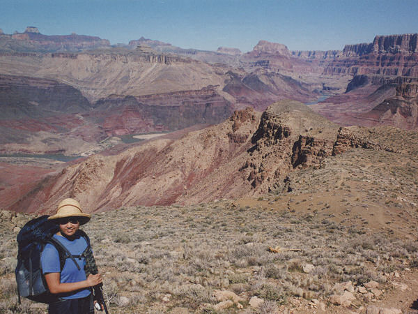
| Descending the Tanner Trail. |
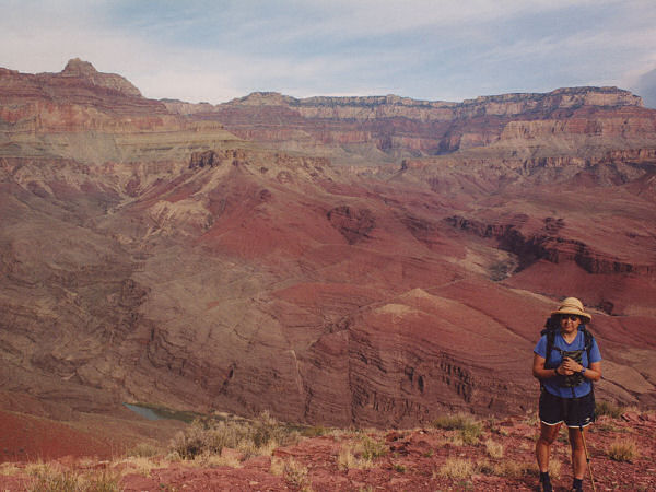
Hiking west of Tanner. |
|
 |
 |
 |
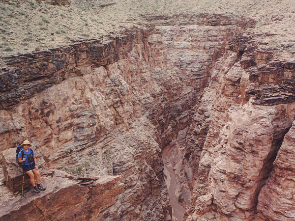
Overlooking Seventyfive
Mile Canyon narrows. |
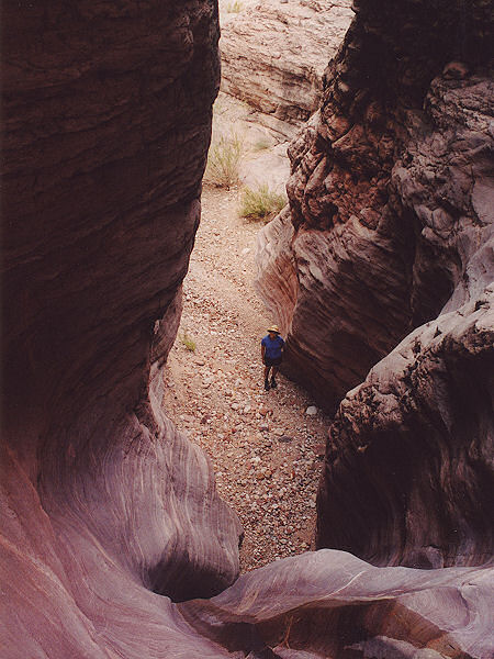
Seventyfive
Mile Canyon. |
Looking down from
Papago Canyon. |
|
|
