| |
Snake Gulch - Kaibab National Forest
| Summary: |
A flat hike through a wide canyon with
many pictograph panels and a few petroglyphs and ruins. Please remember
that the Antiquities Act prohibits destruction or removal of artifacts.
Please look and photograph, but do not touch (oils in the hand can hasten
the demise of pictographs) or disturb these sites. |
| Directions: |
From
Flagstaff drive north on Highway 89. Turn left on Highway 89A and
drive to Jacob Lake. Head south on Highway 67 for a couple hundred
feet then turn right on Forest Road (FR) #461. Drive 5.4 miles to the
intersection with FR #462 and turn right. Drive 3.2 miles to the
intersection with FR #22 and turn left. Drive a few miles until you see a
wooden horse corral and the right branching FR #232. Turn right and follow
this road to the parking area at the end. |
| Road
Conditions: |
Passenger Car - dirt roads are well
graded |
| Navigation: |
Easy |
| Length: |
~14 miles round trip to the ruins and
back, though the turn around point is arbitrary |
| Date
Hiked: |
November, 2001 |
| Weather
Conditions: |
Nice |
|
Required Skills: |
None |
| Hike
Description: |
From the sign post for the
Snake-Kanab Trail, Kanab Creek Wilderness follow the well established
trail as it heads through a wide valley. After 10 minutes you will see the
remains of an old stone cabin off the the right and the canyon bends left.
The trail throughout this hike is much the same - the canyon is wide and
sunny, the trail is flat, well established and lined by black bush,
russian thistle, and tall grasses (given the fall weather when the author
was here, it was very much like walking through a dried plant exhibit).
This canyon was obviously once heavily grazed and is still showing
considerable damage as a result. Just past the cabin you pass an old
register then the Kanab Creek Wilderness - Kaibab National Forest boundary
and a short distance later, a fence with gate and stile. About 45 minutes
into the hike you'll pass through another fence and just past that, you'll see a
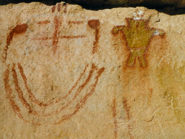
fenced in alcove on the right. The alcove contains a good petroglyph panel
and a few pictographs. Continuing down canyon, after another 15 minutes
you'll come to another fence and gate. After that, you'll spot a pictograph panel on the
right. From there just follow the trail, there are many pictograph panels
and all appear to have use trails that lead up to them. Some of the panels
are so faded they are just smudges, while others are quite well preserved.
The panels become better and more detailed as you head down canyon and you
will find some which include yellow, white and black in addition to the
typical dark red colors. If you want good photos I would suggest bringing
a camera with a zoom lens, some of the panels are fairly high on the wall
(I wish I had brought one). In the upper part of the canyon all the panels
appear to be on the right side, as you get lower they begin to appear on
the left side as well. Eventually you will reach the point where Table
Rock Canyon (there is an old green metal tank just inside Table Rock
Canyon is you have any doubts where you are) comes in from the left and
the remains of a fence line cross the main drainage of Snake Gulch. There
is an alcove on the right wall at this junction which contains ruins -
nothing remains but a few little walls however. Below this point the
pictograph panels fade away and it's fairly boring walking. Later, (if you
haven't turned around already) you will pass a coral and another fence;
the canyon bends left and about 10 minutes later, look for a large alcove
up on the right hand wall. This alcove contains some nice ruins with
walls, fire pit, pot shards and corn cobs (!please! - tread with care and
do not disturb this site). This was the turn around point for the
author.
|
| Rating
(1-5 stars): |
 
While the hiking part of this walk is not all that exciting, the
pictograph panels and ruins make for a pretty interesting day. The author
and his wife spent 5 hours hiking down to the ruins described above,
stopping frequently and making detours for views of the pictograph panels.
We returned to our car in another 3 hours for a total walk time of 8 hours
(in case you are math challenged). |
| Maps: |
Trails Illustrated -
Grand Canyon National Park |
| Books: |
Canyon
Hiking Guide to the Colorado Plateau -
Michael Kelsey |
| Photos: |
Click picture for larger
view, click your browser's 'Back' button to return to this page. |
 |
 |
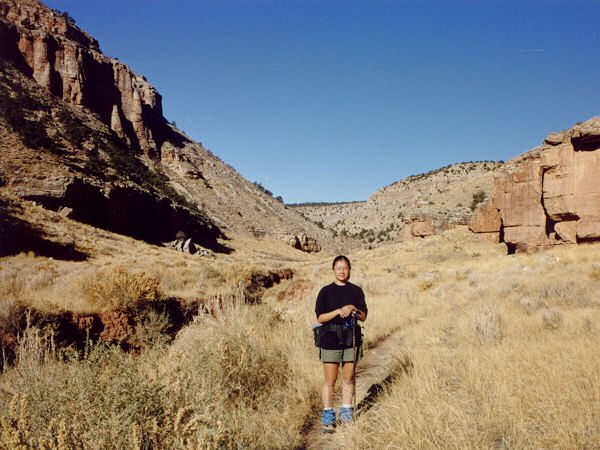
| All of Snake Gulch looks
just like this. |
Pictograph panel. |
|
|
