| Summary: |
A flat, easy hike on a multi-use trail
(bikes & horses) though Ponderosa pine forests, meadows and Aspen groves
with views into the Grand Canyon. The path winds it's way between 5
viewpoints. You can hike any section as an out and back or multiple sections
with a car spot. |
| Directions: |
From Flagstaff drive north on Highway 89.
Turn left on Highway 89A and drive to Jacob Lake. Head south on Highway 67
for 26.5 miles and turn right on Forest Road (FR) #22 (sometimes listed as FR
#422). Drive 10.5 miles and turn left on FR #206.
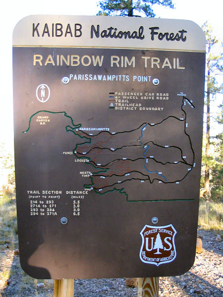
Parissawampitts: From FR #206, drive 3.5 miles and turn right onto FR
#214 and follow it 8 miles to the Parissawampitts Viewpoint and trailhead.
Fence: From FR #206, drive 5.0 miles and turn right onto FR #271. Go
0.1 miles and turn right onto FR #294, drive another 0.1 miles and turn
right onto FR #293 and follow it ~8 miles to the Fence trailhead.
Locust: From FR #206, drive 5.0 miles and turn right onto FR #271. Go
0.1 miles and turn right onto FR #294 and follow it ~8 miles to the Locust
trailhead.
North Timp: From FR #206, drive 5.0 miles and turn right onto FR
#271. Go 5.0 miles and turn right onto FR #271A and follow it 3 miles to the
North Timp trailhead.
Timp: From FR #206, drive 5.0 miles and turn right onto FR #271 and
follow it 8 miles to the Timp trailhead. |
| Road
Conditions: |
Passenger Car - dirt roads are well
graded |
| Navigation: |
Easy |
| Length: |
18 miles one way for the entire trail,
though many shorter hiking options exist.
Parissawampitts to Fence = 5.5 miles
Fence to Locust = 3.0 miles
Locust to North Timp = 6.5 miles
North Timp to Timp = 3.0 miles |
| Date
Hiked: |
October, 2004 |
| Weather
Conditions: |
Sunny and cool |
|
Required Skills: |
None |
| Hike
Description: |
I will describe the hike from
Parissawampitts walking southeast to Timp. From the Parissawampitts
trailhead and sign walk down the rocky path a short distance (making a
detour to the viewpoint if desired) and turn left at the brown plastic trail
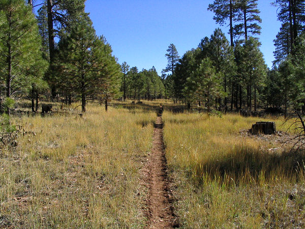
sign. The path is flat and easy walking the entire way and easy to follow as
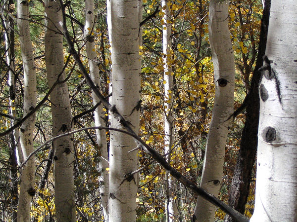
it winds through Ponderosa Pine forests, grassy meadows, and Aspen groves
with occasional oaks in the shallow side drainages. The coarse follows the
north rim east, but it leaves the rim frequently to contour around the many
side drainages that lead into the Canyon. There are nice viewpoints at each
of the road ends that you pass along the way. My least favorite section was
between Locust and North Timp. The Forest Service has logged many trees in
the area and there are stumps and slash piles everywhere. The path becomes
nicer again between North Timp and Timp. |
| Rating
(1-5 stars): |
 
This is a nice fall hike with the oak and aspen leaves changing color. The
author was dropped off at the
Parissawampitts trailhead and walked the entire trail to Timp at a fast pace
in 5.5 hours. |
| Maps: |
Kaibab NF map available at the Kaibab Plateau Visitor
Center located in Jacob Lake. |
| Books: |
None |
| Photos: |
Click picture for larger
view, click your browser's 'Back' button to return to this page. |