| |
Superstition Mountain Ridge Hike - Tonto National Forest
| Summary: |
A tough hike along the ridge line of the
Superstition Mountains starting at the Siphon Draw Trailhead and ending
near the Peralta Trail at the Dacite Cliffs, with some of the best views
anywhere. A car shuttle is required for this hike.
!Warning!: Please do not
underestimate the difficulty of this hike. Once you reach the ridgeline the
only safe way down is at one end of the trail or the other. The ridge line
is rugged and the path is faint. This hike should only be attempted by fit
and experienced hikers who set out with an early start. If you have any
doubt regarding your ability to complete this hike in a day, bring enough
equipment, water and food to bivouac for the night. As there are no trail
signs, a map and navigational aids (that's code for a compass or better yet
a gps with several sets of spare batteries) are a necessity. See map
suggestion below or obtain a copy of the USGS quad for the area before
setting out. |
|
| Directions: |
You will need two cars for this one way
hike. Park one at Lost Dutchman State Park and the other at the Dacite
Cliffs (high clearance vehicle) or Lost Goldmine Trailhead (parking here
will add a 1/2 hour road walk to the end of your hike).
Lost Dutchman State Park: From Phoenix drive east on Highway 60 to
Apache Junction. Take the Idaho Rd. exit and head east on State Highway
88 (keep an eye out for where 88 turns right at a light). Just past the
fake and commercial Goldfield Ghosttown you'll see a large sign for the park on the
right. Turn right into the park, stop at the rangers station and pay the $5 per
carload entry fee and pick up a map of the area. Following the map you
just received, continue past the rangers station and take your first right
(signed for Siphon Draw) and follow this road around the camping area,
staying to the right, to the small parking area at the Siphon Draw
Trailhead (better get here early, there are spaces for only a few cars).
Dacite Cliffs or Lost Goldmine Trailhead: From Phoenix, drive east
on the Superstition Freeway (U.S. 60) past Apache Junction. About
4.5mi beyond the end of the freeway at milepost 204, turn left following the
signs for the Peralta Trailhead. The road is initially paved as it heads
through a housing development, then becomes well graded dirt. At the signed
fork 5.4 miles from the highway, bear left following the sign, and continue 0.6 miles to an unsigned road on the left. Those
with a high clearance vehicle can follow this road a short ways to it's
end at a red neck camp (tire tracks, broken bottles, fire rings etc.). You
will be completing this hike by descending the prominent draw just to the
left of the Dacite Cliffs. Otherwise you could continue another 0.8 miles
down the road from this turn off and park at the signed Lost Goldmine
Trailhead. |
|
| Road Conditions: |
Passenger Car to Siphon Draw or Lost
Goldmine Trailheads, High Clearance Vehicle to the Dacite Cliff parking
area. |
|
| Navigation: |
Moderate - there are some very faint to
nonexistent sections of trail along this hike, however, because your route
is the ridgeline it's hard to get lost. |
|
| Length: |
~9.5 miles? |
|
| Date Hiked: |
December 2001 |
|
| Weather Conditions: |
Nice & cool, but quite breezy &
chilly along the ridge |
|
|
Required Skills: |

 |
| Hike Description: |
From the Siphon Draw Trailhead, begin following the wide and rocky Siphon Draw Trail #53 towards the front range of Superstition Mountain. After a short stroll you'll pass through a couple fences before reaching the Tonto National Forest Boundary. All trails are signed and well marked in this area, stay (straight) on Trail #53 at any junctions. Vegetation in the area is typical of the Upper Sonoran Desert: mesquite, jojoba, brittlebush, prickly pear, creosote bush,
paloverde, saguaro & hedgehog cactus etc. The trail becomes steeper as it begins to climb towards the draw. As you get higher you will find that some well intentioned imbecile has taken it upon
themself to spray paint white dots & arrows to mark the path. Excuse me while I digress for a moment: it breaks my heart to see evidence such as this of vandalism in wilderness areas. While this behavior is likely illegal, it is certainly wrong and incompatible with a wilderness experience. Please do not bring this ignorant behavior into the wilds with you, if you are concerned about someone losing their way placing a few cairns would better serve the public. For those that can not find their way without spray paint, simply hike elsewhere. OK - enough said, back to the hike. The well trodden tail climbs steeply up to slick rock chute, continue up the rock. At the top, numerous use trails make the path a little confusing. Look up above you and you'll see the huge rock outcropping of Flat Iron - the trail passes up a draw just to the left of this prominent formation. To stay on the trail simply head up the draw that leads in that direction (there are really only 2 draws in the upper part of this canyon, stay in the one on the right). The trail becomes more distinct again as you continue higher. It also becomes an extremely steep climb requiring the use of your hands in many spots. Just before you reach the summit, you'll see a well defined trail heading off to the right, this leads to the top of Flat Iron (a great lunch stop if this is your destination). At the top of the hill you can look for a cairned use trail that heads off to the left - this leads to the summit of Superstition Mountain. We, however, will continue straight through the hoodoos on a well defined path. The trail descends between the hoodoos to a camp site (stay right at the camp), then bends left to get around a large unnamed canyon. From this point you'll see the entire Superstition Ridge laid out ahead of you. You'll be headed past the big mountain in the distance with the hoodoos on top. Once around the canyon the trail bends right again and becomes somewhat faint and narrow, follow the cairns to stay on the right track, and keep your eyes open for the many cholla and agave that line the path so you don't get stuck. The trail basically follows the ridge eastward. You'll have good views at first to the south of the valley and later spectacular views to the north into the heart of the Superstitions & Weavers Needle. There are several peaks lined up one after the other. Typically some climbing is required to get down to the shoulders between the peaks, then back up the other side. Be careful of the rock when climbing, it is fairly loose and crumbly (I received a 3" gash on my leg when a large section of rock gave way). The path doesn't go over the very top of each peak, typically it heads along the northern slope and avoids some climbing. The trail is fairly well cairned and visible, though you can probably expect to waste some time trail hunting as you go. Along the ridge you have much the same vegetation as down below (though more sparse), with the addition of sugar sumac,
bursage, smoketree, yucca, and beargrass. When you reach the saddle at the base of the large peak with the hoodoos, you will see a cairned path heading south (right) down the hill and another which continues straight along the south slope of the mountain. Continue straight along the slope. The trail is more distinct at this point as it travels over some boulders for a ways before bending left and climbing steeply towards a gap in the hoodoos you may have noticed earlier. From the gap the trail climbs up to the summit of the mountain before descending the other side then traveling along the northern slope of the ridge. The path becomes easy to follow as it drops down a scree slope to a saddle, then climbs a low hill before bending to the left and descending the left side of the hill. You then traverse a ridge then descend steeply into the drainage of Boulder Canyon. Once in the canyon the trail bends right and heads towards a gap (more spray paint marking the way at this point, even though the trail itself is quite clear). From the gap you'll be able to see the road to Peralta Trailhead and the road to the Dacite Cliffs. The trail descends steeply down the rocky draw, with a brief saddle as your only respite. The path levels out when you finally reach the bottom of the
drainage. Follow the trail southwards to the wilderness boundary, through a stile to the road. If you've parked at the Dacite Cliff road end (described above) your trip is done. Otherwise you have a ½ hour walk out to the road
which leads to the Peralta Trailhead, then head left to the Lost Goldmine parking area.
|
|
| Rating (1-5 stars): |

The author and his wife completed this hike in 7 ½ hours, then
spent another ½ hour hiking back to our car at the Lost Goldmine parking
area. Our experience may or may not be typical, other people have
reported needing 10+ hours. |
|
| Maps: |
Beartooth Maps -
Superstition Wilderness Topographic Map |
|
| Photos: |
Click picture for larger
view, click your browser's 'Back' button to return to this page. |
|
 |
 |
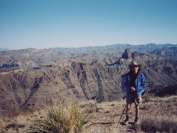
Heart of the Superstitions
from the ridge line. |
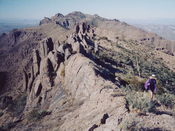
Looking back along the
ridge. |
 |
|
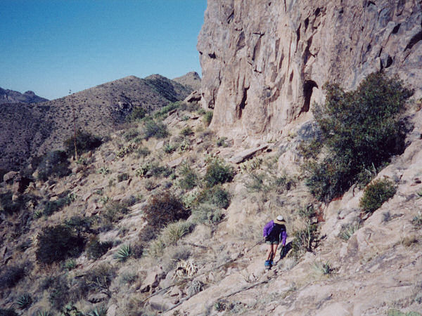
| Rounding one of the ridgeline peaks. |
|
|
|
