| |
Rogers Trough Loop #1 - Tonto National Forest
| Summary: |
A decent loop
hike in the central Superstitions with indian
ruins along the way. The loop uses the Reavis
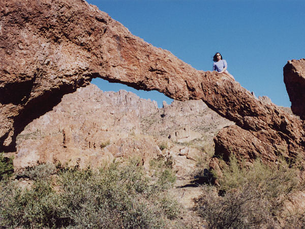
Ranch, Rogers Canyon, and JF Trails. A small arch located in
Hewitt Canyon is also described. |
| Directions: |
From Phoenix drive east on Highway 60
1.8 miles past Florence Junction and turn left
on Queen Valley Road. Drive another 1.8 miles
and turn right on Hewitt Station Road (Forest
Road #357) which immediately becomes well
graded dirt. Drive 3 miles and turn left onto
FR #172 at a brown sign pointing the way to
Superstition Trailheads: Woodbury 11 miles,
Rogers Trough 12 miles. After several miles
the road crosses a dry stream bed then begins
traveling through a high walled canyon. Keep
an eye out on the left hand side in this area
for a small natural arch (featured in David
Meunch's AZ photo book). After 9.3 miles you
will reach a sign for the Woodbury Trailhead
1.5 miles left, Rogers Trough 3 miles to the
right. Stay right on FR #172A and drive the
remaining 4 miles (not 3 as the sign
indicates) up this rather steep road to the
large parking area and trail head. |
| Road Conditions: |
High
Clearance Vehicle |
| Navigation: |
Easy, one
tricky turn, just follow the trail description
below |
| Length: |
11.5 miles |
| Date Hiked: |
February 2002 |
| Weather Conditions: |
Warm with a
good breeze |
|
Required Skills: |
None |
| Hike Description: |
The trail
starts between the two rust brown posts at the
end of the parking lot. After about 5 minutes
you'll come to a signed junction with the
right branching Pinto Trail (0.2 miles),
continue straight on the Reavis Ranch Trail
(#109). The sunny trail descends gradually
between low hills beside the dry streambed of
Rogers Canyon, sometimes climbing up on the
side, before dropping back down to the wash
(watch your footing on the descents as the
trail consists of loose gravel & is
slippery in places). Typical vegetation in the
area includes: prickly pear, sugar sumac,
juniper, agave, manzanita, scrub oak,
ponderosa pine, utah serviceberry, and cotton
wood. After about 1/2 hour of walking you will
reach a sign for the Reavis Ranch Trail (1.5
miles) pointing ahead and back the way you
came and a new Rogers Canyon sign pointing
left. Turn left at this sign on
the Rogers Canyon Trail (#110) which continues
down Rogers Canyon. It more of the same as you continue
down canyon. In the lower part of the canyon,
shortly after passing a rocky section of trail
which travels right down the stream bed, watch
for a prominent use trail on the right which
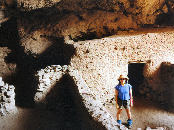
leads up the hill to some shallow caves and
the well preserved indian ruins (also
described in my Reavis
Ranch Hikes write up). Please obey the
faded sign which urges you not to climb or
walk on the ruins (particularly the small
granary). Most people will probably use this
as their turn around point - if you are one of
them I suggest you investigate the ruins then
take your break in the dry stream bed below,
so others can spend a few minutes with the
ruins alone. We, however, are ready for more
hiking and less people, so we'll continue down
canyon to Angels Basin (a wide and grassy area
with many good campsites - 4.2 miles). In
Angels Basin you will reach a signed junction
with the right branching Frog Tanks Trail
(#112), stay straight on the Rogers Canyon
Trail which now begins a moderate ascent
beside a shallow wash. The trail reaches a
shoulder (with good views to the right) then
bends left and continues climbing up to
Tortilla Pass (5.8 miles). You drop down a
short distance on the other side and shortly
reach a signed junction with the JF Trail
(#106) which heads right and straight.
Continue straight on the JF Trail as it
descends moderately steeply on a rocky path.
When you eventually reach the valley floor,
the path meanders up a series of shallow
washes past a Superstition Wilderness boundary
sign to a shiny metal windmill and small stock
pond with piped spring (which had a small
trickle when the author was here). This area
has been decimated by the cattle which you
will see lounging in the shade of the scrawny
trees around you. Follow the cairns and in a
few minutes you'll reach the signed junction
with the Woodbury Trail (#114) (8.3 miles).
The Coffee Flat Trail is one mile to the right
and FR#172A is one mile to the left. Head left
and follow this old jeep track steeply up to
the junction with FR#172A (9.5 miles). Turn
left and follow the road the remaining 2 miles
back to your car, keeping a close eye out for
trucks tearing around the blind corners (11.5
miles). |
| Rating (1-5 stars): |
 
Between the photo of the ruins in Arizona
Highways and the fact that a once rough road
is now passable by the most roll over prone
SUV, the Rogers Trough area has become overrun
with hikers, hunters and boy scouts. On this
trip the author counted 20 cars at the
trailhead and over a dozen people at the
ruins. Sort of a shame as this significantly
detracts from the experience (for me
anyway). The author and his wife
completed the loop in 7 hours at a moderate
pace, wasting a 1/2 hour by missing the turn
at the Reavis Ranch Trail sign and heading up
Grave Canyon a ways before realizing our
mistake. |
| Maps: |
Beartooth Maps - Superstition Wilderness Topographic Map |
| Photos: |
Click picture for larger view, click your browser's 'Back' button to return to this page. |
 |
 |
| The
little arch in Hewitt Canyon. |
The
well preserved ruins
near Angels Landing. |
|
|

