| |
Reavis Falls - Tonto National Forest
| Summary: |
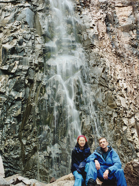
A surprisingly large gushing waterfall
right in the heart of the Superstition Wilderness. This one is a
real gem if it's flowing. I learned of this hike through the HikeArizona
web site. They have a pretty good write up and trip description,
though the length of the hike is over inflated in my opinion (they list it
as 17.5 miles, I'm guessing it's more like 13 or 14). |
| Directions: |
From Phoenix take US 60
east. Exit at Apache Junction and drive northeast on State Highway 88. Follow
88 to the end of the pavement (about 25 miles) then a few miles further until the road
begins a steep decent into the canyon. Once in the bottom continue
driving until you see the sign for Reavis Ranch on the right hand
side. Turn right and follow this somewhat steep, but smooth and well
graded road to the trailhead at the end. |
| Road
Conditions: |
Passenger Car |
| Navigation: |
Moderate: mostly easy to follow trail,
but since there are no signs I'm rating this moderate. |
| Length: |
~12 miles |
| Date
Hiked: |
January 2001 |
| Weather
Conditions: |
Chilly - highs in the
mid 50's with fog, rain, sleet, sunshine, hail, snow then more rain, then
the sun came back out, then the clouds rolled back in, then ...........
you get the picture. |
|
Required Skills: |

 |
| Hike
Description: |
From the
signed trailhead begin hiking up the Reavis Ranch Trail on a smooth well
graded path as it ascends moderately into the rolling hills of the eastern
Superstitions. After about 2 miles you will reach a small pass after which
the trail becomes somewhat rockier, though still ascends at the same
moderate grade. This portion of the hike passes through grassy rolling
hills up towards Castle Dome, the pyramid
shaped mountain you see off to the right. Keep an eye on the left hand
side (east) for a very distinct use trail (possibly marked with cairns)
heading up the hill. The author arrived at this trail one hour after
starting the hike. Turn left onto this unmaintained trail, though it is
really in great shape and quite easy to follow for its entire length (it's
actually in much better shape than many of the supposedly maintained
trails in the Superstitions). The trail climbs moderately upwards, passing
through a gate to a saddle, then begins descending down the other side.
For the next hour the trail descends eastward at a moderate to steep grade
down towards the drainages you see far below you. Supposedly there
are some Indian ruins about 1/2 mile down from the saddle, but the author
searched and did not find them. Upon reaching the bottom the trail bends
left and follows the stream bed a short ways passing across a small patch
of poured concrete (in case you're not sure you are in the right place
here's a landmark). The trail then crosses the stream (Lime Spring if you
have your map handy), climbs a low hill then drops down the other side to
the next drainage over (this one is Reavis Creek). Cross the creek then
turn right and head upstream. In the first couple hundred yards you will
pass some rather well established camp sites on creek right. The trail
then fades somewhat just past the campsites, though there are lots of
cairns marking the easiest routes as you rock hop, and bushwack your way
upstream. About 40 minutes from the campsites you will come to
Reavis Falls. The falls are about 140 feet tall and cascade over a rough rock wall into a shallow pool below. This makes for a nice lunch spot. When
ready, return the way you came. |
| Rating
(1-5 stars): |
   
The author and his wife completed this hike at a leisurely pace in about 7
1/2 hours, stopping quite a few times to adjust clothing to compensate for
the ever changing weather. It had rained considerably the day prior to our
arrival (and quite a bit the day of our hike for that matter) which must
have fed the falls as they were flowing strongly. |
| Maps: |
Beartooth Maps -
Superstition Wilderness Topographic Map |
| Photos: |
Click picture for larger
view, click your browser's 'Back' button to return to this page. |
 |
| Reavis Falls |
|
|

