| |
Picketpost South on the AZ Trail - Tonto National Forest
| Summary: |
A long out and back hike
through the desert along the AZ Trail starting
at Picketpost Mountain near Superior, AZ and
heading south.
Caution:
This is a long and rather remote hike that
requires good route finding skills. I have done
my best to describe the more confusing sections
of the route, but the responsibility for your
safety is your own. Good luck! |
| Directions: |
From Phoenix,
drive east on route 60 towards the small town of
Superior. Drive 0.5 miles past mile marker 221
and turn right (south) on Forest Road (FR) #231
(look for the aluminum windmill to the south).
Drive 0.4 miles to a signed junction with FR
#310. Turn left, remaining on FR #231, and drive
0.6 miles to the huge Picketpost parking area,
complete with bathrooms and hitching posts. |
| Road Conditions: |
Passenger Car |
| Navigation: |
Difficult |
| Length: |
~25
miles or just turn around when you want |
| Date Hiked: |
December 2004 |
| Weather Conditions: |
Sunny, chilly and breezy |
|
Required Skills: |

 |
| Hike Description: |
From the parking lot, pick up
the Arizona Trail which begins just behind the
large gate and sign for (what else?) the AZ
Trail. Follow this dirt road as it winds its way
through the desert to the south of Picketpost
Mountain. After about 20 minutes the road
splits, look for the wooden AZ Trail posts that
mark the route to the left. Vegetation is
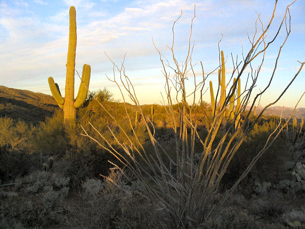
typical Sonoran Desert with saguaro, ocotillo,
palo verde, jojoba, prickly pear, and cholla.
The path begins climbing then drops down and
enters a series of washes, which it then follows
for some distance. Keep an eye out for cairns
and where the wash splits look for rocks that
have been placed as barriers. Occasionally the
route will pick up a short stretch of road or
trail, before dropping down into the wash once
more. After approximately 70 minutes of brisk
hiking (my pace, your time may vary) you'll
reach an old aluminum wind mill and tank
(waypoint #3) next to a dry wash. There was a
paper sign on the mill when I was here which
indicated that water was available by detouring
450' down the wash to a piped spring (I walked
down to this pipe and it was not flowing, so
don't count on it). Continuing along the trail
from the mill, the path eventually leaves the
wash and climbs through some low hills before
topping out at a prominent forest road (not sure
what road this is though). Turn left (following
the AZ Trail posts) and begin walking along the
road. At first, whenever the road forks, the AZ
Trail is marked with a signpost. Unfortunately
these route markers are discontinued and are
replaced by somewhat less distinct cairns.
The first confusing junction comes where a spur
road joins the road you are following from
behind you on the right (waypoint #6). Stay
straight on the main road at this junction.
Shortly afterwards the road climbs a small rise
and splits. A short distance up the hill on the
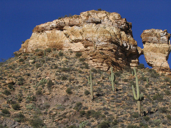
road to the right is an interesting mine, the
trail (and cairns) however are to the left
(waypoint #7). Turn left. Continue following the
road checking for cairns at any junctions. The
road becomes somewhat fainter the further you go
and eventually enters a dry wash. Look for
cairns marking an abrupt right turn up another
wash (waypoint #8) at which point the road
becomes more distinct and begins climbing. Near
the top of the climb the road passes through a
fence and there is a brown plastic AZ Trail
marker on the right side of the road which will
confirm that you are on the right track
(waypoint #9, it took me 3 hours of fast walking
to reach this point). The road goes down and up
a few hills then drops into another wash which
it follows for a ways before bending right (look
for cairns, waypoint #10) and shortly thereafter
bends left (waypoint #11) leaving the wash at an
AZ Trail signpost. The path is rather faint at
this point as it climbs through some rounded
hills, but is marked by cairns at frequent
intervals (check carefully). After a bit of
climbing the trail tops out at a shoulder marked
by an old fence (waypoint #12). Hike across the
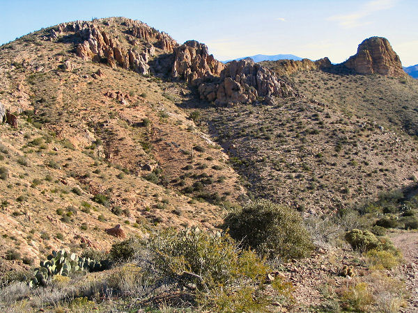
shoulder and down a series of washes on the
other side through extremely nice desert scenery
(this is the best section of the hike). As you
descend you'll pass a few signs marking the
boundary of a wilderness area which is closed to
motor vehicles, motored equipment, bicycles and
hang gliders (of all things). The path continues
to descend becoming more faint as it goes. Take
your time locating the many small cairns that
mark the route, especially over the rocky
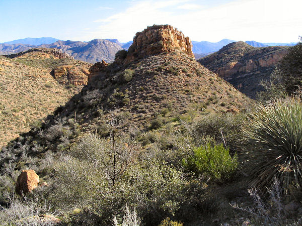
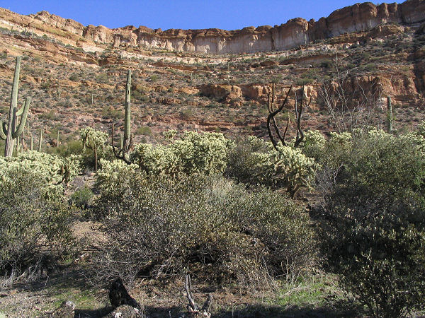
sections. The path bends right and passes
beneath a colorful escarpment which will be on
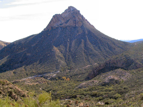
your left as it heads towards a prominent
triangular shaped mountain peak. Eventually the
path picks up an old unused road which it
follows the remainder of the way to the base of
the triangular peak ending at a fairly well used
dirt road (again I'm not sure which forest road
this one is). If you've made it this far
(waypoint #13), then you know it's time to turn
around. Return the way you came.
GPS waypoints
for this hike in order from north to south (for
reference purpose only):
#1 = UTM 483506mE, 3679696mN
#2 = UTM 484135mE, 3678493mN
#3 = UTM 484059mE, 3677083mN
#4 = UTM 484087mE, 3676192mN
#5 = UTM 484524mE, 3674854mN
#6 = UTM 485999mE, 3674173mN
#7 = UTM 486106mE, 3674101mN
#8 = UTM 486952mE, 3673732mN
#9 = UTM 486635mE, 3672934mN
#10 = UTM 487455mE, 3672309mN
#11 = UTM 487470mE, 3672272mN
#12 = UTM 488248mE, 3671401mN
#13 = UTM 491410mE, 3669097mN |
| Rating (1-5 stars): |
 
I'd probably give this hike a better rating,
except for the fact that I'm not terribly fond
of walking on forest roads. The latter portion
of the hike is quite good though it takes quite
a bit of
effort to see. The author completed this hike
solo at a fast pace, getting off the trail a few times
and taking time to explore an arch and old mine,
in 10 hours. |
| Maps: |
Maps of the hike:
Map 1,
Map 2,
Map 3 |
| Photos: |
Click picture for larger view, click your browser's 'Back' button to return to this page. |
|
|
