| |
Seven Springs Recreation Area,
Inner Trails - Tonto National Forest
| Summary: |
The Seven Springs Recreation
area is located just north of the town of Cave
Creek. Be aware that this is a fee area ($4 per
carload per day). This report describes a
shorter 10 mile loop hike using the Skunk Creek
Trail and a longer hike (~20 miles) using The
Skunk Creek, Quien Sabe and Skull Mesa Trails.
I'm not sure about the mileage of these hikes as
the numbers on the trail signs often didn't
match the amount of time it took to hike a
section of trail. Take them for what they're
worth. |
| Directions: |
From Phoenix,
drive north on I-17 to exit #223 and head east
on the Carefree Highway. Drive all the way to
the end at a 'T' intersection and turn left on
Tom Darlington Dr. and follow it a few miles
until it ends at Cave Creek Rd. where you'll
turn right. You'll pass a small airport on the
left and further down the road, Desert Mountain
(also on the left). Where the road splits,
you'll see a sign for Bartlett Lake & Rangers
Station to the right; you'll want to stay left
(this is Forest Road 24). Shortly afterwards
you'll pass a sign for Seven Springs, Sears Kay
Ruin, Camp Creek, Residential Area. After 2
miles you'll enter the Tonto National Forest. At
the 4.5 mile point the pavement ends in a well
graded dirt road. Continue winding along the
road, at the 12 mile point you'll hit a short
stretch of pavement as you enter the Seven
Springs Recreation area and Cave Creek
Campground (there is an
electronic self service fee station in the
middle of the road when you enter the area.
). Drive past the
camp sites & look for a green 'Trail' sign which
points to a parking area (with bathroom) on the
left side of the road. |
| Road Conditions: |
Passenger Car |
| Navigation: |
Moderate - the path is
generally easy to follow and all trail junctions
are signed, but there are a few faint sections
of trail |
| Length: |
~10 miles -
Skunk Creek loop
~20
miles - the hike as described |
| Date Hiked: |
January 2005 |
| Weather Conditions: |
Cloudy and cool |
|
Required Skills: |
 |
| Hike Description: |
Just to give you a feel for
the semi-loop described below, open up the
map in another
window and follow along. From the Cave Creek
Trailhead we'll take trails 4 > 247 > 246 > 250
> 248 (left) > 247 (right) > 248 > 250 > 246
(left) > 4 (right) > Cave Creek Trailhead. So
off we go - from the Cave Creek
Trailhead pick up the Cave Creek Trail #4 as it
travels behind the campgrounds paralleling the
road. The path crosses a dirt road (ignore the
unsigned junction on the left, and remain on
#4) and drops down beside Cave Creek to a junction
with the left branching Cottonwood Trail #247.
Turn left on #247 which crosses the stream then
climbs a hill to the junction with the Skunk
Creek Trail #246 which branches right. Turn
right on the Skunk Creek trail and follow this
old road as it soon begins climbing moderately
steeply through the hills in an area mainly
consisting of scrub oak, juniper and sugar
sumac. The path eventually bends right and
levels off, traversing the side of a hill until
you reach the junction with the left branching
Quien Sabe Trail #250 (which means 'who knows'
in Spanish in case you're interested). The sign
indicates you've come 3 miles on the Skunk Creek
Trail, but I'm guessing it's more like 1.5
miles. You may continue straight on the Skunk
Creek Trail for a shorter loop, we'll turn left
however, on the Quien Sabe Trail, which begins
climbing gradually on another old road. The path
reaches a small shoulder, then drops down along
a somewhat faint path (marked with cairns) with
some nicer views. Eventually the path drops down
and crosses a small stream bed, and climbs out
the other side to soon join the Skull Mesa Trail
#248 at a 'T' junction (sign says 2 miles each
way to the Cave Creek Trail #4, I'd say it's
more like 1.5 miles left and 2.5 right). Turn
left on the Skull Mesa Trail which winds its way
through some desert scenery, climbing gently
until you reach a fence, at which point it
begins descending steeply from the mesa to the
'T' junction with the Cottonwood Trail #247.
Turn right on the Cottonwood Trail which follows a ridgeline down to a
wash, becoming more rocky as it goes, and
entering lower desert with saguaro and jojoba.
Once in the wash, the path is somewhat faint;
simply walk down the wash.
After passing a corral, it climbs up and over a
low hill on the right to follow another wash. After passing another
corral, the path bends right then begins climbing
moderately towards some white outcropping of
rock on the edge of Skull Mesa. As you enter an
area with dirt of a dark brown color, the path
becomes somewhat faint as it climbs the rocky
hillside in an area which exhibits the
characteristics of overgrazing. Look for small
cairns which lead up to a shoulder which is
divided by a fence and contains a signed
junction with the other end of the Skull Mesa
Trail which heads right). Turn right on the
Skull Mesa Trail which climbs moderately to
steeply straight up the hillside towards the
mesa above. As you get closer to the top, the
path negotiates a series of switchbacks until it
eventually reaches the top of the mesa. The
trail then bends right and winds its way along a
level path through a grassy area dotted with
basalt boulders. There are supposedly some old
rock walls from ancient Indian dwellings in the
area, but I did not see them. I did see several
large flocks of small birds which covered the
mesa and made quite a racket. Eventually the
path reaches the edge of the mesa and descends
along a steep path to the junction with the
Quien Sabe Trail. Turn left and follow the Quien
Sabe Trail back to the Skunk Creek Trail. If
you've come this far and are tired the shorter
way back to your car is to turn right on the
Skunk Creek Trail and return the way you came
earlier. If you still want to hike some more,
turn left on the Skunk Creek Trail which
descends moderately through a series of hills to
arrive at a gate and stock pond. The path then
bends right and begins descending moderately
along the right hillside above the deep 'V'
shaped drainage of Skunk Creek. The trail
descends more steeply as you drop down into the
drainage of Cave Creek and the junction with
(what else?) the Cave Creek Trail #4. The sign
also indicates that the Cave Creek Trailhead is
5.5 miles straight, which is incorrect, the
distance is closer to 3 miles. Turn right on the
Cave Creek Trail as the path bends right to
follow a flowing stream on one side of the bank
or the other. Look for a good example of a
crested saguaro when the trail is traveling
along the left hillside above the stream bed.
After passing this cactus, the path drops down
and crosses the stream bed, travels on the right
hillside for a while, then descends to stream
level, following a wide flat track through the
riparian vegetation to the junction with the
right branching Cottonwood Trail you had taken
earlier. Continue straight the remaining
distance back to your car (~20 miles).
|
| Rating (1-5 stars): |

A nice long desert hike which is nice enough,
if a bit rocky. The author, realizing he'd left
his headlamp at home, walked fast the entire way
to avoid getting stuck out after sunset
completing the hike in just under 8 hours. |
| Maps: |
Tonto
National Forest Map or Click
here (note: I
reproduced this this map by copying the sign the
Forest Service placed at the Cave Creek
Trailhead. It is only as accurate as the Forest
Service made it.) |
| Photos: |
Click picture for larger view, click your browser's 'Back' button to return to this page. |
 |
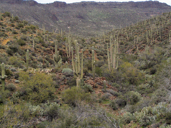 |
Desert vegetation along the
Skull Mesa Trail. |
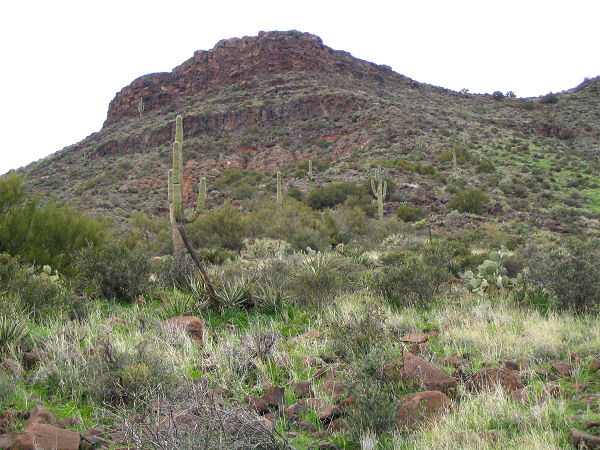
Skull Mesa from the
Cottonwood Trail. |
 |
 |
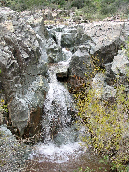
Waterfall along the
Cottonwood Trail. |
The climb up to Skull Mesa. |
|
|
