| Summary: |
A stroll
through a land of weird and interesting rock
formations. Several short day hikes within the
park are also described. |
| Directions: |
Drive along Highway 24
which runs between I-70 to the north and
Hanksville to the south. Near mile post 137
head west on a paved road following the signs
for Goblin Valley State Park. After a few
miles the road continues straight and branches
left towards Goblin Valley. Follow the
signs for Goblin Valley. There is a
rangers/fee station just before you enter the
Park. Cost is $4 per carload or $12 to camp
(note: the campsite has potable water and
solar showers which are for campers only -
though if your desperate, sneaking a shower is
a definite possibility
 ). After you pass the rangers station you'll come to a 'T' intersection. Turn right to go to the campground, left to go to Goblin Valley or pull forward and park to hike the Curtis Bench Trail. If you turn left you'll come to a parking lot with covered picnic area and rest room. ). After you pass the rangers station you'll come to a 'T' intersection. Turn right to go to the campground, left to go to Goblin Valley or pull forward and park to hike the Curtis Bench Trail. If you turn left you'll come to a parking lot with covered picnic area and rest room. |
| Road Conditions: |
Passenger Car
- paved all the way |
| Navigation: |
Easy |
| Length: |
Various |
| Date Hiked: |
October, 2001 |
| Weather Conditions: |
Cool and
sunny |
|
Required Skills: |
None |
| Hike Description: |
Goblin
Valley:
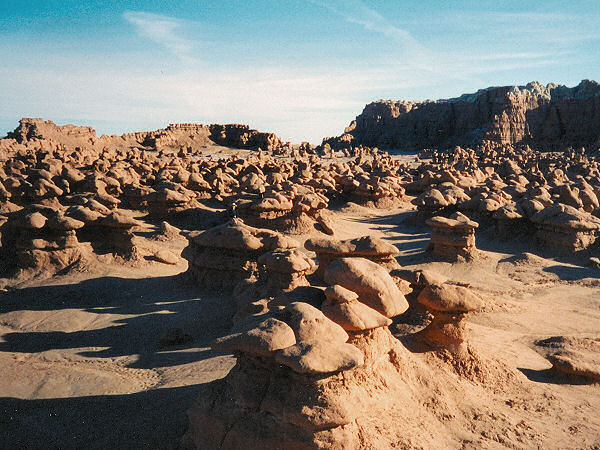
From the picnic area, simply follow the foot prints down into the valley. You are free to wander at will through the sandstone figures. Here's an explanation of the formations from the interpretive sign: "The unique and mysterious Entrada rock sculptures known as goblins have been hidden or in the making for 150 million years. Because of the uneven hardness of this layer of sandstone, some patches resist erosion better than others. When the softer material is removed by wind and water thousands of unique geologic goblins emerge." and: "The goblins are made of Entrada sandstone. They consist of debris eroded from former highlands and redeposited here on a tidal flat (alternating layers of sandstone, siltstone and shale). The goblins show evidence of being near an ancient sea with 1) the ebb and flow of tides, 2) tidal channels that directed currents back to the sea and, 3) coastal sand dunes. Joint or fracture patterns within the Entrada sandstone beds created initial zones of weakness. The unweathered joints intersect to form sharp edges and corners with greater surface area to volume ratios that the faces. As a result, the edges weather more quickly producing spherical shaped goblins."
Carmel Canyon Trail:
This trailhead is located to the left as you pull into the picnic area. The trail forms a 1.5 mile long loop and is a little difficult to follow in places (look for the blue painted cairns and a few signs with arrows). About half way through, you'll be following a dry creek bed. Where it intersects another wash look for a small wooden arrow on the left where this wash cuts back. You can also head right and follow the wash towards Molly's Castle if you'd like a closer view, but this is not a maintained trail. The trail ends in the road a short distance from the picnic area, turn right and walk the road back to your car.
Curtis Bench Trail:
Begins at the 'T' intersection and runs 2.1 or 3 miles (depending on the source) to the Henry Moutains Lookout. The author has not hiked this trail.
Entrada Trail:
Begins just behind the rest rooms and leads 1.5 miles to the campground. The author has not hiked this trail. |
| Rating (1-5 stars): |
 - for the goblins since they are so unique
- for the trails; the one the author hiked was not very
interesting
The author and his wife wandered through the
goblins for an hour and a half, then walked
the Carmel Canyon Trail in about 45
minutes. |
| Maps: |
USGS: Goblin
Valley (1:24,000) |
| Books: |
Canyon
Hiking Guide to the Colorado Plateau -
Michael Kelsey |
| Photos: |
Click picture for larger view, click your browser's 'Back' button to return to this page. |