| |
Cable Mountain - Zion National
Park
| Summary: |
A rather
uninteresting hike to a historic site with
incredible views.
|
| Directions: |
Drive to the east entrance to
Zion National Park. Just inside the entrance
follow the 'Trail' sign located on the north
side of the road a short distance to the parking
area and trail head. |
| Road Conditions: |
Passenger Car |
| Navigation: |
Easy - all trails are signed |
| Length: |
16 miles |
| Date Hiked: |
September,
2002 |
| Weather Conditions: |
Hot and sunny |
|
Required Skills: |
 |
| Hike Description: |
From the
parking area next to a corral (5720 ft, 0 miles),
walk past the gate to the start of the East Rim
Trail where a metal sign reads: Cable Mountain 8
miles, Deer Trap Mountain 9 miles, Weeping Rock
10 miles. The path is flat, wide, and sandy as it
winds it's way past juniper, oak, and pine. The
trail heads moderately up the drainage of Cave
Canyon a ways before negotiating a big
switchback. It then bends right and begins
climbing up on the left side of Jolley Gulch
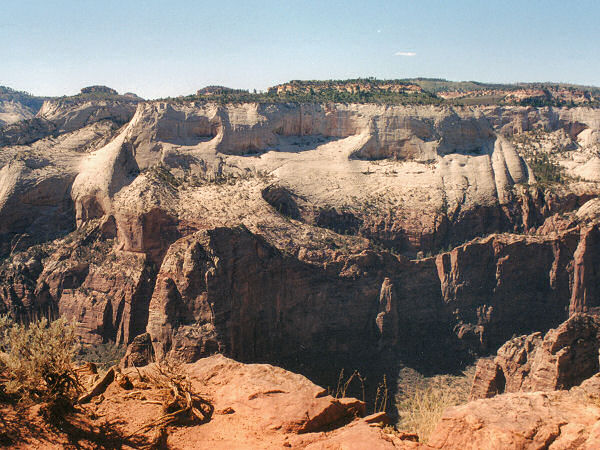
above the white cliffs. The path then passes by
the head of Jolley Gulch marked by a sign and
big drop off, then continues it's climb on the
slope above the other side of the drainage.
After the trail completes another long
switchback, the forest thickens somewhat and
shade becomes more abundant. Continue climbing
at a moderate grade until you finally reach the
top of the mesa and relatively level ground
(6730 ft). The path then descends moderately to
a short spur trail leading to the piped Stave
Spring (dry when the author was there). Continue
a short distance past the spring to a signed
junction (6435 ft, 5 miles) with the left
branching Deer Trap Mountain Trail (Cable
Mountain 3 miles, Deer Trap Mountain 4 miles).
Turn left on this trail (more of a footpath than
the road you have been following) and once again
begin climbing moderately through the woods.
After another 45 minutes or so, you'll reach a
signed junction with the left branching trail to
Deer Trap Mountain - stay right towards Cable
Mountain. The path soon tops out (6900 ft) then,
as it begins descending moderately, you'll
finally catch glimpses to the right of the
cliffs of Zion Canyon. You'll walk down a slope
then out onto the mesa to the old Cable Works
which give the mountain it's name (6496 ft, 8
miles). From this vantage point you'll have
spectacular views straight down to the bottom of
Zion Canyon (use care near the edge!). Angel's
Landing can be seen across the canyon and a
section of Echo Canyon and the East Rim Trail
thousands of feet below you. A sign at the
remnants of the cable works reads: "Warning,
this historic structure is now very unsafe
please keep a safe distance away and do not lean
or climb on the frame." and "Cable Mountain Draw
Works: In 1901 David Flannigan built the cable
or 'draw' works here to quickly move lumber from
the east rim to the floor of Zion Canyon. The
cable could lower lumber in 2 minutes saving
many days of travel by wagon over rough roads.
From 1904 to 1907 Flannigan ran a steam powered
saw mill at nearby Stave Spring sending his
milled lumber and shingles down the 2000 ft
cable. The draw works burned in 1911 after being
struck by lightening, a second fire destroyed
the rebuilt frame in the early 1920's. After
reconstruction the draw works lowered the lumber
for the original Zion Lodge and cabins.
Dwindling timber supply eventually closed the
east rim saw mills and eliminated the need for
the draw works, it was no longer operated after
1930." When ready, return the way you came (16
miles). |
| Rating (1-5 stars): |
 
The view from the mountain is nice, but
I'm not sure if it's worth the hike.
The author and his wife completed this
hike in 7 1/4 hours. |
| Maps: |
Trails Illustrated - Zion National Park, Zion N.P. Park Map |
| Books: |
None |
| Photos: |
Click picture for larger view, click your browser's 'Back' button to return to this page. |
 |
 |
|
The head of Jolley Canyon. |
The Cable Works |
 |
|
View of Angels Landing
from the Cable Works. |
|
|
|
