| |
The Subway - Zion National Park
| Summary: |
There are two routes into The Subway (located in the left fork of North Creek) - a keyhole type slot canyon with interesting cascades and pools. Do not attempt this hike if heavy rains threaten.
The Upper Route is a semi-technical canyon trip with swimming, climbing and boulder hopping. A car shuttle or 8 mile road walk/bike is required. Most people will want to bring a dry bag, wet suit (in all but the hottest weather), 75ft of rope (for use as a hand line) and possibly a harness and descender.
The Lower Route is a less involved boulder hop with a climb at the end which may prove difficult.
Note: you will need a permit to hike this canyon (12 people per group, 50 people per day limit). If you want any privacy I'd suggest completing the hike with an early start, on a weekday, out of season. Permits are available for $5 per group from the Backcountry Office, but you'll probably need to make reservations ahead of time. Subway permit details are available here. |
| Directions: |
From Zion National Park drive west on Highway 9 through Springdale to the town of Virgin. Once in town look for the sign for Kolob
Reservoir and Kolob Mt. Ranch on the right hand side. Turn right and drive north on this paved road. After ~8 miles you will see a sign for the Left Fork Trailhead on the right. Park here for the lower route, or if you are hiking from the upper trailhead, leave a car/bike as a shuttle . For those hiking in from the upper route, continue another ~8 miles to the Wildcat Trailhead on the right. |
| Road Conditions: |
Passenger Car - paved all the way |
| Navigation: |
Moderate |
| Length: |
~8 miles |
| Date Hiked: |
April, 2002 |
| Weather Conditions: |
Cool in the morning, then warm |
|
Required Skills: |


 |
| Hike Description: |
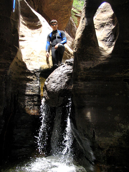
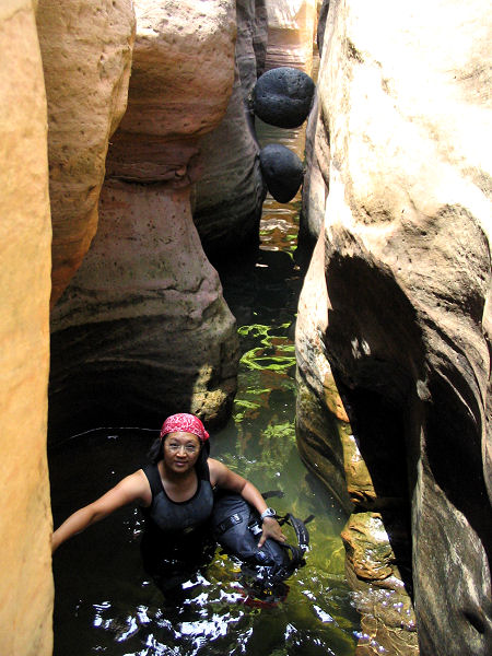
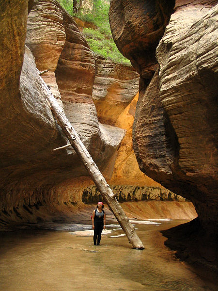
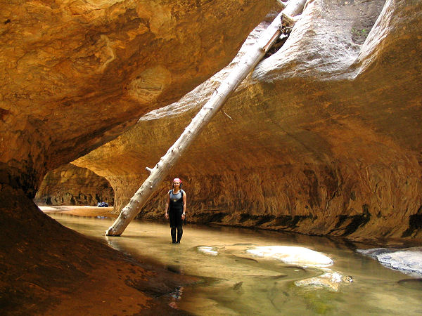
Upper Route: From the Wildcat Trailhead begin walking on the wide, flat, well established trail as it winds it's way through a Ponderosa Pine forest. After about 15 minutes (0.9 miles) you reach a signed junction for West Rim Trail (straight), Hop Valley (4 miles, right), stay straight. Shortly beyond, you'll reach another signed junction: Northgate Peaks (right), Wildcat Canyon (straight), turn right towards Northgate Peaks. The trail splits immediately afterwards: Northgate Peaks (right), Subway Route (left), turn left towards the Subway. The path heads towards the prominent canyon on your left (Russel Gulch). There are a few cairns and metal signs marked with a boot print as you begin your descent into the gulch along the slick rock slope. The trail is not well defined on the rock, but becomes distinct in sections as you pass through forested areas along the slope. Just below the confluence of two upper drainages in the gulch the trail bends left, drops down steeply, then crosses over the drainage bottom and begins climbing the slick rock on the left towards a prominent stone dome shaped mound. After passing the mound, you'll descend an interesting slope of cross bedded sandstone. The path then passes back into the forest, and begins a steep descent into the main drainage of the left fork of North Creek, reaching the bottom just below a dryfall and pool. In the canyon bottom turn right and head down canyon (left also looks interesting if you have time to explore). A short distance down canyon you'll reach a large boulder blocking your path, climb down the 12' drop on the right (a hand line may be helpful). Continuing on, the canyon becomes more narrow and you will have to complete two short pothole swims in icy cold water. There are a few down climbs as you enter a stretch of narrows then another climb into a narrow water filled corridor which has two beachball sized choke stones wedged 1/2 way through. Shortly afterwards you will reach a 15' waterfall. There are two bolts and hangers on the right (one good hanger, the other looks like a cheesy metal shop project). There is a carabineer on the good hanger that you can put your rope through for use as a hand line or rappel down the falls. The Subway lies just below the falls. Take your photos (a tripod may prove useful) and move on so others can enjoy the area. The next obstacle is a water fall and drop off. If you only brought a short rope you can work your way down on the left to a place where a 6' jump is required to get back down into the canyon bottom, or with a 75' rope use the two bolts with hangers and chains on the left to hand line (or rappel) down the slope. The area below is also quite photogenic with some nice potholes and cascades. Below The Subway, the canyon widens though is still nice at first as it travels over some red rock cascades and water falls. Lower down the hike is just a boulder hop with sections of use trail on one side of the stream or the other (usually on the right). It is a long rather dull slog down canyon for the next 1 1/2 hours or so. You'll know your getting close to your exit point when you pass a stream which enters the canyon from the right. About 15 minutes past this stream look for a sign on the right for The Left Fork Trailhead. Turn right and follow the trail as it climbs steeply up and out of the canyon. Finally the trail reaches the plateau and levels out as it winds its way through the junipers to the Left Fork Trailhead. From here; walk, jog, bicycle, hitchhike or drive back to the Wildcat Trailhead and your car.
Lower Route: From the Left Fork Trailhead, follow the path through the junipers then steeply down into the drainage of the Left Fork of North Creek. Turn left and hike & boulder hop your way up canyon to the Subway. You will be able to view the lower section of the Subway up to the falls, but climbing the falls may prove to be difficult unless there are people coming down from above that can let you use their rope (but remember you have to get down again as well). If you can't get up the falls you'll miss the best part of the hike, but at least you won't have to go for an icy swim. |
| Rating (1-5 stars): |
   
While the Subway itself is spectacular, the slog through the lower canyon is rather mediocre. The author and his wife have completed this hike from the Upper Route on two occasions. We only had one car, so after completing the hike the author stashed his pack and jogged & walked the steep road back to the car (not really recommended). Total hike time between the two trailheads was 6 hours. |
| Maps: |
Trails Illustrated - Zion National Park, Zion N.P. Park Map |
| Books: |
Canyon
Hiking Guide to the Colorado Plateau -
Michael Kelsey |
| Photos: |
Click picture for larger view, click your browser's 'Back' button to return to this page. |
 |
 |
|
Down climb or rappel. |
A
cold swim. |
 |
 |
|
The Subway. |
Another view
in the Subway. |
|
|

